![](/images/other/stat-length.png)
![Excursión Paseo ecuestre Montrésor - montrésor-orbigny_20 - Photo](https://media.geolcdn.com/t/1900/400/e7cb1079-74e3-44e9-a416-3eaebd4c2012.jpg&format=pjpeg&maxdim=2)
montrésor-orbigny_20
COMITE EQUESTRE TOURISME 37
Usuario
![Longitud](/images/other/stat-length.png)
Longitud
19,3 km
![Altitud máxima](https://static1.geolcdn.com/siteimages/upload/files/1508320355ic_sort_altitude_max_24dp.png)
Altitud máxima
143 m
![Desnivel positivo](https://static1.geolcdn.com/siteimages/upload/files/1508320355ic_sort_den_pos_24dp.png)
Desnivel positivo
219 m
![Km-Effort](/images/other/stat-length.png)
Km-Effort
22 km
![Altitud mínima](https://static1.geolcdn.com/siteimages/upload/files/1508320355ic_sort_altitude_min_24dp.png)
Altitud mínima
91 m
![Desnivel negativo](https://static1.geolcdn.com/siteimages/upload/files/1508320355ic_sort_den_neg_24dp.png)
Desnivel negativo
219 m
![Boucle](https://static1.geolcdn.com/siteimages/upload/files/16400158638029165_repeat_loop_refresh_sync_direction_icon.png)
Boucle
Sí
Fecha de creación :
2022-04-09 15:43:04.589
Última modificación :
2022-04-09 15:45:12.132
![Paseo ecuestre](https://static1.geolcdn.com/sitytour/trail-icons/301.png)
2h55
Dificultad : Medio
![Enganche](https://static1.geolcdn.com/sitytour/trail-icons/302.png)
0m
Dificultad : Muy fácil
![Escanee este código QR para abrir la excursión en la aplicación SityTrail](https://capi.geolives.com/qq0zvz2zws4bq2lad0pu/sitytour/trails/3198049/qr.png?size=200)
Aplicación GPS de excursión GRATIS
A propósito
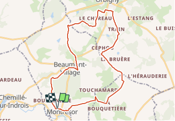
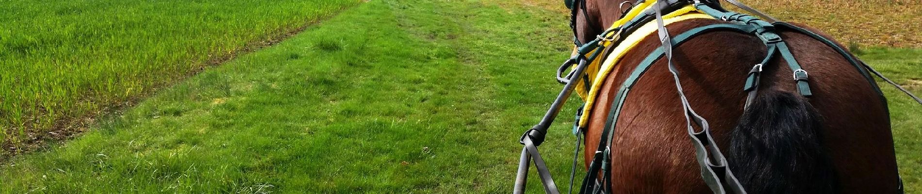
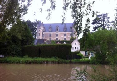
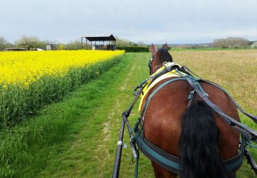
Ruta Paseo ecuestre de 19,3 km a descubrir en Centro, Indre y Loira, Montrésor. Esta ruta ha sido propuesta por COMITE EQUESTRE TOURISME 37.
Descripción
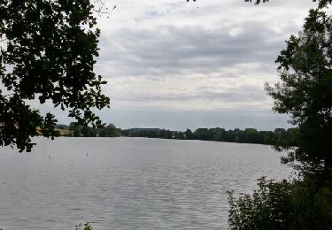
avec un petit gué et un beau chateau, le paysage de cette campagne est magnifique au printemps mais aussi en toutes saisons
Puntos de interés
Localización
País:
France
Región :
Centro
Departamento/provincia :
Indre y Loira
Municipio :
Montrésor
Localidad:
Unknown
Salida:(Dec)
Salida:(UTM)
363444 ; 5224313 (31T) N.
Comentarios
Excursiones cerca
![Senderismo Senderismo](https://static1.geolcdn.com/sitytour/trail-icons/101.png)
Chemillé sur Indrois Montresor
Senderismo
Medio
Chemillé-sur-Indrois,
Centro,
Indre y Loira,
France
![](/images/other/stat-length.png)
22 km | 26 km-effort
5h 19min
![](https://static1.geolcdn.com/siteimages/upload/files/16400158638029165_repeat_loop_refresh_sync_direction_icon.png)
No
![Excursión Senderismo Montrésor - Montrésor : chemin des Légendes - Photo](https://media.geolcdn.com/t/375/260/ext.jpg?maxdim=2&url=https%3A%2F%2Fservices.sitytrail.com%2FGeolivesWS%2FDownloadMedia.ashx%3FTrailID%3D413013%26Media%3D20150427100435.jpg)
![Senderismo Senderismo](https://static1.geolcdn.com/sitytour/trail-icons/101.png)
Montrésor : chemin des Légendes
Senderismo
Muy fácil
Montrésor,
Centro,
Indre y Loira,
France
![](/images/other/stat-length.png)
10,5 km | 12,1 km-effort
3h 39min
![](https://static1.geolcdn.com/siteimages/upload/files/16400158638029165_repeat_loop_refresh_sync_direction_icon.png)
Sí
![Excursión Paseo ecuestre Beaumont-Village - beaumontvillage_15 - Photo](https://media.geolcdn.com/t/375/260/2463fe9e-1897-4c16-9584-e7524d968a7d.jpg&format=jpg&maxdim=2)
![Paseo ecuestre Paseo ecuestre](https://static1.geolcdn.com/sitytour/trail-icons/301.png)
beaumontvillage_15
Paseo ecuestre
Fácil
Beaumont-Village,
Centro,
Indre y Loira,
France
![](/images/other/stat-length.png)
12,3 km | 14,3 km-effort
1h 52min
![](https://static1.geolcdn.com/siteimages/upload/files/16400158638029165_repeat_loop_refresh_sync_direction_icon.png)
Sí
![Excursión Senderismo Chemillé-sur-Indrois - Petit circuit du Moulin des Roches - Photo](https://media.geolcdn.com/t/375/260/ext.jpg?maxdim=2&url=https%3A%2F%2Fservices.sitytrail.com%2FGeolivesWS%2FDownloadMedia.ashx%3FTrailID%3D786504%26Media%3Dfix__20170709113151.jpg)
![Senderismo Senderismo](https://static1.geolcdn.com/sitytour/trail-icons/101.png)
Petit circuit du Moulin des Roches
Senderismo
Muy fácil
Chemillé-sur-Indrois,
Centro,
Indre y Loira,
France
![](/images/other/stat-length.png)
3,3 km | 4 km-effort
49min
![](https://static1.geolcdn.com/siteimages/upload/files/16400158638029165_repeat_loop_refresh_sync_direction_icon.png)
Sí
![Excursión Senderismo Montrésor - Montrésor 2 - Photo](https://media.geolcdn.com/t/375/260/9949515c-769d-44e6-ba21-526b9af069fc.jpg&format=jpg&maxdim=2)
![Senderismo Senderismo](https://static1.geolcdn.com/sitytour/trail-icons/101.png)
Montrésor 2
Senderismo
Muy fácil
Montrésor,
Centro,
Indre y Loira,
France
![](/images/other/stat-length.png)
10 km | 11,6 km-effort
3h 32min
![](https://static1.geolcdn.com/siteimages/upload/files/16400158638029165_repeat_loop_refresh_sync_direction_icon.png)
Sí
![Excursión Senderismo Chemillé-sur-Indrois - 1-01-2025 - Photo](https://media.geolcdn.com/t/375/260/ext.jpg?maxdim=2&url=https%3A%2F%2Fstatic1.geolcdn.com%2Fsiteimages%2Fupload%2Ffiles%2F1553511878bg_sport_marche.png)
![Senderismo Senderismo](https://static1.geolcdn.com/sitytour/trail-icons/101.png)
1-01-2025
Senderismo
Medio
Chemillé-sur-Indrois,
Centro,
Indre y Loira,
France
![](/images/other/stat-length.png)
10 km | 11,6 km-effort
4h 10min
![](https://static1.geolcdn.com/siteimages/upload/files/16400158638029165_repeat_loop_refresh_sync_direction_icon.png)
Sí
![Excursión Senderismo Chemillé-sur-Indrois - Montrésor, le chemin des Légendes-15491655 - Photo](https://media.geolcdn.com/t/375/260/ext.jpg?maxdim=2&url=https%3A%2F%2Fstatic1.geolcdn.com%2Fsiteimages%2Fupload%2Ffiles%2F1553511878bg_sport_marche.png)
![Senderismo Senderismo](https://static1.geolcdn.com/sitytour/trail-icons/101.png)
Montrésor, le chemin des Légendes-15491655
Senderismo
Medio
Chemillé-sur-Indrois,
Centro,
Indre y Loira,
France
![](/images/other/stat-length.png)
8,6 km | 10,1 km-effort
2h 18min
![](https://static1.geolcdn.com/siteimages/upload/files/16400158638029165_repeat_loop_refresh_sync_direction_icon.png)
Sí
![Excursión Marcha nórdica Montrésor - Mon trésor - Photo](https://media.geolcdn.com/t/375/260/ext.jpg?maxdim=2&url=https%3A%2F%2Fstatic1.geolcdn.com%2Fsiteimages%2Fupload%2Ffiles%2F1545311037marcheuse_200dpi.jpg)
![Marcha nórdica Marcha nórdica](https://static1.geolcdn.com/sitytour/trail-icons/102.png)
Mon trésor
Marcha nórdica
Montrésor,
Centro,
Indre y Loira,
France
![](/images/other/stat-length.png)
8,1 km | 9,3 km-effort
3h 1min
![](https://static1.geolcdn.com/siteimages/upload/files/16400158638029165_repeat_loop_refresh_sync_direction_icon.png)
No
![Excursión Senderismo Villeloin-Coulangé - villeloin coulangé - Photo](https://media.geolcdn.com/t/375/260/ext.jpg?maxdim=2&url=https%3A%2F%2Fstatic1.geolcdn.com%2Fsiteimages%2Fupload%2Ffiles%2F1553511878bg_sport_marche.png)
![Senderismo Senderismo](https://static1.geolcdn.com/sitytour/trail-icons/101.png)
villeloin coulangé
Senderismo
Difícil
Villeloin-Coulangé,
Centro,
Indre y Loira,
France
![](/images/other/stat-length.png)
11,5 km | 13,3 km-effort
2h 17min
![](https://static1.geolcdn.com/siteimages/upload/files/16400158638029165_repeat_loop_refresh_sync_direction_icon.png)
Sí