![](/images/other/stat-length.png)
![Excursión Senderismo Saint-Martin-la-Plaine - rando autour de St Martin la plaine, - Photo](https://media.geolcdn.com/t/1900/400/edbc12e4-5772-4b73-9ba2-a3d81bfb5c32.jpg&format=pjpeg&maxdim=2)
rando autour de St Martin la plaine,
mimi69670
Usuario
![Longitud](/images/other/stat-length.png)
Longitud
10,4 km
![Altitud máxima](https://static1.geolcdn.com/siteimages/upload/files/1508320355ic_sort_altitude_max_24dp.png)
Altitud máxima
606 m
![Desnivel positivo](https://static1.geolcdn.com/siteimages/upload/files/1508320355ic_sort_den_pos_24dp.png)
Desnivel positivo
237 m
![Km-Effort](/images/other/stat-length.png)
Km-Effort
13,6 km
![Altitud mínima](https://static1.geolcdn.com/siteimages/upload/files/1508320355ic_sort_altitude_min_24dp.png)
Altitud mínima
424 m
![Desnivel negativo](https://static1.geolcdn.com/siteimages/upload/files/1508320355ic_sort_den_neg_24dp.png)
Desnivel negativo
236 m
![Boucle](https://static1.geolcdn.com/siteimages/upload/files/16400158638029165_repeat_loop_refresh_sync_direction_icon.png)
Boucle
Sí
Fecha de creación :
2022-04-09 07:33:35.188
Última modificación :
2022-04-09 11:02:18.427
![Senderismo](https://static1.geolcdn.com/sitytour/trail-icons/101.png)
3h06
Dificultad : Fácil
![Escanee este código QR para abrir la excursión en la aplicación SityTrail](https://capi.geolives.com/qq0zvz2zws4bq2lad0pu/sitytour/trails/3197532/qr.png?size=200)
Aplicación GPS de excursión GRATIS
A propósito
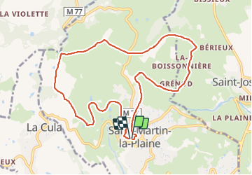
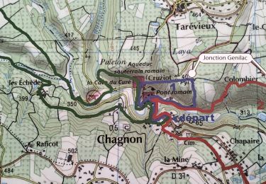
Ruta Senderismo de 10,4 km a descubrir en Auvergne-Rhône-Alpes, Loira, Saint-Martin-la-Plaine. Esta ruta ha sido propuesta por mimi69670.
Descripción
Départ de St Martin la Plaine, grimpez sur les crets et points de vue sur le Pilât et par temps clair, la chaîne des Alpes
Localización
País:
France
Región :
Auvergne-Rhône-Alpes
Departamento/provincia :
Loira
Municipio :
Saint-Martin-la-Plaine
Localidad:
Unknown
Salida:(Dec)
Salida:(UTM)
624175 ; 5044856 (31T) N.
Comentarios
Excursiones cerca
![Excursión Senderismo La Grand-Croix - MOYENNE MARCHE - Photo](https://media.geolcdn.com/t/375/260/ext.jpg?maxdim=2&url=https%3A%2F%2Fstatic1.geolcdn.com%2Fsiteimages%2Fupload%2Ffiles%2F1553511878bg_sport_marche.png)
![Senderismo Senderismo](https://static1.geolcdn.com/sitytour/trail-icons/101.png)
MOYENNE MARCHE
Senderismo
Muy fácil
(1)
La Grand-Croix,
Auvergne-Rhône-Alpes,
Loira,
France
![](/images/other/stat-length.png)
3,8 km | 5 km-effort
1h 1min
![](https://static1.geolcdn.com/siteimages/upload/files/16400158638029165_repeat_loop_refresh_sync_direction_icon.png)
Sí
![Excursión Senderismo Chagnon - 42_Chagnon_13km470m - Photo](https://media.geolcdn.com/t/375/260/7ea874cc-cd00-4c8f-a5f4-5d79cdc17a88.jpg&format=jpg&maxdim=2)
![Senderismo Senderismo](https://static1.geolcdn.com/sitytour/trail-icons/101.png)
42_Chagnon_13km470m
Senderismo
Medio
Chagnon,
Auvergne-Rhône-Alpes,
Loira,
France
![](/images/other/stat-length.png)
13,1 km | 19,3 km-effort
2h 58min
![](https://static1.geolcdn.com/siteimages/upload/files/16400158638029165_repeat_loop_refresh_sync_direction_icon.png)
Sí
![Excursión Senderismo Saint-Joseph - 42-st-joseph-10km-320m - Photo](https://media.geolcdn.com/t/375/260/d6018596-5a38-4194-9525-041abab6ce05.jpg&format=jpg&maxdim=2)
![Senderismo Senderismo](https://static1.geolcdn.com/sitytour/trail-icons/101.png)
42-st-joseph-10km-320m
Senderismo
Fácil
Saint-Joseph,
Auvergne-Rhône-Alpes,
Loira,
France
![](/images/other/stat-length.png)
10,5 km | 14,8 km-effort
2h 50min
![](https://static1.geolcdn.com/siteimages/upload/files/16400158638029165_repeat_loop_refresh_sync_direction_icon.png)
Sí
![Excursión Senderismo Chabanière - 69-st-maurice-dargoire2-19km-580m - Photo](https://media.geolcdn.com/t/375/260/c4b20fd4-ad58-4836-9971-2020b70efe6f.jpg&format=jpg&maxdim=2)
![Senderismo Senderismo](https://static1.geolcdn.com/sitytour/trail-icons/101.png)
69-st-maurice-dargoire2-19km-580m
Senderismo
Difícil
Chabanière,
Auvergne-Rhône-Alpes,
Ródano,
France
![](/images/other/stat-length.png)
19,2 km | 27 km-effort
5h 47min
![](https://static1.geolcdn.com/siteimages/upload/files/16400158638029165_repeat_loop_refresh_sync_direction_icon.png)
Sí
![Excursión Senderismo Chabanière - 69_st_maurice_dargeoire_12km_300m - Photo](https://media.geolcdn.com/t/375/260/83f5b7e0-e7a1-44e9-9c6c-d04e1b215358.jpg&format=jpg&maxdim=2)
![Senderismo Senderismo](https://static1.geolcdn.com/sitytour/trail-icons/101.png)
69_st_maurice_dargeoire_12km_300m
Senderismo
Medio
Chabanière,
Auvergne-Rhône-Alpes,
Ródano,
France
![](/images/other/stat-length.png)
11,6 km | 15,5 km-effort
3h 31min
![](https://static1.geolcdn.com/siteimages/upload/files/16400158638029165_repeat_loop_refresh_sync_direction_icon.png)
Sí
![Excursión Senderismo Saint-Martin-la-Plaine - 42-martinlaplaine-12km450m - Photo](https://media.geolcdn.com/t/375/260/0bbcbe3d-ff1f-4c48-95ef-874625509cfa.jpg&format=jpg&maxdim=2)
![Senderismo Senderismo](https://static1.geolcdn.com/sitytour/trail-icons/101.png)
42-martinlaplaine-12km450m
Senderismo
Difícil
Saint-Martin-la-Plaine,
Auvergne-Rhône-Alpes,
Loira,
France
![](/images/other/stat-length.png)
12,9 km | 18,9 km-effort
4h 17min
![](https://static1.geolcdn.com/siteimages/upload/files/16400158638029165_repeat_loop_refresh_sync_direction_icon.png)
Sí
![Excursión Senderismo Cellieu - Cellier Valfleurie - Photo](https://media.geolcdn.com/t/375/260/ddbd041f-9f5b-41f8-ae6c-ee02ff5e9afa.jpg&format=jpg&maxdim=2)
![Senderismo Senderismo](https://static1.geolcdn.com/sitytour/trail-icons/101.png)
Cellier Valfleurie
Senderismo
Medio
Cellieu,
Auvergne-Rhône-Alpes,
Loira,
France
![](/images/other/stat-length.png)
19,3 km | 29 km-effort
4h 37min
![](https://static1.geolcdn.com/siteimages/upload/files/16400158638029165_repeat_loop_refresh_sync_direction_icon.png)
No
![Excursión Senderismo Cellieu - cellieu partiel pournphotos - Photo](https://media.geolcdn.com/t/375/260/fee08f5c-9bca-4082-bdf2-49f590ea9fc1.jpg&format=jpg&maxdim=2)
![Senderismo Senderismo](https://static1.geolcdn.com/sitytour/trail-icons/101.png)
cellieu partiel pournphotos
Senderismo
Medio
Cellieu,
Auvergne-Rhône-Alpes,
Loira,
France
![](/images/other/stat-length.png)
11 km | 17,9 km-effort
2h 37min
![](https://static1.geolcdn.com/siteimages/upload/files/16400158638029165_repeat_loop_refresh_sync_direction_icon.png)
No
![Excursión Senderismo Cellieu - Cellieu - Photo](https://media.geolcdn.com/t/375/260/ext.jpg?maxdim=2&url=https%3A%2F%2Fstatic1.geolcdn.com%2Fsiteimages%2Fupload%2Ffiles%2F1553511878bg_sport_marche.png)
![Senderismo Senderismo](https://static1.geolcdn.com/sitytour/trail-icons/101.png)
Cellieu
Senderismo
Medio
(1)
Cellieu,
Auvergne-Rhône-Alpes,
Loira,
France
![](/images/other/stat-length.png)
19,2 km | 28 km-effort
6h 29min
![](https://static1.geolcdn.com/siteimages/upload/files/16400158638029165_repeat_loop_refresh_sync_direction_icon.png)
Sí