![](/images/other/stat-length.png)
![Excursión Ruta Digne-les-Bains - t13907 Trail du Cousson 18 km-R-MNT - Photo](https://media.geolcdn.com/t/1900/400/ext.pjpeg?maxdim=2&url=https%3A%2F%2Fstatic1.geolcdn.com%2Fsiteimages%2Fupload%2Ffiles%2F1524743154running.jpg)
t13907 Trail du Cousson 18 km-R-MNT
phd04
Usuario
![Longitud](/images/other/stat-length.png)
![Altitud máxima](https://static1.geolcdn.com/siteimages/upload/files/1508320355ic_sort_altitude_max_24dp.png)
![Desnivel positivo](https://static1.geolcdn.com/siteimages/upload/files/1508320355ic_sort_den_pos_24dp.png)
![Km-Effort](/images/other/stat-length.png)
![Altitud mínima](https://static1.geolcdn.com/siteimages/upload/files/1508320355ic_sort_altitude_min_24dp.png)
![Desnivel negativo](https://static1.geolcdn.com/siteimages/upload/files/1508320355ic_sort_den_neg_24dp.png)
![Boucle](https://static1.geolcdn.com/siteimages/upload/files/16400158638029165_repeat_loop_refresh_sync_direction_icon.png)
![Ruta](https://static1.geolcdn.com/sitytour/trail-icons/104.png)
0m
Dificultad : Difícil
![Escanee este código QR para abrir la excursión en la aplicación SityTrail](https://capi.geolives.com/qq0zvz2zws4bq2lad0pu/sitytour/trails/3196947/qr.png?size=200)
Aplicación GPS de excursión GRATIS
A propósito
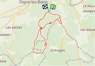
Ruta Ruta de 17,4 km a descubrir en Provenza-Alpes-Costa Azul, Alpes de Alta Provenza, Digne-les-Bains. Esta ruta ha sido propuesta por phd04.
Descripción
Ce parcours est le 18 km du Trail du Cousson. Le départ s'effectue du Pré Fiaschi situé à 1 km environ du centre de ville sur la route des Thermes. Par des sentiers et des pistes forestières ont accède au sommet du Cousson (1516 m) par le Pas d'Entrages. Avant le sommet vous pourrez voir la Chapelle St Michel du Cousson en équilibre sur un éperon rocheux. Encore quelques mètres à gravir et vous arrivez à un petit cairn qui symbolise le sommet. Et là, une vue époustouflante à 360° avec au nord Les Ecrins, à l'ouest la montagne de Lure et le mont Ventoux et à l'Est la Barre des Dourbes. La descente se fait par le Vallon des Sources
Localización
Comentarios
Excursiones cerca
![Excursión Senderismo Digne-les-Bains - Le Cousson - Photo](https://media.geolcdn.com/t/375/260/5cf44ebe-1058-41b6-9fbf-2454217c16da.jpg&format=jpg&maxdim=2)
![Senderismo Senderismo](https://static1.geolcdn.com/sitytour/trail-icons/101.png)
Senderismo
![](/images/other/stat-length.png)
![](https://static1.geolcdn.com/siteimages/upload/files/16400158638029165_repeat_loop_refresh_sync_direction_icon.png)
![Excursión Senderismo Digne-les-Bains - Autour de Courbons - Digne les Bains - Photo](https://media.geolcdn.com/t/375/260/ext.jpg?maxdim=2&url=https%3A%2F%2Fservices.sitytrail.com%2FGeolivesWS%2FDownloadMedia.ashx%3FTrailID%3D173256%26Media%3D14871_6.jpg)
![Senderismo Senderismo](https://static1.geolcdn.com/sitytour/trail-icons/101.png)
Senderismo
![](/images/other/stat-length.png)
![](https://static1.geolcdn.com/siteimages/upload/files/16400158638029165_repeat_loop_refresh_sync_direction_icon.png)
![Excursión Senderismo Digne-les-Bains - courbon la bigue 15kms 900m - Photo](https://media.geolcdn.com/t/375/260/eeca4995-0c3e-4d59-97a2-ea69c1d4e6a1.jpg&format=jpg&maxdim=2)
![Senderismo Senderismo](https://static1.geolcdn.com/sitytour/trail-icons/101.png)
Senderismo
![](/images/other/stat-length.png)
![](https://static1.geolcdn.com/siteimages/upload/files/16400158638029165_repeat_loop_refresh_sync_direction_icon.png)
![Excursión Senderismo Digne-les-Bains - DIGNE. LA PLATRIERE. RUINES DE GIVAUDAN. CHAPELLE MADELEINE. O L S - Photo](https://media.geolcdn.com/t/375/260/80b6f901-b276-4568-b80a-9babbef2a5d9.jpg&format=jpg&maxdim=2)
![Senderismo Senderismo](https://static1.geolcdn.com/sitytour/trail-icons/101.png)
Senderismo
![](/images/other/stat-length.png)
![](https://static1.geolcdn.com/siteimages/upload/files/16400158638029165_repeat_loop_refresh_sync_direction_icon.png)
![Excursión Senderismo Digne-les-Bains - Chapelle St Pancrace 18.11.23 - Photo](https://media.geolcdn.com/t/375/260/583976d8-25d3-4c43-8a1a-417f5de6b4ec.jpg&format=jpg&maxdim=2)
![Senderismo Senderismo](https://static1.geolcdn.com/sitytour/trail-icons/101.png)
Senderismo
![](/images/other/stat-length.png)
![](https://static1.geolcdn.com/siteimages/upload/files/16400158638029165_repeat_loop_refresh_sync_direction_icon.png)
![Excursión Senderismo Marcoux - DIGNE . LES ROBINES DU BANASTRE n ol - Photo](https://media.geolcdn.com/t/375/260/dcce991a-de45-4ec5-a0f2-a1115a3d83c1.jpg&format=jpg&maxdim=2)
![Senderismo Senderismo](https://static1.geolcdn.com/sitytour/trail-icons/101.png)
Senderismo
![](/images/other/stat-length.png)
![](https://static1.geolcdn.com/siteimages/upload/files/16400158638029165_repeat_loop_refresh_sync_direction_icon.png)
![Excursión Senderismo Digne-les-Bains - ENTRAGES Tour et crête du Feston o s l - Photo](https://media.geolcdn.com/t/375/260/446f1e20-ab99-4ceb-a654-6accbeab3d1a.jpg&format=jpg&maxdim=2)
![Senderismo Senderismo](https://static1.geolcdn.com/sitytour/trail-icons/101.png)
Senderismo
![](/images/other/stat-length.png)
![](https://static1.geolcdn.com/siteimages/upload/files/16400158638029165_repeat_loop_refresh_sync_direction_icon.png)
![Excursión Senderismo Digne-les-Bains - 65bis-Digne- Cousson N et S- Caramantran- Digne - Photo](https://media.geolcdn.com/t/375/260/ext.jpg?maxdim=2&url=https%3A%2F%2Fstatic1.geolcdn.com%2Fsiteimages%2Fupload%2Ffiles%2F1553511878bg_sport_marche.png)
![Senderismo Senderismo](https://static1.geolcdn.com/sitytour/trail-icons/101.png)
Senderismo
![](/images/other/stat-length.png)
![](https://static1.geolcdn.com/siteimages/upload/files/16400158638029165_repeat_loop_refresh_sync_direction_icon.png)
![Excursión Bici de montaña Digne-les-Bains - Terres Noires 2011 (50km) - Photo](https://media.geolcdn.com/t/375/260/ext.jpg?maxdim=2&url=https%3A%2F%2Fstatic1.geolcdn.com%2Fsiteimages%2Fupload%2Ffiles%2F1524743154velo.jpg)
![Bici de montaña Bici de montaña](https://static1.geolcdn.com/sitytour/trail-icons/202.png)
Bici de montaña
![](/images/other/stat-length.png)
![](https://static1.geolcdn.com/siteimages/upload/files/16400158638029165_repeat_loop_refresh_sync_direction_icon.png)