![](/images/other/stat-length.png)
![Excursión Senderismo Aspères - Asperes-Clement-Gailhan-Lecques - Photo](https://media.geolcdn.com/t/1900/400/9a1bc5a1-f360-49eb-98f9-c8295228c694.jpg&format=pjpeg&maxdim=2)
Asperes-Clement-Gailhan-Lecques
v.rabot
Usuario
![Longitud](/images/other/stat-length.png)
![Altitud máxima](https://static1.geolcdn.com/siteimages/upload/files/1508320355ic_sort_altitude_max_24dp.png)
![Desnivel positivo](https://static1.geolcdn.com/siteimages/upload/files/1508320355ic_sort_den_pos_24dp.png)
![Km-Effort](/images/other/stat-length.png)
![Altitud mínima](https://static1.geolcdn.com/siteimages/upload/files/1508320355ic_sort_altitude_min_24dp.png)
![Desnivel negativo](https://static1.geolcdn.com/siteimages/upload/files/1508320355ic_sort_den_neg_24dp.png)
![Boucle](https://static1.geolcdn.com/siteimages/upload/files/16400158638029165_repeat_loop_refresh_sync_direction_icon.png)
![Senderismo](https://static1.geolcdn.com/sitytour/trail-icons/101.png)
5h00
Dificultad : Medio
![Escanee este código QR para abrir la excursión en la aplicación SityTrail](https://capi.geolives.com/qq0zvz2zws4bq2lad0pu/sitytour/trails/3190414/qr.png?size=200)
Aplicación GPS de excursión GRATIS
A propósito
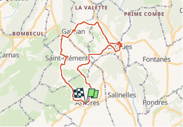
Ruta Senderismo de 18,1 km a descubrir en Occitania, Gard, Aspères. Esta ruta ha sido propuesta por v.rabot.
Descripción
Partant du parking d'Aspères, on passe sur le vieux cimetière d'Aspères complétement abandonné et on se dirige vers Saint Clément où on peut admirer un beau petit pont avec une table de pique-nique propice à la pause café, on admire au passage, la croix datant de 1765 avant de passer devant la mairie pour rejoindre Gailhan, où il y a aussi un petit parc ombragé, passage devant l'église du 11e siècle pour se diriger vers Lecques ou on trouvera aussi un parc ombragé avec deux tables de pique-niques pour la pause déjeuner, on pourra admirer la rénovation de l'ancienne cave coopérative, l'ancienne chapelle près de la mairie, on redescendra sur le vidourle pour remonter sur l'église et passer dans quelques petites ruelles du village, pour reprendre la direction d'Aspères en passant près d'une source et en traversant un joli ruisseau (suivant la saison) pour faire la dernière montée du bois de Boulou, retour sur Aspères, passage devant l'église et la magnanerie, puis retour au parking. Les chemins sont généralement bons, les routes goudronnées n'avaient pas de circulation de véhicules. Aucune difficulté sur ce parcours
Localización
Comentarios
Excursiones cerca
![Excursión Senderismo Fontanès - FONTANÉS 30 - SALINELLES - PONDRES - ballade autour du Vidourle - Photo](https://media.geolcdn.com/t/375/260/ext.jpg?maxdim=2&url=https%3A%2F%2Fservices.sitytrail.com%2FGeolivesWS%2FDownloadMedia.ashx%3FTrailID%3D446731%26Media%3D20150718095958.jpg)
![Senderismo Senderismo](https://static1.geolcdn.com/sitytour/trail-icons/101.png)
Senderismo
![](/images/other/stat-length.png)
![](https://static1.geolcdn.com/siteimages/upload/files/16400158638029165_repeat_loop_refresh_sync_direction_icon.png)
![Excursión Senderismo Sommières - SOMMIERES 30 - VILLEVIEILLE châteaux- JUNAS les carrières - Photo](https://media.geolcdn.com/t/375/260/ext.jpg?maxdim=2&url=https%3A%2F%2Fservices.sitytrail.com%2FGeolivesWS%2FDownloadMedia.ashx%3FTrailID%3D421587%26Media%3D20150516132041.jpg)
![Senderismo Senderismo](https://static1.geolcdn.com/sitytour/trail-icons/101.png)
Senderismo
![](/images/other/stat-length.png)
![](https://static1.geolcdn.com/siteimages/upload/files/16400158638029165_repeat_loop_refresh_sync_direction_icon.png)
![Excursión Senderismo Carnas - Carnas bois de Paris - Photo](https://media.geolcdn.com/t/375/260/ext.jpg?maxdim=2&url=https%3A%2F%2Fservices.sitytrail.com%2FGeolivesWS%2FDownloadMedia.ashx%3FTrailID%3D178653%26Media%3D20130304133341.jpeg)
![Senderismo Senderismo](https://static1.geolcdn.com/sitytour/trail-icons/101.png)
Senderismo
![](/images/other/stat-length.png)
![](https://static1.geolcdn.com/siteimages/upload/files/16400158638029165_repeat_loop_refresh_sync_direction_icon.png)
![Excursión Senderismo Saint-Clément - Le bois de Paris - Grotte, Table d'orientation, Oppidum - Photo](https://media.geolcdn.com/t/375/260/ext.jpg?maxdim=2&url=https%3A%2F%2Fstatic1.geolcdn.com%2Fsiteimages%2Fupload%2Ffiles%2F1553511878bg_sport_marche.png)
![Senderismo Senderismo](https://static1.geolcdn.com/sitytour/trail-icons/101.png)
Senderismo
![](/images/other/stat-length.png)
![](https://static1.geolcdn.com/siteimages/upload/files/16400158638029165_repeat_loop_refresh_sync_direction_icon.png)
![Excursión Senderismo Sommières - Autour de Villevielle 30 - Photo](https://media.geolcdn.com/t/375/260/ext.jpg?maxdim=2&url=https%3A%2F%2Fstatic1.geolcdn.com%2Fsiteimages%2Fupload%2Ffiles%2F1553511878bg_sport_marche.png)
![Senderismo Senderismo](https://static1.geolcdn.com/sitytour/trail-icons/101.png)
Senderismo
![](/images/other/stat-length.png)
![](https://static1.geolcdn.com/siteimages/upload/files/16400158638029165_repeat_loop_refresh_sync_direction_icon.png)
![Excursión Senderismo Sommières - Les boucles du Vidourle - Photo](https://media.geolcdn.com/t/375/260/60623f25-e960-4316-892a-026a76081c35.jpg&format=jpg&maxdim=2)
![Senderismo Senderismo](https://static1.geolcdn.com/sitytour/trail-icons/101.png)
Senderismo
![](/images/other/stat-length.png)
![](https://static1.geolcdn.com/siteimages/upload/files/16400158638029165_repeat_loop_refresh_sync_direction_icon.png)
![Excursión Senderismo Aspères - Aspères - Photo](https://media.geolcdn.com/t/375/260/3aa1cad7-a037-4103-94ea-4f508e99c3ef.jpg&format=jpg&maxdim=2)
![Senderismo Senderismo](https://static1.geolcdn.com/sitytour/trail-icons/101.png)
![Excursión Senderismo Salinelles - salinelles-pondres-souvignargues-fontanes - Photo](https://media.geolcdn.com/t/375/260/1607f42f-3da2-4ff5-8f21-3a0fa46d978d.jpg&format=jpg&maxdim=2)
![Senderismo Senderismo](https://static1.geolcdn.com/sitytour/trail-icons/101.png)
Senderismo
![](/images/other/stat-length.png)
![](https://static1.geolcdn.com/siteimages/upload/files/16400158638029165_repeat_loop_refresh_sync_direction_icon.png)
![Excursión Senderismo Sommières - Les matches de géants - Photo](https://media.geolcdn.com/t/375/260/bdfb56a8-bc1e-4310-8247-963986d83761.jpg&format=jpg&maxdim=2)
![Senderismo Senderismo](https://static1.geolcdn.com/sitytour/trail-icons/101.png)
Senderismo
![](/images/other/stat-length.png)
![](https://static1.geolcdn.com/siteimages/upload/files/16400158638029165_repeat_loop_refresh_sync_direction_icon.png)