![](/images/other/stat-length.png)
![Excursión Senderismo Lannes - La balade de Gachot - Lannes - Photo](https://media.geolcdn.com/t/1900/400/ext.pjpeg?maxdim=2&url=https%3A%2F%2Fservices.sitytrail.com%2FGeolivesWS%2FDownloadMedia.ashx%3FTrailID%3D317748%26Media%3D17062_2.jpg)
La balade de Gachot - Lannes
tracegps
Usuario
![Longitud](/images/other/stat-length.png)
![Altitud máxima](https://static1.geolcdn.com/siteimages/upload/files/1508320355ic_sort_altitude_max_24dp.png)
![Desnivel positivo](https://static1.geolcdn.com/siteimages/upload/files/1508320355ic_sort_den_pos_24dp.png)
![Km-Effort](/images/other/stat-length.png)
![Altitud mínima](https://static1.geolcdn.com/siteimages/upload/files/1508320355ic_sort_altitude_min_24dp.png)
![Desnivel negativo](https://static1.geolcdn.com/siteimages/upload/files/1508320355ic_sort_den_neg_24dp.png)
![Boucle](https://static1.geolcdn.com/siteimages/upload/files/16400158638029165_repeat_loop_refresh_sync_direction_icon.png)
![Senderismo](https://static1.geolcdn.com/sitytour/trail-icons/101.png)
2h19
Dificultad : Medio
![Escanee este código QR para abrir la excursión en la aplicación SityTrail](https://capi.geolives.com/qq0zvz2zws4bq2lad0pu/sitytour/trails/317748/qr.png?size=200)
Aplicación GPS de excursión GRATIS
A propósito
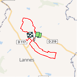
Ruta Senderismo de 6,8 km a descubrir en Nueva Aquitania, Lot y Garona, Lannes. Esta ruta ha sido propuesta por tracegps.
Descripción
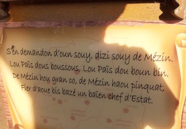
Si la première partie de ce circuit, au départ de la mairie de Lannes, est très ombragée, la seconde offre des points de vue plus lointains. Les vignes et des vergers de pruniers d’Ente sont présents au nord et au sud du circuit. Téléchargez la fiche de cette randonnée sur le site du Tourisme du Lot et Garonne.
Localización
Comentarios
Excursiones cerca
![Excursión Bici de montaña Mézin - Mézin, des jardins paysagers à la table d'orientation - Pays d'Albret - Photo](https://media.geolcdn.com/t/375/260/ext.jpg?maxdim=2&url=https%3A%2F%2Fservices.sitytrail.com%2FGeolivesWS%2FDownloadMedia.ashx%3FTrailID%3D110798%26Media%3D6294_1.jpg)
![Bici de montaña Bici de montaña](https://static1.geolcdn.com/sitytour/trail-icons/202.png)
Bici de montaña
![](/images/other/stat-length.png)
![](https://static1.geolcdn.com/siteimages/upload/files/16400158638029165_repeat_loop_refresh_sync_direction_icon.png)
![Excursión Bici de montaña Mézin - De Mézin, la Médiévale à Poudenas l'Italienne - Pays d'Albret - Photo](https://media.geolcdn.com/t/375/260/ext.jpg?maxdim=2&url=https%3A%2F%2Fservices.sitytrail.com%2FGeolivesWS%2FDownloadMedia.ashx%3FTrailID%3D110795%26Media%3D6293_1.jpg)
![Bici de montaña Bici de montaña](https://static1.geolcdn.com/sitytour/trail-icons/202.png)
Bici de montaña
![](/images/other/stat-length.png)
![](https://static1.geolcdn.com/siteimages/upload/files/16400158638029165_repeat_loop_refresh_sync_direction_icon.png)
![Excursión A pie Mézin - De Mézin à Villeneuve-de-Mézin, sur la route de Compostelle 16.6 km - Photo](https://media.geolcdn.com/t/375/260/ae5ee892-264d-47ca-b970-07ea0e883592.jpeg&format=jpg&maxdim=2)
![A pie A pie](https://static1.geolcdn.com/sitytour/trail-icons/100.png)
A pie
![](/images/other/stat-length.png)
![](https://static1.geolcdn.com/siteimages/upload/files/16400158638029165_repeat_loop_refresh_sync_direction_icon.png)
![Excursión A pie Mézin - Mézin, des jardins paysagers à la table d'orientation 4.8 km - Photo](https://media.geolcdn.com/t/375/260/ca3ca46d-f8e9-498b-bff7-554e5a603f77.jpeg&format=jpg&maxdim=2)
![A pie A pie](https://static1.geolcdn.com/sitytour/trail-icons/100.png)
A pie
![](/images/other/stat-length.png)
![](https://static1.geolcdn.com/siteimages/upload/files/16400158638029165_repeat_loop_refresh_sync_direction_icon.png)
![Excursión A pie Mézin - Mézin, des jardins paysagers à la table d'orientation variante 3.7 km km - Photo](https://media.geolcdn.com/t/375/260/ae5ee892-264d-47ca-b970-07ea0e883592.jpeg&format=jpg&maxdim=2)
![A pie A pie](https://static1.geolcdn.com/sitytour/trail-icons/100.png)
A pie
![](/images/other/stat-length.png)
![](https://static1.geolcdn.com/siteimages/upload/files/16400158638029165_repeat_loop_refresh_sync_direction_icon.png)
![Excursión A pie Lannes - De Lannes à Mézin, le parfum de l'Armagnac-Ténarèze 9.6 km - Photo](https://media.geolcdn.com/t/375/260/bf01d176-dfbc-4f74-9a32-be82b3416151.jpeg&format=jpg&maxdim=2)
![A pie A pie](https://static1.geolcdn.com/sitytour/trail-icons/100.png)
A pie
![](/images/other/stat-length.png)
![](https://static1.geolcdn.com/siteimages/upload/files/16400158638029165_repeat_loop_refresh_sync_direction_icon.png)
![Excursión Senderismo Mézin - Tustem boucle - Photo](https://media.geolcdn.com/t/375/260/00d33605-6b44-4947-b49e-1690659a9cf2.jpg&format=jpg&maxdim=2)
![Senderismo Senderismo](https://static1.geolcdn.com/sitytour/trail-icons/101.png)
Senderismo
![](/images/other/stat-length.png)
![](https://static1.geolcdn.com/siteimages/upload/files/16400158638029165_repeat_loop_refresh_sync_direction_icon.png)
![Excursión Senderismo Mézin - mezin-table d'orientation-la Porte Anglaise-Mezin - Photo](https://media.geolcdn.com/t/375/260/8d0516c5-05ca-43f6-a0c6-b1f4045ada44.jpg&format=jpg&maxdim=2)
![Senderismo Senderismo](https://static1.geolcdn.com/sitytour/trail-icons/101.png)
Senderismo
![](/images/other/stat-length.png)
![](https://static1.geolcdn.com/siteimages/upload/files/16400158638029165_repeat_loop_refresh_sync_direction_icon.png)
![Excursión A pie Lannes - Lannes, la balade de Gachot 6.9 km - Photo](https://media.geolcdn.com/t/375/260/bf01d176-dfbc-4f74-9a32-be82b3416151.jpeg&format=jpg&maxdim=2)
![A pie A pie](https://static1.geolcdn.com/sitytour/trail-icons/100.png)
A pie
![](/images/other/stat-length.png)
![](https://static1.geolcdn.com/siteimages/upload/files/16400158638029165_repeat_loop_refresh_sync_direction_icon.png)