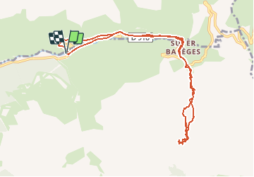
![](/images/other/stat-length.png)
![Excursión Raquetas de nieve Barèges - Crête de la Pègue - Barèges - Photo](https://media.geolcdn.com/t/1900/400/ext.pjpeg?maxdim=2&url=https%3A%2F%2Fservices.sitytrail.com%2FGeolivesWS%2FDownloadMedia.ashx%3FTrailID%3D317703%26Media%3D17005_6.jpg)
Crête de la Pègue - Barèges
tracegps
Usuario
![Longitud](/images/other/stat-length.png)
![Altitud máxima](https://static1.geolcdn.com/siteimages/upload/files/1508320355ic_sort_altitude_max_24dp.png)
![Desnivel positivo](https://static1.geolcdn.com/siteimages/upload/files/1508320355ic_sort_den_pos_24dp.png)
![Km-Effort](/images/other/stat-length.png)
![Altitud mínima](https://static1.geolcdn.com/siteimages/upload/files/1508320355ic_sort_altitude_min_24dp.png)
![Desnivel negativo](https://static1.geolcdn.com/siteimages/upload/files/1508320355ic_sort_den_neg_24dp.png)
![Boucle](https://static1.geolcdn.com/siteimages/upload/files/16400158638029165_repeat_loop_refresh_sync_direction_icon.png)
![Raquetas de nieve](https://static1.geolcdn.com/sitytour/trail-icons/504.png)
7h00
Dificultad : Difícil
![Escanee este código QR para abrir la excursión en la aplicación SityTrail](https://capi.geolives.com/qq0zvz2zws4bq2lad0pu/sitytour/trails/317703/qr.png?size=200)
Aplicación GPS de excursión GRATIS
A propósito
Ruta Raquetas de nieve de 10,8 km a descubrir en Occitania, Altos-Pirineos, Barèges. Esta ruta ha sido propuesta por tracegps.
Descripción
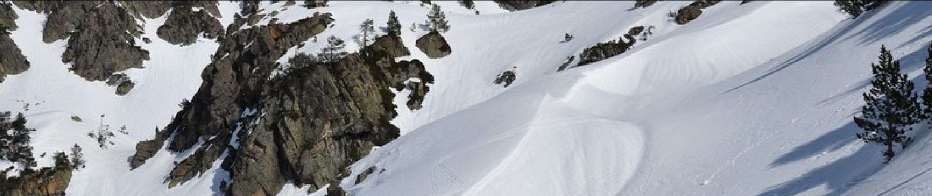
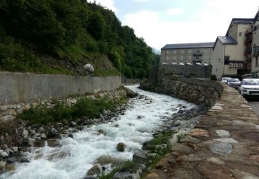
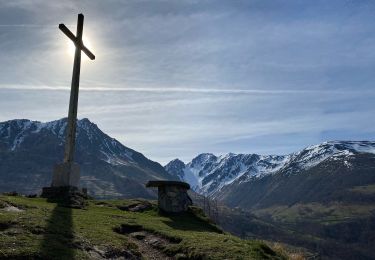
Départ du parking de Tournaboup à Barèges. On rejoint la station de Super-Barèges en longeant le vallon du ruisseau du Bastan. On traverse ensuite les pistes de skis pour attaquer la montée sévère par le vallon plein sud entre les pics de Campana et de Caoubère. De replat en replat, on arrive au sommet de la Crête d'où l'on domine, en contre-bas le vallon d'Aygues Cluzes et d'où on a une superbe vue sur les sommets environnants dont le Pic du Midi de Bigorre. Descente avec quelques variantes par le même vallon.
Localización
Comentarios
Excursiones cerca
![Excursión Senderismo Barèges - Pic des Trois Conseillers - Photo](https://media.geolcdn.com/t/375/260/ext.jpg?maxdim=2&url=https%3A%2F%2Fservices.sitytrail.com%2FGeolivesWS%2FDownloadMedia.ashx%3FTrailID%3D172698%26Media%3D14081_6.jpg)
![Senderismo Senderismo](https://static1.geolcdn.com/sitytour/trail-icons/101.png)
Senderismo
![](/images/other/stat-length.png)
![](https://static1.geolcdn.com/siteimages/upload/files/16400158638029165_repeat_loop_refresh_sync_direction_icon.png)
![Excursión Senderismo Barèges - Pic de Madamète en boucle par les lacs - Photo](https://media.geolcdn.com/t/375/260/ext.jpg?maxdim=2&url=https%3A%2F%2Fservices.sitytrail.com%2FGeolivesWS%2FDownloadMedia.ashx%3FTrailID%3D107077%26Media%3D11899_5.jpg)
![Senderismo Senderismo](https://static1.geolcdn.com/sitytour/trail-icons/101.png)
Senderismo
![](/images/other/stat-length.png)
![](https://static1.geolcdn.com/siteimages/upload/files/16400158638029165_repeat_loop_refresh_sync_direction_icon.png)
![Excursión Paseo ecuestre Sers - Plateau d’Aoube par la cabane d’Aoube - Photo](https://media.geolcdn.com/t/375/260/d0a193ac-ccc5-435d-ab72-b3f01c20ee9b.jpg&format=jpg&maxdim=2)
![Paseo ecuestre Paseo ecuestre](https://static1.geolcdn.com/sitytour/trail-icons/301.png)
Paseo ecuestre
![](/images/other/stat-length.png)
![](https://static1.geolcdn.com/siteimages/upload/files/16400158638029165_repeat_loop_refresh_sync_direction_icon.png)
![Excursión Senderismo Barèges - BAREGES le tour des plateaux G4 reco 3264577 - Photo](https://media.geolcdn.com/t/375/260/d3369853-4ed9-48c9-b0c7-23b9f6db24d3.jpg&format=jpg&maxdim=2)
![Senderismo Senderismo](https://static1.geolcdn.com/sitytour/trail-icons/101.png)
Senderismo
![](/images/other/stat-length.png)
![](https://static1.geolcdn.com/siteimages/upload/files/16400158638029165_repeat_loop_refresh_sync_direction_icon.png)
![Excursión Senderismo Bagnères-de-Bigorre - tourmalet G2 heit - Photo](https://media.geolcdn.com/t/375/260/8cd371a0-9f70-473d-b4f9-0ddefaeeb150.jpg&format=jpg&maxdim=2)
![Senderismo Senderismo](https://static1.geolcdn.com/sitytour/trail-icons/101.png)
Senderismo
![](/images/other/stat-length.png)
![](https://static1.geolcdn.com/siteimages/upload/files/16400158638029165_repeat_loop_refresh_sync_direction_icon.png)
![Excursión Senderismo Barèges - En boucle, Grand Tourmalet- Aygues Cluses-Col de Madamète- Lac Dets Coubous. - Photo](https://media.geolcdn.com/t/375/260/ext.jpg?maxdim=2&url=https%3A%2F%2Fstatic1.geolcdn.com%2Fsiteimages%2Fupload%2Ffiles%2F1553511878bg_sport_marche.png)
![Senderismo Senderismo](https://static1.geolcdn.com/sitytour/trail-icons/101.png)
Senderismo
![](/images/other/stat-length.png)
![](https://static1.geolcdn.com/siteimages/upload/files/16400158638029165_repeat_loop_refresh_sync_direction_icon.png)
![Excursión Senderismo Barèges - Bareges St Justin - Photo](https://media.geolcdn.com/t/375/260/1c3cf81f-9908-4ac1-bcb6-4709b37a0797.jpg&format=jpg&maxdim=2)
![Senderismo Senderismo](https://static1.geolcdn.com/sitytour/trail-icons/101.png)
Senderismo
![](/images/other/stat-length.png)
![](https://static1.geolcdn.com/siteimages/upload/files/16400158638029165_repeat_loop_refresh_sync_direction_icon.png)
![Excursión Senderismo Sers - BAREGES G4 le tour des plateaux](https://media.geolcdn.com/t/375/260/3b1a88cc-7c19-44dc-b1bc-bd751409e5bf.jpg&format=jpg&maxdim=2)
![Senderismo Senderismo](https://static1.geolcdn.com/sitytour/trail-icons/101.png)
Senderismo
![](/images/other/stat-length.png)
![](https://static1.geolcdn.com/siteimages/upload/files/16400158638029165_repeat_loop_refresh_sync_direction_icon.png)
![Excursión Senderismo Barèges - BAREGES le plateau des lumieres G3 fait](https://media.geolcdn.com/t/375/260/54fb900f-7849-4894-bd99-4b851200d9f6.jpg&format=jpg&maxdim=2)
![Senderismo Senderismo](https://static1.geolcdn.com/sitytour/trail-icons/101.png)
Senderismo
![](/images/other/stat-length.png)
![](https://static1.geolcdn.com/siteimages/upload/files/16400158638029165_repeat_loop_refresh_sync_direction_icon.png)