![](/images/other/stat-length.png)
![Excursión Bici de montaña Port-Jérôme-sur-Seine - Autour de Notre Dame de Gravenchon - Photo](https://media.geolcdn.com/t/1900/400/ext.pjpeg?maxdim=2&url=https%3A%2F%2Fservices.sitytrail.com%2FGeolivesWS%2FDownloadMedia.ashx%3FTrailID%3D317612%26Media%3D16881_4.jpg)
Autour de Notre Dame de Gravenchon
tracegps
Usuario
![Longitud](/images/other/stat-length.png)
Longitud
17,6 km
![Altitud máxima](https://static1.geolcdn.com/siteimages/upload/files/1508320355ic_sort_altitude_max_24dp.png)
Altitud máxima
146 m
![Desnivel positivo](https://static1.geolcdn.com/siteimages/upload/files/1508320355ic_sort_den_pos_24dp.png)
Desnivel positivo
397 m
![Km-Effort](/images/other/stat-length.png)
Km-Effort
23 km
![Altitud mínima](https://static1.geolcdn.com/siteimages/upload/files/1508320355ic_sort_altitude_min_24dp.png)
Altitud mínima
26 m
![Desnivel negativo](https://static1.geolcdn.com/siteimages/upload/files/1508320355ic_sort_den_neg_24dp.png)
Desnivel negativo
395 m
![Boucle](https://static1.geolcdn.com/siteimages/upload/files/16400158638029165_repeat_loop_refresh_sync_direction_icon.png)
Boucle
Sí
Fecha de creación :
2014-12-10 00:00:00.0
Última modificación :
2014-12-10 00:00:00.0
![Bici de montaña](https://static1.geolcdn.com/sitytour/trail-icons/202.png)
2h30
Dificultad : Difícil
![Escanee este código QR para abrir la excursión en la aplicación SityTrail](https://capi.geolives.com/qq0zvz2zws4bq2lad0pu/sitytour/trails/317612/qr.png?size=200)
Aplicación GPS de excursión GRATIS
A propósito
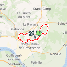
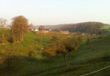
Ruta Bici de montaña de 17,6 km a descubrir en Normandía, Sena-Marítimo, Port-Jérôme-sur-Seine. Esta ruta ha sido propuesta por tracegps.
Descripción
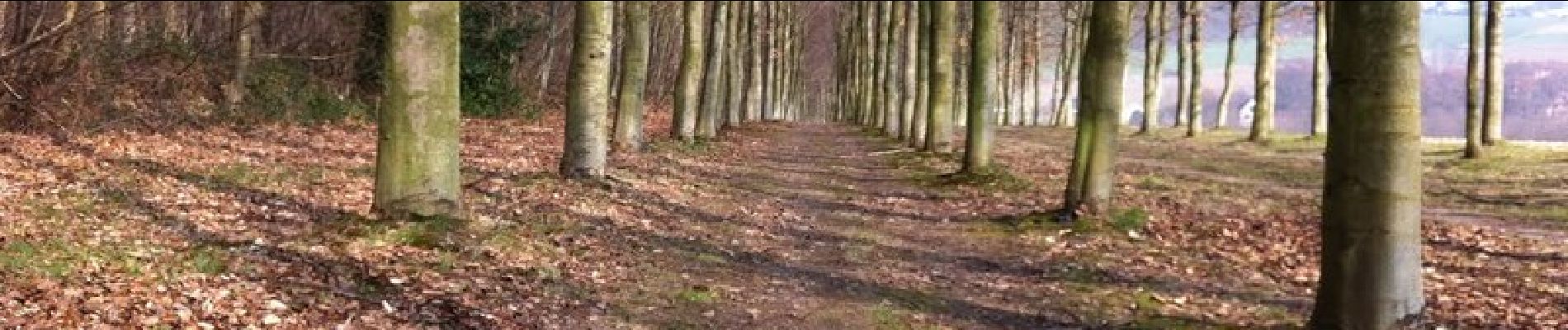
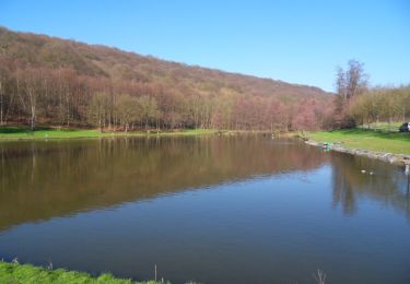
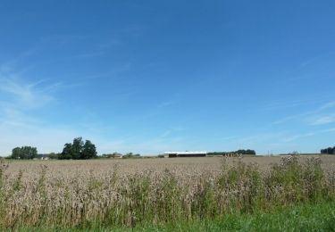
Ce circuit au départ des étangs du Théluet permet de découvrir Gravenchon à travers ses plaines et ses bois environnants. Joli Paysage au départ .
Localización
País:
France
Región :
Normandía
Departamento/provincia :
Sena-Marítimo
Municipio :
Port-Jérôme-sur-Seine
Localidad:
Notre-Dame-de-Gravenchon
Salida:(Dec)
Salida:(UTM)
325030 ; 5486028 (31U) N.
Comentarios
Excursiones cerca
![Excursión Caballo Port-Jérôme-sur-Seine - comtes d'evreux - Photo](https://media.geolcdn.com/t/375/260/ext.jpg?maxdim=2&url=https%3A%2F%2Fstatic1.geolcdn.com%2Fsiteimages%2Fupload%2Ffiles%2F1524743154cheval.jpg)
![Caballo Caballo](https://static1.geolcdn.com/sitytour/trail-icons/300.png)
comtes d'evreux
Caballo
Muy fácil
(1)
Port-Jérôme-sur-Seine,
Normandía,
Sena-Marítimo,
France
![](/images/other/stat-length.png)
24 km | 29 km-effort
Desconocido
![](https://static1.geolcdn.com/siteimages/upload/files/16400158638029165_repeat_loop_refresh_sync_direction_icon.png)
Sí
![Excursión Caballo Port-Jérôme-sur-Seine - Autour de Notre Dame de Gravenchon - Photo](https://media.geolcdn.com/t/375/260/ext.jpg?maxdim=2&url=https%3A%2F%2Fservices.sitytrail.com%2FGeolivesWS%2FDownloadMedia.ashx%3FTrailID%3D317613%26Media%3D16881_1.jpg)
![Caballo Caballo](https://static1.geolcdn.com/sitytour/trail-icons/300.png)
Autour de Notre Dame de Gravenchon
Caballo
Difícil
Port-Jérôme-sur-Seine,
Normandía,
Sena-Marítimo,
France
![](/images/other/stat-length.png)
17,6 km | 23 km-effort
2h 45min
![](https://static1.geolcdn.com/siteimages/upload/files/16400158638029165_repeat_loop_refresh_sync_direction_icon.png)
Sí
![Excursión Caballo Port-Jérôme-sur-Seine - Autour de Triquerville à Cheval - Photo](https://media.geolcdn.com/t/375/260/ext.jpg?maxdim=2&url=https%3A%2F%2Fservices.sitytrail.com%2FGeolivesWS%2FDownloadMedia.ashx%3FTrailID%3D317545%26Media%3D16795_3.jpg)
![Caballo Caballo](https://static1.geolcdn.com/sitytour/trail-icons/300.png)
Autour de Triquerville à Cheval
Caballo
Medio
Port-Jérôme-sur-Seine,
Normandía,
Sena-Marítimo,
France
![](/images/other/stat-length.png)
16,6 km | 20 km-effort
2h 30min
![](https://static1.geolcdn.com/siteimages/upload/files/16400158638029165_repeat_loop_refresh_sync_direction_icon.png)
Sí
![Excursión Bici de montaña Port-Jérôme-sur-Seine - Autour de Triquerville à Cheval - Photo](https://media.geolcdn.com/t/375/260/ext.jpg?maxdim=2&url=https%3A%2F%2Fservices.sitytrail.com%2FGeolivesWS%2FDownloadMedia.ashx%3FTrailID%3D317544%26Media%3D16795_3.jpg)
![Bici de montaña Bici de montaña](https://static1.geolcdn.com/sitytour/trail-icons/202.png)
Autour de Triquerville à Cheval
Bici de montaña
Medio
Port-Jérôme-sur-Seine,
Normandía,
Sena-Marítimo,
France
![](/images/other/stat-length.png)
16,6 km | 20 km-effort
1h 30min
![](https://static1.geolcdn.com/siteimages/upload/files/16400158638029165_repeat_loop_refresh_sync_direction_icon.png)
Sí
![Excursión Senderismo Norville - Randonnée autour de Norville - Photo](https://media.geolcdn.com/t/375/260/ext.jpg?maxdim=2&url=https%3A%2F%2Fservices.sitytrail.com%2FGeolivesWS%2FDownloadMedia.ashx%3FTrailID%3D107040%26Media%3D11847_1.jpg)
![Senderismo Senderismo](https://static1.geolcdn.com/sitytour/trail-icons/101.png)
Randonnée autour de Norville
Senderismo
Medio
(1)
Norville,
Normandía,
Sena-Marítimo,
France
![](/images/other/stat-length.png)
13,4 km | 15,5 km-effort
2h 30min
![](https://static1.geolcdn.com/siteimages/upload/files/16400158638029165_repeat_loop_refresh_sync_direction_icon.png)
No
![Excursión Senderismo Port-Jérôme-sur-Seine - port jerome sur seine - Photo](https://media.geolcdn.com/t/375/260/ext.jpg?maxdim=2&url=https%3A%2F%2Fstatic1.geolcdn.com%2Fsiteimages%2Fupload%2Ffiles%2F1553511878bg_sport_marche.png)
![Senderismo Senderismo](https://static1.geolcdn.com/sitytour/trail-icons/101.png)
port jerome sur seine
Senderismo
Medio
Port-Jérôme-sur-Seine,
Normandía,
Sena-Marítimo,
France
![](/images/other/stat-length.png)
13 km | 17,2 km-effort
3h 20min
![](https://static1.geolcdn.com/siteimages/upload/files/16400158638029165_repeat_loop_refresh_sync_direction_icon.png)
Sí
![Excursión Senderismo Rives-en-Seine - Bébec les sources (Villequier) 139 - Photo](https://media.geolcdn.com/t/375/260/ext.jpg?maxdim=2&url=https%3A%2F%2Fstatic1.geolcdn.com%2Fsiteimages%2Fupload%2Ffiles%2F1553511878bg_sport_marche.png)
![Senderismo Senderismo](https://static1.geolcdn.com/sitytour/trail-icons/101.png)
Bébec les sources (Villequier) 139
Senderismo
Difícil
Rives-en-Seine,
Normandía,
Sena-Marítimo,
France
![](/images/other/stat-length.png)
11,4 km | 14 km-effort
3h 11min
![](https://static1.geolcdn.com/siteimages/upload/files/16400158638029165_repeat_loop_refresh_sync_direction_icon.png)
Sí
![Excursión Senderismo Port-Jérôme-sur-Seine - Triquervlle 2022 10 24 - Photo](https://media.geolcdn.com/t/375/260/ext.jpg?maxdim=2&url=https%3A%2F%2Fstatic1.geolcdn.com%2Fsiteimages%2Fupload%2Ffiles%2F1553511878bg_sport_marche.png)
![Senderismo Senderismo](https://static1.geolcdn.com/sitytour/trail-icons/101.png)
Triquervlle 2022 10 24
Senderismo
Medio
Port-Jérôme-sur-Seine,
Normandía,
Sena-Marítimo,
France
![](/images/other/stat-length.png)
20 km | 25 km-effort
5h 9min
![](https://static1.geolcdn.com/siteimages/upload/files/16400158638029165_repeat_loop_refresh_sync_direction_icon.png)
Sí
![Excursión Senderismo Rives-en-Seine - bebec le 6 10 - Photo](https://media.geolcdn.com/t/375/260/ext.jpg?maxdim=2&url=https%3A%2F%2Fstatic1.geolcdn.com%2Fsiteimages%2Fupload%2Ffiles%2F1553511878bg_sport_marche.png)
![Senderismo Senderismo](https://static1.geolcdn.com/sitytour/trail-icons/101.png)
bebec le 6 10
Senderismo
Difícil
(1)
Rives-en-Seine,
Normandía,
Sena-Marítimo,
France
![](/images/other/stat-length.png)
10,4 km | 12,5 km-effort
2h 46min
![](https://static1.geolcdn.com/siteimages/upload/files/16400158638029165_repeat_loop_refresh_sync_direction_icon.png)
Sí