![](/images/other/stat-length.png)
![Excursión Bici de montaña Lasse - Le Sentier des Contrebandiers en VTT - De St Jean Pied de Port à Espila - Photo](https://media.geolcdn.com/t/1900/400/ext.pjpeg?maxdim=2&url=https%3A%2F%2Fservices.sitytrail.com%2FGeolivesWS%2FDownloadMedia.ashx%3FTrailID%3D317575%26Media%3D16834_1.jpg)
Le Sentier des Contrebandiers en VTT - De St Jean Pied de Port à Espila
tracegps
Usuario
![Longitud](/images/other/stat-length.png)
![Altitud máxima](https://static1.geolcdn.com/siteimages/upload/files/1508320355ic_sort_altitude_max_24dp.png)
![Desnivel positivo](https://static1.geolcdn.com/siteimages/upload/files/1508320355ic_sort_den_pos_24dp.png)
![Km-Effort](/images/other/stat-length.png)
![Altitud mínima](https://static1.geolcdn.com/siteimages/upload/files/1508320355ic_sort_altitude_min_24dp.png)
![Desnivel negativo](https://static1.geolcdn.com/siteimages/upload/files/1508320355ic_sort_den_neg_24dp.png)
![Boucle](https://static1.geolcdn.com/siteimages/upload/files/16400158638029165_repeat_loop_refresh_sync_direction_icon.png)
![Bici de montaña](https://static1.geolcdn.com/sitytour/trail-icons/202.png)
4h00
Dificultad : Difícil
![Escanee este código QR para abrir la excursión en la aplicación SityTrail](https://capi.geolives.com/qq0zvz2zws4bq2lad0pu/sitytour/trails/317575/qr.png?size=200)
Aplicación GPS de excursión GRATIS
A propósito
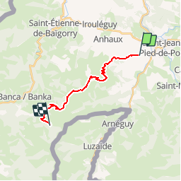
Ruta Bici de montaña de 15,7 km a descubrir en Nueva Aquitania, Pirineos-Atlánticos, Lasse. Esta ruta ha sido propuesta por tracegps.
Descripción
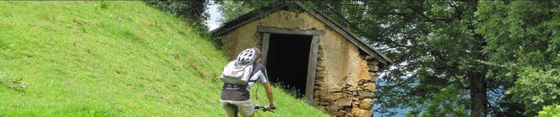
Il est des endroits où, parfois, il faut savoir profiter de l’environnement afin de mieux goûter, mieux percevoir, mieux apprécier l’univers montagnard avec tout ce qu’il englobe. Après avoir traversé les plaines et coteaux basques, une halte à la ferme Espil, sur les hauteurs de Banca, permet d’avoir une vision plus large de notre pays, d’effectuer une coupure avec la ville lors d’une nuitée la haut… Expérience très agréable. Auparavant, malgré une bonne montée, la vue du Monhoa et sa descente dans les estives en ravira plus d’un. Plus de détail sur le Sentier des Contrebandiers en VTT .
Localización
Comentarios
Excursiones cerca
![Excursión Senderismo San Juan Pie de Puerto - C3.2 St Jean - Roncevaux - Photo](https://media.geolcdn.com/t/375/260/ext.jpg?maxdim=2&url=https%3A%2F%2Fservices.sitytrail.com%2FGeolivesWS%2FDownloadMedia.ashx%3FTrailID%3D202964%26Media%3Df4f6583b-22a3-4bf3-b263-f7ca0aca1565.jpg)
![Senderismo Senderismo](https://static1.geolcdn.com/sitytour/trail-icons/101.png)
Senderismo
![](/images/other/stat-length.png)
![](https://static1.geolcdn.com/siteimages/upload/files/16400158638029165_repeat_loop_refresh_sync_direction_icon.png)
![Excursión Senderismo Ispoure - arradoy G4Fait - Photo](https://media.geolcdn.com/t/375/260/b1d4f481-6895-478c-81f3-6ef884c4075d.jpg&format=jpg&maxdim=2)
![Senderismo Senderismo](https://static1.geolcdn.com/sitytour/trail-icons/101.png)
Senderismo
![](/images/other/stat-length.png)
![](https://static1.geolcdn.com/siteimages/upload/files/16400158638029165_repeat_loop_refresh_sync_direction_icon.png)
![Excursión Marcha nórdica Çaro - Col d'Irey ou Tour du pic d'Iramendy - Photo](https://media.geolcdn.com/t/375/260/ext.jpg?maxdim=2&url=https%3A%2F%2Fstatic1.geolcdn.com%2Fsiteimages%2Fupload%2Ffiles%2F1545311037marcheuse_200dpi.jpg)
![Marcha nórdica Marcha nórdica](https://static1.geolcdn.com/sitytour/trail-icons/102.png)
Marcha nórdica
![](/images/other/stat-length.png)
![](https://static1.geolcdn.com/siteimages/upload/files/16400158638029165_repeat_loop_refresh_sync_direction_icon.png)
![Excursión Senderismo Ispoure - Arradoy - Photo](https://media.geolcdn.com/t/375/260/ext.jpg?maxdim=2&url=https%3A%2F%2Fstatic1.geolcdn.com%2Fsiteimages%2Fupload%2Ffiles%2F1553511878bg_sport_marche.png)
![Senderismo Senderismo](https://static1.geolcdn.com/sitytour/trail-icons/101.png)
Senderismo
![](/images/other/stat-length.png)
![](https://static1.geolcdn.com/siteimages/upload/files/16400158638029165_repeat_loop_refresh_sync_direction_icon.png)
![Excursión Senderismo San Juan Pie de Puerto - 2023 10 14 CHEMIN du PIÉMONT PYRÉNÉEN - 22ème étape : Saint-Jean-Pied-De-Port - Honto - Col Lepœder - Roncesvalles - Photo](https://media.geolcdn.com/t/375/260/a6305f35-d93b-4cf3-9c13-a015d8460915.jpg&format=jpg&maxdim=2)
![Senderismo Senderismo](https://static1.geolcdn.com/sitytour/trail-icons/101.png)
Senderismo
![](/images/other/stat-length.png)
![](https://static1.geolcdn.com/siteimages/upload/files/16400158638029165_repeat_loop_refresh_sync_direction_icon.png)
![Excursión Senderismo Ispoure - Arradoy - Photo](https://media.geolcdn.com/t/375/260/dad09f6b-17f2-454c-80e0-b56c173ff2a7.jpg&format=jpg&maxdim=2)
![Senderismo Senderismo](https://static1.geolcdn.com/sitytour/trail-icons/101.png)
Senderismo
![](/images/other/stat-length.png)
![](https://static1.geolcdn.com/siteimages/upload/files/16400158638029165_repeat_loop_refresh_sync_direction_icon.png)
![Excursión Senderismo San Juan Pie de Puerto - Saint-Jean-Pied-de-Port Gr 65 - Photo](https://media.geolcdn.com/t/375/260/be1151ba-0eae-47f2-a1b3-ca8e7b17585f.jpg&format=jpg&maxdim=2)
![Senderismo Senderismo](https://static1.geolcdn.com/sitytour/trail-icons/101.png)
Senderismo
![](/images/other/stat-length.png)
![](https://static1.geolcdn.com/siteimages/upload/files/16400158638029165_repeat_loop_refresh_sync_direction_icon.png)
![Excursión Senderismo San Juan Pie de Puerto - Saint-Jean-Pied-de-Port, la citadelle - Photo](https://media.geolcdn.com/t/375/260/713cbf20-81b6-4133-bdc9-cae24b6f18c3.jpg&format=jpg&maxdim=2)
![Senderismo Senderismo](https://static1.geolcdn.com/sitytour/trail-icons/101.png)
Senderismo
![](/images/other/stat-length.png)
![](https://static1.geolcdn.com/siteimages/upload/files/16400158638029165_repeat_loop_refresh_sync_direction_icon.png)
![Excursión Senderismo Jaxu - Du camping Borda Lodge - Jaxu - Photo](https://media.geolcdn.com/t/375/260/33178a4b-e28c-433d-a37b-8028b3ad6e08.jpg&format=jpg&maxdim=2)
![Senderismo Senderismo](https://static1.geolcdn.com/sitytour/trail-icons/101.png)
Senderismo
![](/images/other/stat-length.png)
![](https://static1.geolcdn.com/siteimages/upload/files/16400158638029165_repeat_loop_refresh_sync_direction_icon.png)