![](/images/other/stat-length.png)
![Excursión Senderismo Pouzilhac - Le Serre du Cabrol - Pouzilhac - Photo](https://media.geolcdn.com/t/1900/400/ext.pjpeg?maxdim=2&url=https%3A%2F%2Fservices.sitytrail.com%2FGeolivesWS%2FDownloadMedia.ashx%3FTrailID%3D317464%26Media%3D16697_4.jpg)
Le Serre du Cabrol - Pouzilhac
tracegps
Usuario
![Longitud](/images/other/stat-length.png)
![Altitud máxima](https://static1.geolcdn.com/siteimages/upload/files/1508320355ic_sort_altitude_max_24dp.png)
![Desnivel positivo](https://static1.geolcdn.com/siteimages/upload/files/1508320355ic_sort_den_pos_24dp.png)
![Km-Effort](/images/other/stat-length.png)
![Altitud mínima](https://static1.geolcdn.com/siteimages/upload/files/1508320355ic_sort_altitude_min_24dp.png)
![Desnivel negativo](https://static1.geolcdn.com/siteimages/upload/files/1508320355ic_sort_den_neg_24dp.png)
![Boucle](https://static1.geolcdn.com/siteimages/upload/files/16400158638029165_repeat_loop_refresh_sync_direction_icon.png)
![Senderismo](https://static1.geolcdn.com/sitytour/trail-icons/101.png)
4h00
Dificultad : Difícil
![Escanee este código QR para abrir la excursión en la aplicación SityTrail](https://capi.geolives.com/qq0zvz2zws4bq2lad0pu/sitytour/trails/317464/qr.png?size=200)
Aplicación GPS de excursión GRATIS
A propósito
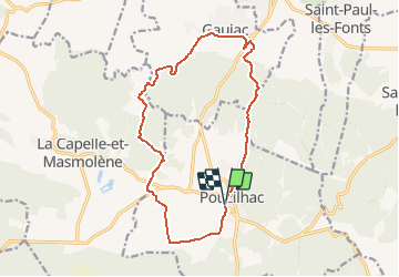
Ruta Senderismo de 15,9 km a descubrir en Occitania, Gard, Pouzilhac. Esta ruta ha sido propuesta por tracegps.
Descripción
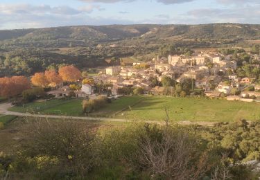
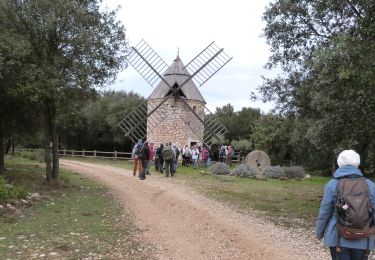
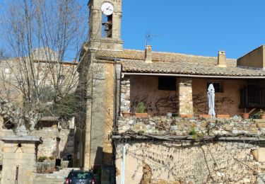
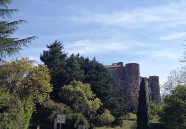
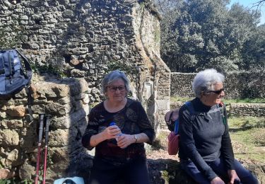
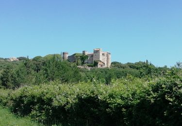
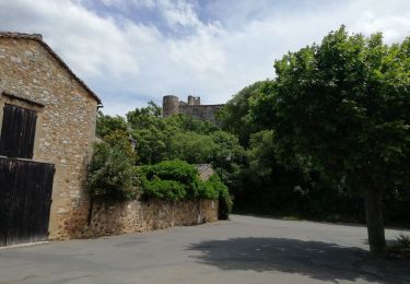
Circuit entre vignes et forêts de garrigues ou de châtaigniers, entre calcaires et gneiss. Parking en bas du village (D101 ou remparts du village). D'abord au sud puis l'ouest vers Panely, quitter les vignes pour monter au Serre de Cabrol et traverser une forêt de châtaigniers. Rejoindre La Veyre puis Gaujac avant de remonter à Pouzilhac. Bonne balade.
Localización
Comentarios
Excursiones cerca
![Excursión Senderismo Pouzilhac - Le sentier botanique - Pouzilhac - Photo](https://media.geolcdn.com/t/375/260/ext.jpg?maxdim=2&url=https%3A%2F%2Fservices.sitytrail.com%2FGeolivesWS%2FDownloadMedia.ashx%3FTrailID%3D317463%26Media%3D16695_6.jpg)
![Senderismo Senderismo](https://static1.geolcdn.com/sitytour/trail-icons/101.png)
Senderismo
![](/images/other/stat-length.png)
![](https://static1.geolcdn.com/siteimages/upload/files/16400158638029165_repeat_loop_refresh_sync_direction_icon.png)
![Excursión Senderismo Valliguières - Valliguières - St Pierre - Solidarité - Photo](https://media.geolcdn.com/t/375/260/34c7644f-964a-475b-8438-72b62b10d114.jpg&format=jpg&maxdim=2)
![Senderismo Senderismo](https://static1.geolcdn.com/sitytour/trail-icons/101.png)
Senderismo
![](/images/other/stat-length.png)
![](https://static1.geolcdn.com/siteimages/upload/files/16400158638029165_repeat_loop_refresh_sync_direction_icon.png)
![Excursión Senderismo Valliguières - Valliguières - Etang - St Pierre - Photo](https://media.geolcdn.com/t/375/260/34c7644f-964a-475b-8438-72b62b10d114.jpg&format=jpg&maxdim=2)
![Senderismo Senderismo](https://static1.geolcdn.com/sitytour/trail-icons/101.png)
Senderismo
![](/images/other/stat-length.png)
![](https://static1.geolcdn.com/siteimages/upload/files/16400158638029165_repeat_loop_refresh_sync_direction_icon.png)
![Senderismo Senderismo](https://static1.geolcdn.com/sitytour/trail-icons/101.png)
Senderismo
![](/images/other/stat-length.png)
![](https://static1.geolcdn.com/siteimages/upload/files/16400158638029165_repeat_loop_refresh_sync_direction_icon.png)
![Excursión Senderismo La Capelle-et-Masmolène - La Capelle-et-Masmolène - Photo](https://media.geolcdn.com/t/375/260/f4bee39f-4c39-4cab-8a93-6bf86aad1227.jpg&format=jpg&maxdim=2)
![Senderismo Senderismo](https://static1.geolcdn.com/sitytour/trail-icons/101.png)
Senderismo
![](/images/other/stat-length.png)
![](https://static1.geolcdn.com/siteimages/upload/files/16400158638029165_repeat_loop_refresh_sync_direction_icon.png)
![Excursión Senderismo La Capelle-et-Masmolène - la Capelle Masmolène - Photo](https://media.geolcdn.com/t/375/260/bef0fd11-cf52-40d2-a314-8a457cce1486.jpg&format=jpg&maxdim=2)
![Senderismo Senderismo](https://static1.geolcdn.com/sitytour/trail-icons/101.png)
Senderismo
![](/images/other/stat-length.png)
![](https://static1.geolcdn.com/siteimages/upload/files/16400158638029165_repeat_loop_refresh_sync_direction_icon.png)
![Excursión Senderismo Gaujac - Gaujac 160323 - Photo](https://media.geolcdn.com/t/375/260/439ce872-f270-4bfe-a0e1-c0bcc7ef5229.jpg&format=jpg&maxdim=2)
![Senderismo Senderismo](https://static1.geolcdn.com/sitytour/trail-icons/101.png)
![Excursión Bici de montaña La Capelle-et-Masmolène - 30-vtt-lacapelle-St-Siffret-25km-230m-juin21 - Photo](https://media.geolcdn.com/t/375/260/74209226-475f-4318-8632-2d86913fe9b4.jpg&format=jpg&maxdim=2)
![Bici de montaña Bici de montaña](https://static1.geolcdn.com/sitytour/trail-icons/202.png)
Bici de montaña
![](/images/other/stat-length.png)
![](https://static1.geolcdn.com/siteimages/upload/files/16400158638029165_repeat_loop_refresh_sync_direction_icon.png)
![Excursión Senderismo La Capelle-et-Masmolène - 30-lacapelle-forets-15km-240m-juin21 - Photo](https://media.geolcdn.com/t/375/260/095ee961-8922-44c2-8466-9aac36f833dd.jpg&format=jpg&maxdim=2)
![Senderismo Senderismo](https://static1.geolcdn.com/sitytour/trail-icons/101.png)
Senderismo
![](/images/other/stat-length.png)
![](https://static1.geolcdn.com/siteimages/upload/files/16400158638029165_repeat_loop_refresh_sync_direction_icon.png)