![](/images/other/stat-length.png)
![Excursión Senderismo Crancey - Entre CRANCEY et PONT SUR SEINE - Photo](https://media.geolcdn.com/t/1900/400/ext.pjpeg?maxdim=2&url=https%3A%2F%2Fmedia.geolcdn.com%2Ff%2F57d0ce4e-2aa7-4ecd-8bc9-3fd6665e20d8.jpg)
Entre CRANCEY et PONT SUR SEINE
jeannine grandjean
Usuario
![Longitud](/images/other/stat-length.png)
Longitud
10,2 km
![Altitud máxima](https://static1.geolcdn.com/siteimages/upload/files/1508320355ic_sort_altitude_max_24dp.png)
Altitud máxima
114 m
![Desnivel positivo](https://static1.geolcdn.com/siteimages/upload/files/1508320355ic_sort_den_pos_24dp.png)
Desnivel positivo
92 m
![Km-Effort](/images/other/stat-length.png)
Km-Effort
11,5 km
![Altitud mínima](https://static1.geolcdn.com/siteimages/upload/files/1508320355ic_sort_altitude_min_24dp.png)
Altitud mínima
63 m
![Desnivel negativo](https://static1.geolcdn.com/siteimages/upload/files/1508320355ic_sort_den_neg_24dp.png)
Desnivel negativo
92 m
![Boucle](https://static1.geolcdn.com/siteimages/upload/files/16400158638029165_repeat_loop_refresh_sync_direction_icon.png)
Boucle
Sí
Fecha de creación :
2022-03-18 13:14:28.359
Última modificación :
2022-03-30 13:26:05.403
![Senderismo](https://static1.geolcdn.com/sitytour/trail-icons/101.png)
2h25
Dificultad : Medio
![Escanee este código QR para abrir la excursión en la aplicación SityTrail](https://capi.geolives.com/qq0zvz2zws4bq2lad0pu/sitytour/trails/3171555/qr.png?size=200)
Aplicación GPS de excursión GRATIS
A propósito
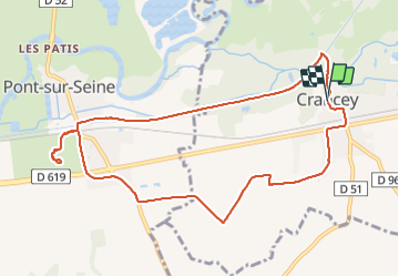
Ruta Senderismo de 10,2 km a descubrir en Gran Este, Aube, Crancey. Esta ruta ha sido propuesta por jeannine grandjean.
Descripción
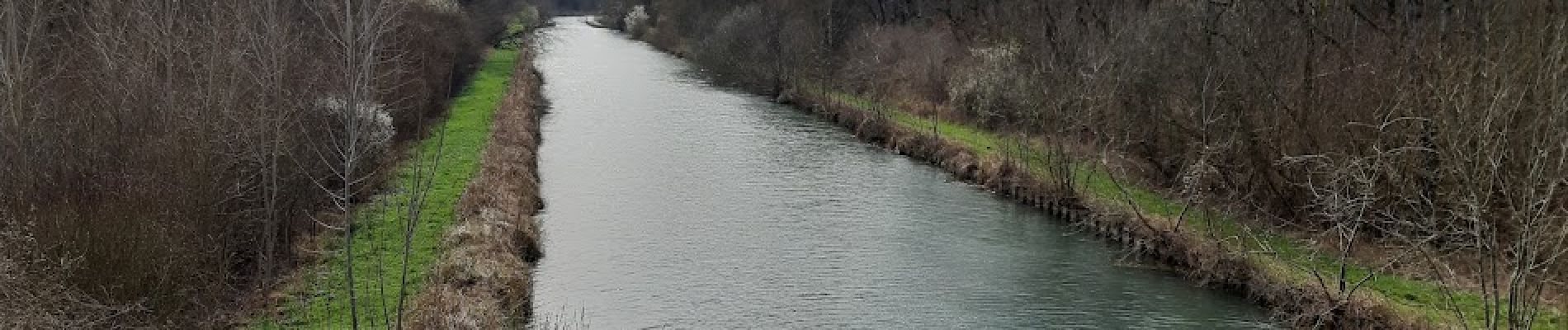
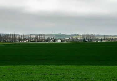
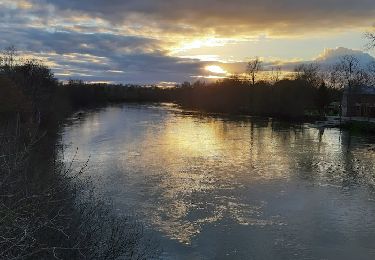
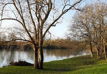
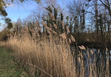
découverte de la Seine et du canal de dérivation de Bernières à Conflans. On passe sur le pont canal et on arrive à PONT SUR SEINE où l'on traverse le canal sur un pont-levis. Retour à travers champs jusqu'à Crancey
Localización
País:
France
Región :
Gran Este
Departamento/provincia :
Aube
Municipio :
Crancey
Localidad:
Unknown
Salida:(Dec)
Salida:(UTM)
547059 ; 5373973 (31U) N.
Comentarios
Excursiones cerca
![Excursión Senderismo Gélannes - GÉLANNES, le village et les champs de céréales - Photo](https://media.geolcdn.com/t/375/260/ext.jpg?maxdim=2&url=https%3A%2F%2Fmedia.geolcdn.com%2Ff%2Fc6ca0f5d-851c-4470-96c9-b68dee3e35f0.jpg)
![Senderismo Senderismo](https://static1.geolcdn.com/sitytour/trail-icons/101.png)
GÉLANNES, le village et les champs de céréales
Senderismo
Medio
(1)
Gélannes,
Gran Este,
Aube,
France
![](/images/other/stat-length.png)
10 km | 11,4 km-effort
2h 34min
![](https://static1.geolcdn.com/siteimages/upload/files/16400158638029165_repeat_loop_refresh_sync_direction_icon.png)
Sí
![Excursión Senderismo Pont-sur-Seine - entre Pont sur SEINE et MARNAY - Photo](https://media.geolcdn.com/t/375/260/ext.jpg?maxdim=2&url=https%3A%2F%2Fmedia.geolcdn.com%2Ff%2Ff3468e01-ffe2-4948-a269-d888243d04a3.webloc)
![Senderismo Senderismo](https://static1.geolcdn.com/sitytour/trail-icons/101.png)
entre Pont sur SEINE et MARNAY
Senderismo
Difícil
(1)
Pont-sur-Seine,
Gran Este,
Aube,
France
![](/images/other/stat-length.png)
13,1 km | 13,8 km-effort
2h 43min
![](https://static1.geolcdn.com/siteimages/upload/files/16400158638029165_repeat_loop_refresh_sync_direction_icon.png)
Sí
![Excursión Senderismo Conflans-sur-Seine - ENTRE CONFLANS SUR SEINE ET MARCILLY SUR SEINE - Photo](https://media.geolcdn.com/t/375/260/ext.jpg?maxdim=2&url=https%3A%2F%2Fmedia.geolcdn.com%2Ff%2F28379627-7295-4da2-9e32-ab26d90c9cc8.jpg)
![Senderismo Senderismo](https://static1.geolcdn.com/sitytour/trail-icons/101.png)
ENTRE CONFLANS SUR SEINE ET MARCILLY SUR SEINE
Senderismo
Medio
Conflans-sur-Seine,
Gran Este,
Marne,
France
![](/images/other/stat-length.png)
10,7 km | 11,7 km-effort
2h 39min
![](https://static1.geolcdn.com/siteimages/upload/files/16400158638029165_repeat_loop_refresh_sync_direction_icon.png)
Sí
![Excursión Senderismo Conflans-sur-Seine - au départ de CONFLANS sur SEINE - Photo](https://media.geolcdn.com/t/375/260/ext.jpg?maxdim=2&url=https%3A%2F%2Fmedia.geolcdn.com%2Ff%2F80485f03-17f7-4558-8dfe-6e48f8164773.jpg)
![Senderismo Senderismo](https://static1.geolcdn.com/sitytour/trail-icons/101.png)
au départ de CONFLANS sur SEINE
Senderismo
Fácil
Conflans-sur-Seine,
Gran Este,
Marne,
France
![](/images/other/stat-length.png)
15,7 km | 17,5 km-effort
3h 17min
![](https://static1.geolcdn.com/siteimages/upload/files/16400158638029165_repeat_loop_refresh_sync_direction_icon.png)
No
![Excursión Senderismo Gélannes - Boucle Gelannes Pomereau - Photo](https://media.geolcdn.com/t/375/260/ext.jpg?maxdim=2&url=https%3A%2F%2Fmedia.geolcdn.com%2Ff%2F279b6d41-6397-4ecc-b6aa-20b3afadd4e3.jpg)
![Senderismo Senderismo](https://static1.geolcdn.com/sitytour/trail-icons/101.png)
Boucle Gelannes Pomereau
Senderismo
Muy fácil
Gélannes,
Gran Este,
Aube,
France
![](/images/other/stat-length.png)
11,9 km | 13,9 km-effort
2h 25min
![](https://static1.geolcdn.com/siteimages/upload/files/16400158638029165_repeat_loop_refresh_sync_direction_icon.png)
Sí
![Excursión Senderismo Pont-sur-Seine - De Pont sur Seine à Marnay - Photo](https://media.geolcdn.com/t/375/260/ext.jpg?maxdim=2&url=https%3A%2F%2Fmedia.geolcdn.com%2Ff%2F381e93b8-caf4-43dd-ac99-d1509d92dd1f.jpg)
![Senderismo Senderismo](https://static1.geolcdn.com/sitytour/trail-icons/101.png)
De Pont sur Seine à Marnay
Senderismo
Fácil
(1)
Pont-sur-Seine,
Gran Este,
Aube,
France
![](/images/other/stat-length.png)
13,4 km | 14,1 km-effort
2h 38min
![](https://static1.geolcdn.com/siteimages/upload/files/16400158638029165_repeat_loop_refresh_sync_direction_icon.png)
Sí
![Excursión Senderismo Esclavolles-Lurey - Boucle Esclavoles Perigny les éoliennes - Photo](https://media.geolcdn.com/t/375/260/ext.jpg?maxdim=2&url=https%3A%2F%2Fstatic1.geolcdn.com%2Fsiteimages%2Fupload%2Ffiles%2F1553511878bg_sport_marche.png)
![Senderismo Senderismo](https://static1.geolcdn.com/sitytour/trail-icons/101.png)
Boucle Esclavoles Perigny les éoliennes
Senderismo
Fácil
Esclavolles-Lurey,
Gran Este,
Marne,
France
![](/images/other/stat-length.png)
12,6 km | 14,1 km-effort
2h 55min
![](https://static1.geolcdn.com/siteimages/upload/files/16400158638029165_repeat_loop_refresh_sync_direction_icon.png)
Sí
![Excursión Senderismo Conflans-sur-Seine - Autour de Conflans et Esclavoles - Photo](https://media.geolcdn.com/t/375/260/ext.jpg?maxdim=2&url=https%3A%2F%2Fstatic1.geolcdn.com%2Fsiteimages%2Fupload%2Ffiles%2F1553511878bg_sport_marche.png)
![Senderismo Senderismo](https://static1.geolcdn.com/sitytour/trail-icons/101.png)
Autour de Conflans et Esclavoles
Senderismo
Muy fácil
Conflans-sur-Seine,
Gran Este,
Marne,
France
![](/images/other/stat-length.png)
9,7 km | 10,6 km-effort
1h 53min
![](https://static1.geolcdn.com/siteimages/upload/files/16400158638029165_repeat_loop_refresh_sync_direction_icon.png)
Sí
![Excursión Senderismo Gélannes - Boucle Gélannes - Photo](https://media.geolcdn.com/t/375/260/ext.jpg?maxdim=2&url=https%3A%2F%2Fstatic1.geolcdn.com%2Fsiteimages%2Fupload%2Ffiles%2F1553511878bg_sport_marche.png)
![Senderismo Senderismo](https://static1.geolcdn.com/sitytour/trail-icons/101.png)