![](/images/other/stat-length.png)
![Excursión Senderismo Perros-Guirec - Le Sentier des Douaniers à Perros-Guirec - Photo](https://media.geolcdn.com/t/1900/400/ext.pjpeg?maxdim=2&url=https%3A%2F%2Fservices.sitytrail.com%2FGeolivesWS%2FDownloadMedia.ashx%3FTrailID%3D317020%26Media%3D16162_5.jpg)
Le Sentier des Douaniers à Perros-Guirec
tracegps
Usuario
![Longitud](/images/other/stat-length.png)
Longitud
8,1 km
![Altitud máxima](https://static1.geolcdn.com/siteimages/upload/files/1508320355ic_sort_altitude_max_24dp.png)
Altitud máxima
59 m
![Desnivel positivo](https://static1.geolcdn.com/siteimages/upload/files/1508320355ic_sort_den_pos_24dp.png)
Desnivel positivo
127 m
![Km-Effort](/images/other/stat-length.png)
Km-Effort
9,9 km
![Altitud mínima](https://static1.geolcdn.com/siteimages/upload/files/1508320355ic_sort_altitude_min_24dp.png)
Altitud mínima
-1 m
![Desnivel negativo](https://static1.geolcdn.com/siteimages/upload/files/1508320355ic_sort_den_neg_24dp.png)
Desnivel negativo
146 m
![Boucle](https://static1.geolcdn.com/siteimages/upload/files/16400158638029165_repeat_loop_refresh_sync_direction_icon.png)
Boucle
No
Fecha de creación :
2014-12-10 00:00:00.0
Última modificación :
2014-12-10 00:00:00.0
![Senderismo](https://static1.geolcdn.com/sitytour/trail-icons/101.png)
2h30
Dificultad : Medio
![Escanee este código QR para abrir la excursión en la aplicación SityTrail](https://capi.geolives.com/qq0zvz2zws4bq2lad0pu/sitytour/trails/317020/qr.png?size=200)
Aplicación GPS de excursión GRATIS
A propósito
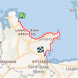
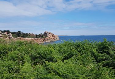
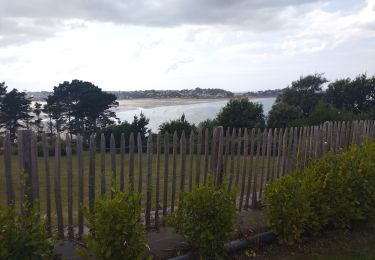
Ruta Senderismo de 8,1 km a descubrir en Bretaña, Côtes-d'Armor, Perros-Guirec. Esta ruta ha sido propuesta por tracegps.
Descripción
Très jolie promenade sur le Sentier des Douaniers. Vue sur la mer et découverte sur le chemin d'une superbe plage avec ses commerces (Trestaou).
Localización
País:
France
Región :
Bretaña
Departamento/provincia :
Côtes-d'Armor
Municipio :
Perros-Guirec
Localidad:
Unknown
Salida:(Dec)
Salida:(UTM)
465199 ; 5408376 (30U) N.
Comentarios
Excursiones cerca
![Excursión Senderismo Perros-Guirec - Perros-Guirec - GR34 - 11.1km 185m 2h50 - 2023 09 08 - Photo](https://media.geolcdn.com/t/375/260/d1728063-b6c3-4241-bba7-0eab61cebb20.jpg&format=jpg&maxdim=2)
![Senderismo Senderismo](https://static1.geolcdn.com/sitytour/trail-icons/101.png)
Perros-Guirec - GR34 - 11.1km 185m 2h50 - 2023 09 08
Senderismo
Medio
(1)
Perros-Guirec,
Bretaña,
Côtes-d'Armor,
France
![](/images/other/stat-length.png)
11,1 km | 13,6 km-effort
2h 50min
![](https://static1.geolcdn.com/siteimages/upload/files/16400158638029165_repeat_loop_refresh_sync_direction_icon.png)
Sí
![Excursión Senderismo Trégastel - Trégastel - GR34 Île Renote Moulin à marée Chapelle de Gorgon - 13.8km 100m 3h35 - 2023 09 07 - Photo](https://media.geolcdn.com/t/375/260/f7b585bc-cd92-4f03-b6f8-635e10f5e6be.jpg&format=jpg&maxdim=2)
![Senderismo Senderismo](https://static1.geolcdn.com/sitytour/trail-icons/101.png)
Trégastel - GR34 Île Renote Moulin à marée Chapelle de Gorgon - 13.8km 100m 3...
Senderismo
Difícil
(2)
Trégastel,
Bretaña,
Côtes-d'Armor,
France
![](/images/other/stat-length.png)
13,8 km | 15,1 km-effort
3h 35min
![](https://static1.geolcdn.com/siteimages/upload/files/16400158638029165_repeat_loop_refresh_sync_direction_icon.png)
Sí
![Excursión Senderismo Perros-Guirec - la côte de granit rose à Ploumanach - Photo](https://media.geolcdn.com/t/375/260/64deb34e-d59c-4f9a-95ec-bcb98ff541ad.jpg&format=jpg&maxdim=2)
![Senderismo Senderismo](https://static1.geolcdn.com/sitytour/trail-icons/101.png)
la côte de granit rose à Ploumanach
Senderismo
Muy fácil
(2)
Perros-Guirec,
Bretaña,
Côtes-d'Armor,
France
![](/images/other/stat-length.png)
6 km | 6,9 km-effort
2h 38min
![](https://static1.geolcdn.com/siteimages/upload/files/16400158638029165_repeat_loop_refresh_sync_direction_icon.png)
Sí
![Excursión Senderismo Perros-Guirec - Les sentiers de Ploumanac'h - Photo](https://media.geolcdn.com/t/375/260/ext.jpg?maxdim=2&url=https%3A%2F%2Fservices.sitytrail.com%2FGeolivesWS%2FDownloadMedia.ashx%3FTrailID%3D317019%26Media%3D16161_1.jpg)
![Senderismo Senderismo](https://static1.geolcdn.com/sitytour/trail-icons/101.png)
Les sentiers de Ploumanac'h
Senderismo
Medio
(2)
Perros-Guirec,
Bretaña,
Côtes-d'Armor,
France
![](/images/other/stat-length.png)
10,3 km | 12 km-effort
3h 0min
![](https://static1.geolcdn.com/siteimages/upload/files/16400158638029165_repeat_loop_refresh_sync_direction_icon.png)
Sí
![Excursión Senderismo Louannec - Louannec - GR34 PR - 11.5km 185m 3h00 (40mn) - 2023 09 14 - Photo](https://media.geolcdn.com/t/375/260/e980ede6-67ca-4aa3-94c9-619423761500.jpg&format=jpg&maxdim=2)
![Senderismo Senderismo](https://static1.geolcdn.com/sitytour/trail-icons/101.png)
Louannec - GR34 PR - 11.5km 185m 3h00 (40mn) - 2023 09 14
Senderismo
Difícil
Louannec,
Bretaña,
Côtes-d'Armor,
France
![](/images/other/stat-length.png)
11,5 km | 13,9 km-effort
3h 0min
![](https://static1.geolcdn.com/siteimages/upload/files/16400158638029165_repeat_loop_refresh_sync_direction_icon.png)
Sí
![Excursión Senderismo Trégastel - Trégastel - GR34 Ploumanac'h Kasino de Perros-Guirec - 11.7km 200m 2h55 (50mn) - 2023 09 08 - Photo](https://media.geolcdn.com/t/375/260/3132b43e-4920-4682-bf35-15b1d429cbae.jpg&format=jpg&maxdim=2)
![Senderismo Senderismo](https://static1.geolcdn.com/sitytour/trail-icons/101.png)
Trégastel - GR34 Ploumanac'h Kasino de Perros-Guirec - 11.7km 200m 2h55 (50mn...
Senderismo
Medio
Trégastel,
Bretaña,
Côtes-d'Armor,
France
![](/images/other/stat-length.png)
11,7 km | 14,4 km-effort
2h 55min
![](https://static1.geolcdn.com/siteimages/upload/files/16400158638029165_repeat_loop_refresh_sync_direction_icon.png)
Sí
![Excursión Senderismo Pleumeur-Bodou - Pleumeur-Bodou - GR34 Chapelle Saint-Samson - 7.7km 60m 1h55 - 2023 09 06 - Photo](https://media.geolcdn.com/t/375/260/5d74374c-67e8-400e-845c-98d92708147a.jpg&format=jpg&maxdim=2)
![Senderismo Senderismo](https://static1.geolcdn.com/sitytour/trail-icons/101.png)
Pleumeur-Bodou - GR34 Chapelle Saint-Samson - 7.7km 60m 1h55 - 2023 09 06
Senderismo
Medio
Pleumeur-Bodou,
Bretaña,
Côtes-d'Armor,
France
![](/images/other/stat-length.png)
7,7 km | 8,5 km-effort
1h 55min
![](https://static1.geolcdn.com/siteimages/upload/files/16400158638029165_repeat_loop_refresh_sync_direction_icon.png)
Sí
![Excursión Cicloturismo Pleumeur-Bodou - Landrellec à kercoz - Photo](https://media.geolcdn.com/t/375/260/9edc18fe-d348-4dcd-a457-97cbb66b8768.jpg&format=jpg&maxdim=2)
![Cicloturismo Cicloturismo](https://static1.geolcdn.com/sitytour/trail-icons/204.png)
Landrellec à kercoz
Cicloturismo
Fácil
Pleumeur-Bodou,
Bretaña,
Côtes-d'Armor,
France
![](/images/other/stat-length.png)
52 km | 61 km-effort
4h 19min
![](https://static1.geolcdn.com/siteimages/upload/files/16400158638029165_repeat_loop_refresh_sync_direction_icon.png)
No
![Excursión Senderismo Trégastel - GR34-EtapeIII-J05 - Photo](https://media.geolcdn.com/t/375/260/ext.jpg?maxdim=2&url=https%3A%2F%2Fstatic1.geolcdn.com%2Fsiteimages%2Fupload%2Ffiles%2F1553511878bg_sport_marche.png)
![Senderismo Senderismo](https://static1.geolcdn.com/sitytour/trail-icons/101.png)
GR34-EtapeIII-J05
Senderismo
Fácil
(1)
Trégastel,
Bretaña,
Côtes-d'Armor,
France
![](/images/other/stat-length.png)
19,2 km | 21 km-effort
6h 30min
![](https://static1.geolcdn.com/siteimages/upload/files/16400158638029165_repeat_loop_refresh_sync_direction_icon.png)
No