![](/images/other/stat-length.png)
![Excursión Senderismo Sainte-Agnès - Le Grand Replomb 2506m, traversée depuis Pré Marcel - Photo](https://media.geolcdn.com/t/1900/400/ext.pjpeg?maxdim=2&url=https%3A%2F%2Fservices.sitytrail.com%2FGeolivesWS%2FDownloadMedia.ashx%3FTrailID%3D316992%26Media%3D16123_1.jpg)
Le Grand Replomb 2506m, traversée depuis Pré Marcel
tracegps
Usuario
![Longitud](/images/other/stat-length.png)
![Altitud máxima](https://static1.geolcdn.com/siteimages/upload/files/1508320355ic_sort_altitude_max_24dp.png)
![Desnivel positivo](https://static1.geolcdn.com/siteimages/upload/files/1508320355ic_sort_den_pos_24dp.png)
![Km-Effort](/images/other/stat-length.png)
![Altitud mínima](https://static1.geolcdn.com/siteimages/upload/files/1508320355ic_sort_altitude_min_24dp.png)
![Desnivel negativo](https://static1.geolcdn.com/siteimages/upload/files/1508320355ic_sort_den_neg_24dp.png)
![Boucle](https://static1.geolcdn.com/siteimages/upload/files/16400158638029165_repeat_loop_refresh_sync_direction_icon.png)
![Senderismo](https://static1.geolcdn.com/sitytour/trail-icons/101.png)
7h15
Dificultad : Difícil
![Escanee este código QR para abrir la excursión en la aplicación SityTrail](https://capi.geolives.com/qq0zvz2zws4bq2lad0pu/sitytour/trails/316992/qr.png?size=200)
Aplicación GPS de excursión GRATIS
A propósito
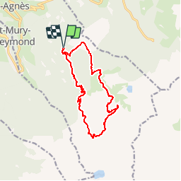
Ruta Senderismo de 13,5 km a descubrir en Auvergne-Rhône-Alpes, Isère, Sainte-Agnès. Esta ruta ha sido propuesta por tracegps.
Descripción
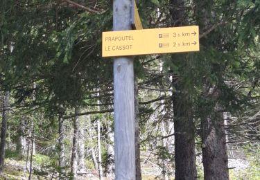
Dans l'ambiance sauvage de Belledonne, le Grand Replomb offre le panorama saisissant de la cuvette de Grenoble et du Grésivaudan. Partant du Pré Marcel, la randonnée monte par le refuge Jean Collet trouver le pied d'un raide couloir orienté Nord Est sous la crête de Jas Mouton qui donne accès à un vallon pierreux pour déboucher près du sommet. Plus aventureuse la descente commence par l'arête Sud Ouest pour rejoindre un large replat accueillant. Une traversée amène dans la combe Nord Ouest issu du Grand Replomb qu'un pierrier dévale pour trouver le sentier du Col du Rafour. De bonnes traces descendent au Habert de Jarlons. Le chemin de crête de la Montagne de Barlet permettra de rejoindre le point de départ. Description complète sur sentier-nature.com : Le Grand Replomb 2506 m, traversée depuis Pré Marcel Avertissement [Exposition 1/3 ; Orientation 2/3 ; Pénibilité 2/3]. Certains passages de cet itinéraire de montagne sont escarpés et/ou exposés, il est déconseillé aux enfants non accompagnés et aux personnes sujettes au vertige. Pour votre sécurité, nous vous invitons à respecter les règles suivantes : être bien chaussé, ne pas s'engager par mauvais temps, ne pas s'écarter de l'itinéraire ni des sentiers.
Localización
Comentarios
Excursiones cerca
![Excursión Senderismo Les Adrets - les 7 laux - Photo](https://media.geolcdn.com/t/375/260/ext.jpg?maxdim=2&url=https%3A%2F%2Fservices.sitytrail.com%2FGeolivesWS%2FDownloadMedia.ashx%3FTrailID%3D210621%26Media%3Dfix__20130806134428.jpg)
![Senderismo Senderismo](https://static1.geolcdn.com/sitytour/trail-icons/101.png)
Senderismo
![](/images/other/stat-length.png)
![](https://static1.geolcdn.com/siteimages/upload/files/16400158638029165_repeat_loop_refresh_sync_direction_icon.png)
![Excursión A pie La Combe-de-Lancey - Chemin de Découverte (boucle Basse) - Photo](https://media.geolcdn.com/t/375/260/6915f95f-b034-4e84-88aa-9ed85af7f443.jpeg&format=jpg&maxdim=2)
![A pie A pie](https://static1.geolcdn.com/sitytour/trail-icons/100.png)
A pie
![](/images/other/stat-length.png)
![](https://static1.geolcdn.com/siteimages/upload/files/16400158638029165_repeat_loop_refresh_sync_direction_icon.png)
![Excursión A pie La Combe-de-Lancey - Chemin de Découverte (boucle Haute) - Photo](https://media.geolcdn.com/t/375/260/6a0cb0d1-93da-4068-99ad-9a549161cacf.jpeg&format=jpg&maxdim=2)
![A pie A pie](https://static1.geolcdn.com/sitytour/trail-icons/100.png)
A pie
![](/images/other/stat-length.png)
![](https://static1.geolcdn.com/siteimages/upload/files/16400158638029165_repeat_loop_refresh_sync_direction_icon.png)
![Excursión Esquí de fondo Les Adrets - le jas de lièvre et vol de Bédina - Photo](https://media.geolcdn.com/t/375/260/fb6d4008-e294-44a8-86f0-b378b0a893a8.jpg&format=jpg&maxdim=2)
![Esquí de fondo Esquí de fondo](https://static1.geolcdn.com/sitytour/trail-icons/503.png)
Esquí de fondo
![](/images/other/stat-length.png)
![](https://static1.geolcdn.com/siteimages/upload/files/16400158638029165_repeat_loop_refresh_sync_direction_icon.png)
![Excursión Esquí de fondo Laval-en-Belledonne - col du Rafour et couloir ouest de la montagne de Barlet - Photo](https://media.geolcdn.com/t/375/260/93573ad3-540b-4442-acb2-432d15b1a0ec.jpg&format=jpg&maxdim=2)
![Esquí de fondo Esquí de fondo](https://static1.geolcdn.com/sitytour/trail-icons/503.png)
Esquí de fondo
![](/images/other/stat-length.png)
![](https://static1.geolcdn.com/siteimages/upload/files/16400158638029165_repeat_loop_refresh_sync_direction_icon.png)
![Excursión Esquí de fondo Laval-en-Belledonne - la dent du Pra par le col de l'Aigleton - Photo](https://media.geolcdn.com/t/375/260/35f172bb-b4cf-4c46-abfa-0c6386b3c585.jpg&format=jpg&maxdim=2)
![Esquí de fondo Esquí de fondo](https://static1.geolcdn.com/sitytour/trail-icons/503.png)
Esquí de fondo
![](/images/other/stat-length.png)
![](https://static1.geolcdn.com/siteimages/upload/files/16400158638029165_repeat_loop_refresh_sync_direction_icon.png)
![Excursión Esquí de fondo Laval-en-Belledonne - couloir Est du sifflet et pas du pin par couloir ouest - Photo](https://media.geolcdn.com/t/375/260/923162f4-fc60-40a4-900d-69278daa194d.jpg&format=jpg&maxdim=2)
![Esquí de fondo Esquí de fondo](https://static1.geolcdn.com/sitytour/trail-icons/503.png)
Esquí de fondo
![](/images/other/stat-length.png)
![](https://static1.geolcdn.com/siteimages/upload/files/16400158638029165_repeat_loop_refresh_sync_direction_icon.png)
![Excursión Senderismo Theys - BALADE DIGESTIVE APRES UNE FONDUE - Photo](https://media.geolcdn.com/t/375/260/be78689d-589e-4895-90df-62de51c805ee.jpg&format=jpg&maxdim=2)
![Senderismo Senderismo](https://static1.geolcdn.com/sitytour/trail-icons/101.png)
Senderismo
![](/images/other/stat-length.png)
![](https://static1.geolcdn.com/siteimages/upload/files/16400158638029165_repeat_loop_refresh_sync_direction_icon.png)
![Excursión Senderismo Laval-en-Belledonne - PETITE RANDONNEE AU DEPART DU PONT DE LA BETTA - Photo](https://media.geolcdn.com/t/375/260/75136744-9eff-4307-a3ab-8becdc263614.jpg&format=jpg&maxdim=2)
![Senderismo Senderismo](https://static1.geolcdn.com/sitytour/trail-icons/101.png)
Senderismo
![](/images/other/stat-length.png)
![](https://static1.geolcdn.com/siteimages/upload/files/16400158638029165_repeat_loop_refresh_sync_direction_icon.png)