![](/images/other/stat-length.png)
![Excursión Senderismo Rochefort-Samson - Rochefort Sanson - Photo](https://media.geolcdn.com/t/1900/400/ext.pjpeg?maxdim=2&url=https%3A%2F%2Fstatic1.geolcdn.com%2Fsiteimages%2Fupload%2Ffiles%2F1553511878bg_sport_marche.png)
Rochefort Sanson
meillon
Usuario
![Longitud](/images/other/stat-length.png)
Longitud
7,5 km
![Altitud máxima](https://static1.geolcdn.com/siteimages/upload/files/1508320355ic_sort_altitude_max_24dp.png)
Altitud máxima
615 m
![Desnivel positivo](https://static1.geolcdn.com/siteimages/upload/files/1508320355ic_sort_den_pos_24dp.png)
Desnivel positivo
270 m
![Km-Effort](/images/other/stat-length.png)
Km-Effort
11,1 km
![Altitud mínima](https://static1.geolcdn.com/siteimages/upload/files/1508320355ic_sort_altitude_min_24dp.png)
Altitud mínima
375 m
![Desnivel negativo](https://static1.geolcdn.com/siteimages/upload/files/1508320355ic_sort_den_neg_24dp.png)
Desnivel negativo
268 m
![Boucle](https://static1.geolcdn.com/siteimages/upload/files/16400158638029165_repeat_loop_refresh_sync_direction_icon.png)
Boucle
Sí
Fecha de creación :
2022-03-15 08:59:06.217
Última modificación :
2022-03-15 12:16:25.887
![Senderismo](https://static1.geolcdn.com/sitytour/trail-icons/101.png)
2h48
Dificultad : Medio
![Escanee este código QR para abrir la excursión en la aplicación SityTrail](https://capi.geolives.com/qq0zvz2zws4bq2lad0pu/sitytour/trails/3167674/qr.png?size=200)
Aplicación GPS de excursión GRATIS
A propósito
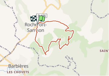
Ruta Senderismo de 7,5 km a descubrir en Auvergne-Rhône-Alpes, Drôme, Rochefort-Samson. Esta ruta ha sido propuesta por meillon.
Descripción
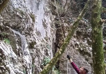
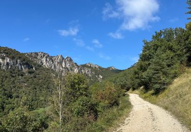
Du village on dépasse en montant une chapelle puis les restes d une carrière étonnante avec un étang vert, on ne pénètre pas. Ensuite en montant vers les ruines d un vieux château on découvre la vaste plaine de Romans Valence.
Localización
País:
France
Región :
Auvergne-Rhône-Alpes
Departamento/provincia :
Drôme
Municipio :
Rochefort-Samson
Localidad:
Unknown
Salida:(Dec)
Salida:(UTM)
669637 ; 4982149 (31T) N.
Comentarios
Excursiones cerca
![Excursión Senderismo Beauregard-Baret - Pré de Cinq Sous - Beauregard Baret - Photo](https://media.geolcdn.com/t/375/260/ext.jpg?maxdim=2&url=https%3A%2F%2Fservices.sitytrail.com%2FGeolivesWS%2FDownloadMedia.ashx%3FTrailID%3D214828%26Media%3D15342_3.jpg)
![Senderismo Senderismo](https://static1.geolcdn.com/sitytour/trail-icons/101.png)
Pré de Cinq Sous - Beauregard Baret
Senderismo
Medio
(1)
Beauregard-Baret,
Auvergne-Rhône-Alpes,
Drôme,
France
![](/images/other/stat-length.png)
11,6 km | 23 km-effort
5h 0min
![](https://static1.geolcdn.com/siteimages/upload/files/16400158638029165_repeat_loop_refresh_sync_direction_icon.png)
Sí
![Excursión Senderismo Rochefort-Samson - Les Vachères - Combe d'oyans - Photo](https://media.geolcdn.com/t/375/260/b496d0d5-f9c5-4087-8105-422c092be197.jpg&format=jpg&maxdim=2)
![Senderismo Senderismo](https://static1.geolcdn.com/sitytour/trail-icons/101.png)
Les Vachères - Combe d'oyans
Senderismo
Difícil
(1)
Rochefort-Samson,
Auvergne-Rhône-Alpes,
Drôme,
France
![](/images/other/stat-length.png)
17,1 km | 28 km-effort
8h 26min
![](https://static1.geolcdn.com/siteimages/upload/files/16400158638029165_repeat_loop_refresh_sync_direction_icon.png)
Sí
![Excursión Senderismo Beauregard-Baret - reco cx st Gervais b baret - Photo](https://media.geolcdn.com/t/375/260/62f4b6af-f36d-4d7e-9bf7-cff82879ff65.jpg&format=jpg&maxdim=2)
![Senderismo Senderismo](https://static1.geolcdn.com/sitytour/trail-icons/101.png)
reco cx st Gervais b baret
Senderismo
Difícil
Beauregard-Baret,
Auvergne-Rhône-Alpes,
Drôme,
France
![](/images/other/stat-length.png)
9,4 km | 16,2 km-effort
4h 58min
![](https://static1.geolcdn.com/siteimages/upload/files/16400158638029165_repeat_loop_refresh_sync_direction_icon.png)
No
![Excursión Senderismo Saint-Vincent-la-Commanderie - 26 st Vincent commanderie zel - Photo](https://media.geolcdn.com/t/375/260/64d0078a-2be9-41db-957b-395e9e3d9a48.jpg&format=jpg&maxdim=2)
![Senderismo Senderismo](https://static1.geolcdn.com/sitytour/trail-icons/101.png)
26 st Vincent commanderie zel
Senderismo
Fácil
Saint-Vincent-la-Commanderie,
Auvergne-Rhône-Alpes,
Drôme,
France
![](/images/other/stat-length.png)
14,2 km | 22 km-effort
6h 5min
![](https://static1.geolcdn.com/siteimages/upload/files/16400158638029165_repeat_loop_refresh_sync_direction_icon.png)
Sí
![Excursión Senderismo Beauregard-Baret - croix st Gervais et Pas du loup - Photo](https://media.geolcdn.com/t/375/260/31db5131-e481-415d-9c06-0a841965de22.jpg&format=jpg&maxdim=2)
![Senderismo Senderismo](https://static1.geolcdn.com/sitytour/trail-icons/101.png)
croix st Gervais et Pas du loup
Senderismo
Medio
Beauregard-Baret,
Auvergne-Rhône-Alpes,
Drôme,
France
![](/images/other/stat-length.png)
10 km | 16,9 km-effort
5h 4min
![](https://static1.geolcdn.com/siteimages/upload/files/16400158638029165_repeat_loop_refresh_sync_direction_icon.png)
No
![Excursión Senderismo Chatuzange-le-Goubet - autour de Papelissier - Photo](https://media.geolcdn.com/t/375/260/ext.jpg?maxdim=2&url=https%3A%2F%2Fstatic1.geolcdn.com%2Fsiteimages%2Fupload%2Ffiles%2F1553511878bg_sport_marche.png)
![Senderismo Senderismo](https://static1.geolcdn.com/sitytour/trail-icons/101.png)
autour de Papelissier
Senderismo
Muy fácil
(1)
Chatuzange-le-Goubet,
Auvergne-Rhône-Alpes,
Drôme,
France
![](/images/other/stat-length.png)
16,5 km | 21 km-effort
3h 20min
![](https://static1.geolcdn.com/siteimages/upload/files/16400158638029165_repeat_loop_refresh_sync_direction_icon.png)
Sí
![Excursión Senderismo Barbières - 26 pierre chauve barbieres zel - Photo](https://media.geolcdn.com/t/375/260/92caf138-cce3-4645-835e-f3491e5ff577.jpg&format=jpg&maxdim=2)
![Senderismo Senderismo](https://static1.geolcdn.com/sitytour/trail-icons/101.png)
26 pierre chauve barbieres zel
Senderismo
Medio
Barbières,
Auvergne-Rhône-Alpes,
Drôme,
France
![](/images/other/stat-length.png)
13,8 km | 26 km-effort
7h 9min
![](https://static1.geolcdn.com/siteimages/upload/files/16400158638029165_repeat_loop_refresh_sync_direction_icon.png)
No
![Excursión sport Beauregard-Baret - Pierre rousse pas de pourceau l’eau basse - Photo](https://media.geolcdn.com/t/375/260/8f7985a7-111f-4318-9d67-55ef317841a8.jpg&format=jpg&maxdim=2)
Pierre rousse pas de pourceau l’eau basse
sport
Muy fácil
Beauregard-Baret,
Auvergne-Rhône-Alpes,
Drôme,
France
![](/images/other/stat-length.png)
14,7 km | 28 km-effort
Desconocido
![](https://static1.geolcdn.com/siteimages/upload/files/16400158638029165_repeat_loop_refresh_sync_direction_icon.png)
Sí
![Excursión Senderismo Barbières - Traversée Barbières Beauregard-Baret - Photo](https://media.geolcdn.com/t/375/260/2a3121e4-a036-4b19-8247-21a832e98ad8.jpg&format=jpg&maxdim=2)
![Senderismo Senderismo](https://static1.geolcdn.com/sitytour/trail-icons/101.png)
Traversée Barbières Beauregard-Baret
Senderismo
Muy difícil
Barbières,
Auvergne-Rhône-Alpes,
Drôme,
France
![](/images/other/stat-length.png)
17 km | 28 km-effort
7h 9min
![](https://static1.geolcdn.com/siteimages/upload/files/16400158638029165_repeat_loop_refresh_sync_direction_icon.png)
No