![](/images/other/stat-length.png)
![Excursión Senderismo Châteauneuf-sur-Cher - Le Cher majestueux à Châteauneuf sur Cher - Photo](https://media.geolcdn.com/t/1900/400/ext.pjpeg?maxdim=2&url=https%3A%2F%2Fservices.sitytrail.com%2FGeolivesWS%2FDownloadMedia.ashx%3FTrailID%3D316753%26Media%3D4667_1.jpg)
Le Cher majestueux à Châteauneuf sur Cher
tracegps
Usuario
![Longitud](/images/other/stat-length.png)
Longitud
23 km
![Altitud máxima](https://static1.geolcdn.com/siteimages/upload/files/1508320355ic_sort_altitude_max_24dp.png)
Altitud máxima
181 m
![Desnivel positivo](https://static1.geolcdn.com/siteimages/upload/files/1508320355ic_sort_den_pos_24dp.png)
Desnivel positivo
200 m
![Km-Effort](/images/other/stat-length.png)
Km-Effort
25 km
![Altitud mínima](https://static1.geolcdn.com/siteimages/upload/files/1508320355ic_sort_altitude_min_24dp.png)
Altitud mínima
133 m
![Desnivel negativo](https://static1.geolcdn.com/siteimages/upload/files/1508320355ic_sort_den_neg_24dp.png)
Desnivel negativo
200 m
![Boucle](https://static1.geolcdn.com/siteimages/upload/files/16400158638029165_repeat_loop_refresh_sync_direction_icon.png)
Boucle
Sí
Fecha de creación :
2014-12-10 00:00:00.0
Última modificación :
2014-12-10 00:00:00.0
![Senderismo](https://static1.geolcdn.com/sitytour/trail-icons/101.png)
5h30
Dificultad : Difícil
![Escanee este código QR para abrir la excursión en la aplicación SityTrail](https://capi.geolives.com/qq0zvz2zws4bq2lad0pu/sitytour/trails/316753/qr.png?size=200)
Aplicación GPS de excursión GRATIS
A propósito
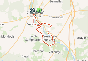
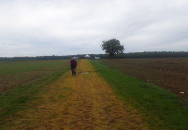
Ruta Senderismo de 23 km a descubrir en Centro, Cher, Châteauneuf-sur-Cher. Esta ruta ha sido propuesta por tracegps.
Descripción
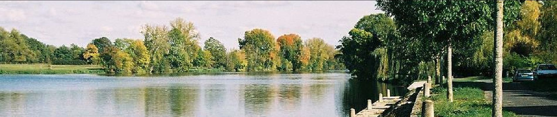
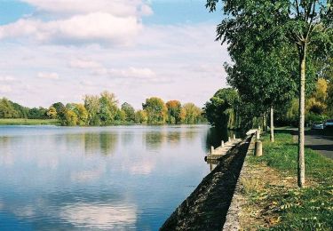
A Châteauneuf sur Cher, vous vous approcherez d'une rivière qui a su garder un caractère authentiquement sauvage. Peu de rives sont accessibles mais une quantité de points de vue surprenants et peu connus sont à découvrir.
Localización
País:
France
Región :
Centro
Departamento/provincia :
Cher
Municipio :
Châteauneuf-sur-Cher
Localidad:
Unknown
Salida:(Dec)
Salida:(UTM)
448048 ; 5189299 (31T) N.
Comentarios
Excursiones cerca
![Excursión Caballo Châteauneuf-sur-Cher - Le Cher majestueux à Châteauneuf sur Cher - Photo](https://media.geolcdn.com/t/375/260/ext.jpg?maxdim=2&url=https%3A%2F%2Fservices.sitytrail.com%2FGeolivesWS%2FDownloadMedia.ashx%3FTrailID%3D316755%26Media%3D4667_1.jpg)
![Caballo Caballo](https://static1.geolcdn.com/sitytour/trail-icons/300.png)
Le Cher majestueux à Châteauneuf sur Cher
Caballo
Difícil
(1)
Châteauneuf-sur-Cher,
Centro,
Cher,
France
![](/images/other/stat-length.png)
23 km | 25 km-effort
4h 0min
![](https://static1.geolcdn.com/siteimages/upload/files/16400158638029165_repeat_loop_refresh_sync_direction_icon.png)
Sí
![Excursión Bici de montaña Châteauneuf-sur-Cher - Le Cher majestueux à Châteauneuf sur Cher - Photo](https://media.geolcdn.com/t/375/260/ext.jpg?maxdim=2&url=https%3A%2F%2Fservices.sitytrail.com%2FGeolivesWS%2FDownloadMedia.ashx%3FTrailID%3D316754%26Media%3D4667_1.jpg)
![Bici de montaña Bici de montaña](https://static1.geolcdn.com/sitytour/trail-icons/202.png)
Le Cher majestueux à Châteauneuf sur Cher
Bici de montaña
Difícil
Châteauneuf-sur-Cher,
Centro,
Cher,
France
![](/images/other/stat-length.png)
23 km | 25 km-effort
2h 30min
![](https://static1.geolcdn.com/siteimages/upload/files/16400158638029165_repeat_loop_refresh_sync_direction_icon.png)
Sí
![Excursión Ruta Châteauneuf-sur-Cher - Châteauneuf sur cher - Photo](https://media.geolcdn.com/t/375/260/52489464-7f62-44cd-8a3a-809a7c31d2e6.jpg&format=jpg&maxdim=2)
![Ruta Ruta](https://static1.geolcdn.com/sitytour/trail-icons/104.png)
Châteauneuf sur cher
Ruta
Muy fácil
Châteauneuf-sur-Cher,
Centro,
Cher,
France
![](/images/other/stat-length.png)
17,7 km | 20 km-effort
2h 17min
![](https://static1.geolcdn.com/siteimages/upload/files/16400158638029165_repeat_loop_refresh_sync_direction_icon.png)
Sí
![Excursión Otra actividad Châteauneuf-sur-Cher - château jeux 30 - Photo](https://media.geolcdn.com/t/375/260/ext.jpg?maxdim=2&url=https%3A%2F%2Fstatic1.geolcdn.com%2Fsiteimages%2Fupload%2Ffiles%2F1545311037marcheuse_200dpi.jpg)
![Otra actividad Otra actividad](https://static1.geolcdn.com/sitytour/trail-icons/900.png)
château jeux 30
Otra actividad
Muy fácil
Châteauneuf-sur-Cher,
Centro,
Cher,
France
![](/images/other/stat-length.png)
28 km | 31 km-effort
1h 40min
![](https://static1.geolcdn.com/siteimages/upload/files/16400158638029165_repeat_loop_refresh_sync_direction_icon.png)
Sí
![Excursión Senderismo Venesmes - VENESMES 15km - Photo](https://media.geolcdn.com/t/375/260/ext.jpg?maxdim=2&url=https%3A%2F%2Fstatic1.geolcdn.com%2Fsiteimages%2Fupload%2Ffiles%2F1553511878bg_sport_marche.png)
![Senderismo Senderismo](https://static1.geolcdn.com/sitytour/trail-icons/101.png)
VENESMES 15km
Senderismo
Difícil
Venesmes,
Centro,
Cher,
France
![](/images/other/stat-length.png)
14,6 km | 16,3 km-effort
3h 42min
![](https://static1.geolcdn.com/siteimages/upload/files/16400158638029165_repeat_loop_refresh_sync_direction_icon.png)
Sí
![Excursión Senderismo Serruelles - SERRUELLES 6km - Photo](https://media.geolcdn.com/t/375/260/ext.jpg?maxdim=2&url=https%3A%2F%2Fstatic1.geolcdn.com%2Fsiteimages%2Fupload%2Ffiles%2F1553511878bg_sport_marche.png)
![Senderismo Senderismo](https://static1.geolcdn.com/sitytour/trail-icons/101.png)
![Excursión Senderismo Saint-Symphorien - SAINT SYMPHORIEN 12km - Photo](https://media.geolcdn.com/t/375/260/ext.jpg?maxdim=2&url=https%3A%2F%2Fstatic1.geolcdn.com%2Fsiteimages%2Fupload%2Ffiles%2F1553511878bg_sport_marche.png)
![Senderismo Senderismo](https://static1.geolcdn.com/sitytour/trail-icons/101.png)
SAINT SYMPHORIEN 12km
Senderismo
Difícil
Saint-Symphorien,
Centro,
Cher,
France
![](/images/other/stat-length.png)
12,5 km | 13,9 km-effort
3h 8min
![](https://static1.geolcdn.com/siteimages/upload/files/16400158638029165_repeat_loop_refresh_sync_direction_icon.png)
Sí
![Excursión Senderismo Crézançay-sur-Cher - CREZANCAY 10km - Photo](https://media.geolcdn.com/t/375/260/ext.jpg?maxdim=2&url=https%3A%2F%2Fstatic1.geolcdn.com%2Fsiteimages%2Fupload%2Ffiles%2F1553511878bg_sport_marche.png)
![Senderismo Senderismo](https://static1.geolcdn.com/sitytour/trail-icons/101.png)
CREZANCAY 10km
Senderismo
Medio
Crézançay-sur-Cher,
Centro,
Cher,
France
![](/images/other/stat-length.png)
10,1 km | 11,4 km-effort
2h 35min
![](https://static1.geolcdn.com/siteimages/upload/files/16400158638029165_repeat_loop_refresh_sync_direction_icon.png)
Sí