![](/images/other/stat-length.png)
![Excursión Senderismo Binic-Étables-sur-Mer - GR 34® d'Etables sur Mer à Lanloup - Photo](https://media.geolcdn.com/t/1900/400/ext.pjpeg?maxdim=2&url=https%3A%2F%2Fservices.sitytrail.com%2FGeolivesWS%2FDownloadMedia.ashx%3FTrailID%3D316666%26Media%3D3793_1.jpg)
GR 34® d'Etables sur Mer à Lanloup
tracegps
Usuario
![Longitud](/images/other/stat-length.png)
![Altitud máxima](https://static1.geolcdn.com/siteimages/upload/files/1508320355ic_sort_altitude_max_24dp.png)
![Desnivel positivo](https://static1.geolcdn.com/siteimages/upload/files/1508320355ic_sort_den_pos_24dp.png)
![Km-Effort](/images/other/stat-length.png)
![Altitud mínima](https://static1.geolcdn.com/siteimages/upload/files/1508320355ic_sort_altitude_min_24dp.png)
![Desnivel negativo](https://static1.geolcdn.com/siteimages/upload/files/1508320355ic_sort_den_neg_24dp.png)
![Boucle](https://static1.geolcdn.com/siteimages/upload/files/16400158638029165_repeat_loop_refresh_sync_direction_icon.png)
![Senderismo](https://static1.geolcdn.com/sitytour/trail-icons/101.png)
6h00
Dificultad : Difícil
![Escanee este código QR para abrir la excursión en la aplicación SityTrail](https://capi.geolives.com/qq0zvz2zws4bq2lad0pu/sitytour/trails/316666/qr.png?size=200)
Aplicación GPS de excursión GRATIS
A propósito
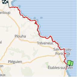
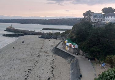
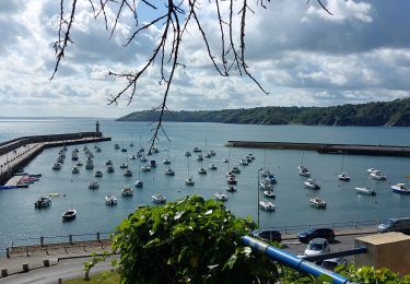
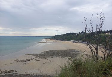
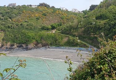
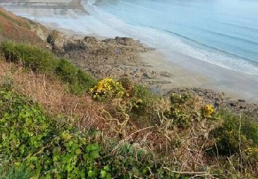
Ruta Senderismo de 23 km a descubrir en Bretaña, Côtes-d'Armor, Binic-Étables-sur-Mer. Esta ruta ha sido propuesta por tracegps.
Descripción
GR34® Côte de Granit Rose GR 34® d'Etables sur Mer à Lanloup Vous trouverez le descriptif détaillé de cette randonnée dans le Topo-guide® de la Fédération Française de la Randonnée Pédestre. Le découpage proposé ici est donné à titre indicatif pour équilibrer la distance de chaque tronçon. Chacun peut l’adapter à son niveau.
Localización
Comentarios
Excursiones cerca
![Excursión Senderismo Binic-Étables-sur-Mer - Binic la Banche - GR34 Plage des Rosaires - 22.2km 530m 5h10 (35mn) - 2024 07 04 - Photo](https://media.geolcdn.com/t/375/260/0e0696b4-8bd5-4cba-af7b-1ae7885cab34.jpg&format=jpg&maxdim=2)
![Senderismo Senderismo](https://static1.geolcdn.com/sitytour/trail-icons/101.png)
Senderismo
![](/images/other/stat-length.png)
![](https://static1.geolcdn.com/siteimages/upload/files/16400158638029165_repeat_loop_refresh_sync_direction_icon.png)
![Excursión Senderismo Tréveneuc - Tréveneuc Chapelle Saint-Marc - GR34 Plage de la Banche - 24.8km 420m 5h35 (40mn) - 2024 07 03 - Photo](https://media.geolcdn.com/t/375/260/51710ac1-2892-4699-8de2-befb83d8a9f9.jpg&format=jpg&maxdim=2)
![Senderismo Senderismo](https://static1.geolcdn.com/sitytour/trail-icons/101.png)
Senderismo
![](/images/other/stat-length.png)
![](https://static1.geolcdn.com/siteimages/upload/files/16400158638029165_repeat_loop_refresh_sync_direction_icon.png)
![Excursión Senderismo Binic-Étables-sur-Mer - PR_22_Binic-Etables-Sur-Mer_AA_04_Entre-Mer-Et-Villages - Photo](https://media.geolcdn.com/t/375/260/6b174437-638a-4e9f-8182-a143c29a39f6.jpg&format=jpg&maxdim=2)
![Senderismo Senderismo](https://static1.geolcdn.com/sitytour/trail-icons/101.png)
Senderismo
![](/images/other/stat-length.png)
![](https://static1.geolcdn.com/siteimages/upload/files/16400158638029165_repeat_loop_refresh_sync_direction_icon.png)
![Excursión Senderismo Binic-Étables-sur-Mer - GR_34_CE_18_Binic-Etables-Sur-Mer_Treveneuc_20240526 - Photo](https://media.geolcdn.com/t/375/260/1eec5e32-a44b-4dd1-b655-7ade1a04ea02.jpg&format=jpg&maxdim=2)
![Senderismo Senderismo](https://static1.geolcdn.com/sitytour/trail-icons/101.png)
Senderismo
![](/images/other/stat-length.png)
![](https://static1.geolcdn.com/siteimages/upload/files/16400158638029165_repeat_loop_refresh_sync_direction_icon.png)
![Excursión Senderismo Saint-Quay-Portrieux - St Quay Portrieux - Étables/mer 14.7.23 - Photo](https://media.geolcdn.com/t/375/260/801e9761-4756-4efe-a57a-47da7d14ee4b.jpg&format=jpg&maxdim=2)
![Senderismo Senderismo](https://static1.geolcdn.com/sitytour/trail-icons/101.png)
Senderismo
![](/images/other/stat-length.png)
![](https://static1.geolcdn.com/siteimages/upload/files/16400158638029165_repeat_loop_refresh_sync_direction_icon.png)
![Excursión Senderismo Saint-Quay-Portrieux - Littoral St Quay - Portrieux 11.7.23 - Photo](https://media.geolcdn.com/t/375/260/b008bde8-45e1-433c-96f8-098331e0d2cb.jpg&format=jpg&maxdim=2)
![Senderismo Senderismo](https://static1.geolcdn.com/sitytour/trail-icons/101.png)
Senderismo
![](/images/other/stat-length.png)
![](https://static1.geolcdn.com/siteimages/upload/files/16400158638029165_repeat_loop_refresh_sync_direction_icon.png)
![Excursión Senderismo Pordic - le tour du cpucou - Photo](https://media.geolcdn.com/t/375/260/ae78ff4e-96d8-40a8-8a36-66f27e4d1dc2.jpg&format=jpg&maxdim=2)
![Senderismo Senderismo](https://static1.geolcdn.com/sitytour/trail-icons/101.png)
Senderismo
![](/images/other/stat-length.png)
![](https://static1.geolcdn.com/siteimages/upload/files/16400158638029165_repeat_loop_refresh_sync_direction_icon.png)
![Excursión Senderismo Binic-Étables-sur-Mer - binic - Photo](https://media.geolcdn.com/t/375/260/b2a521c0-6bb9-4f67-9cab-44867c2a656d.jpg&format=jpg&maxdim=2)
![Senderismo Senderismo](https://static1.geolcdn.com/sitytour/trail-icons/101.png)
Senderismo
![](/images/other/stat-length.png)
![](https://static1.geolcdn.com/siteimages/upload/files/16400158638029165_repeat_loop_refresh_sync_direction_icon.png)
![Excursión Senderismo Saint-Quay-Portrieux - GR 34 étape 18 - Photo](https://media.geolcdn.com/t/375/260/ext.jpg?maxdim=2&url=https%3A%2F%2Fservices.sitytrail.com%2FGeolivesWS%2FDownloadMedia.ashx%3FTrailID%3D271059%26Media%3Dfix__20140424095302.jpg)
![Senderismo Senderismo](https://static1.geolcdn.com/sitytour/trail-icons/101.png)
Senderismo
![](/images/other/stat-length.png)
![](https://static1.geolcdn.com/siteimages/upload/files/16400158638029165_repeat_loop_refresh_sync_direction_icon.png)