![](/images/other/stat-length.png)
![Excursión Senderismo Lamastre - Lamastre - Les Nonières - Le Pouzat -Beauvert - St A grève - Photo](https://media.geolcdn.com/t/1900/400/ext.pjpeg?maxdim=2&url=https%3A%2F%2Fstatic1.geolcdn.com%2Fsiteimages%2Fupload%2Ffiles%2F1553511878bg_sport_marche.png)
Lamastre - Les Nonières - Le Pouzat -Beauvert - St A grève
pol7
Usuario
![Longitud](/images/other/stat-length.png)
Longitud
27 km
![Altitud máxima](https://static1.geolcdn.com/siteimages/upload/files/1508320355ic_sort_altitude_max_24dp.png)
Altitud máxima
1171 m
![Desnivel positivo](https://static1.geolcdn.com/siteimages/upload/files/1508320355ic_sort_den_pos_24dp.png)
Desnivel positivo
1283 m
![Km-Effort](/images/other/stat-length.png)
Km-Effort
42 km
![Altitud mínima](https://static1.geolcdn.com/siteimages/upload/files/1508320355ic_sort_altitude_min_24dp.png)
Altitud mínima
375 m
![Desnivel negativo](https://static1.geolcdn.com/siteimages/upload/files/1508320355ic_sort_den_neg_24dp.png)
Desnivel negativo
629 m
![Boucle](https://static1.geolcdn.com/siteimages/upload/files/16400158638029165_repeat_loop_refresh_sync_direction_icon.png)
Boucle
No
Fecha de creación :
2022-03-09 07:25:26.529
Última modificación :
2022-03-09 07:29:43.958
![Senderismo](https://static1.geolcdn.com/sitytour/trail-icons/101.png)
9h35
Dificultad : Muy difícil
![Escanee este código QR para abrir la excursión en la aplicación SityTrail](https://capi.geolives.com/qq0zvz2zws4bq2lad0pu/sitytour/trails/3160244/qr.png?size=200)
Aplicación GPS de excursión GRATIS
A propósito
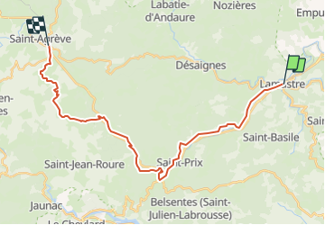
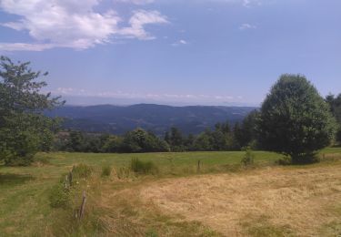
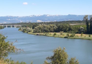
Ruta Senderismo de 27 km a descubrir en Auvergne-Rhône-Alpes, Ardecha, Lamastre. Esta ruta ha sido propuesta por pol7.
Descripción
Départ sur la Dolce Via , puis des Nonières aux Barraques belle grimpette. Bel entrainement et paysages très variés.
Localización
País:
France
Región :
Auvergne-Rhône-Alpes
Departamento/provincia :
Ardecha
Municipio :
Lamastre
Localidad:
Unknown
Salida:(Dec)
Salida:(UTM)
624643 ; 4982475 (31T) N.
Comentarios
Excursiones cerca
![Excursión sport Lamastre - Lamastre Montreynaud - Photo](https://media.geolcdn.com/t/375/260/ext.jpg?maxdim=2&url=https%3A%2F%2Fmedia.geolcdn.com%2Ff%2Fe3a95936-7852-46e6-9594-ca2320bdcff1.jpg)
Lamastre Montreynaud
sport
Muy fácil
(1)
Lamastre,
Auvergne-Rhône-Alpes,
Ardecha,
France
![](/images/other/stat-length.png)
17,7 km | 26 km-effort
Desconocido
![](https://static1.geolcdn.com/siteimages/upload/files/16400158638029165_repeat_loop_refresh_sync_direction_icon.png)
Sí
![Excursión sport Lamastre - Lamastre Desaignes - Photo](https://media.geolcdn.com/t/375/260/ext.jpg?maxdim=2&url=https%3A%2F%2Fmedia.geolcdn.com%2Ff%2F88d2b22c-07a1-4c4b-8c77-da0bd4365409.jpg)
Lamastre Desaignes
sport
Muy fácil
Lamastre,
Auvergne-Rhône-Alpes,
Ardecha,
France
![](/images/other/stat-length.png)
21 km | 29 km-effort
Desconocido
![](https://static1.geolcdn.com/siteimages/upload/files/16400158638029165_repeat_loop_refresh_sync_direction_icon.png)
Sí
![Excursión Senderismo Lamastre - urbilhac - Photo](https://media.geolcdn.com/t/375/260/ext.jpg?maxdim=2&url=https%3A%2F%2Fstatic1.geolcdn.com%2Fsiteimages%2Fupload%2Ffiles%2F1553511878bg_sport_marche.png)
![Senderismo Senderismo](https://static1.geolcdn.com/sitytour/trail-icons/101.png)
urbilhac
Senderismo
Muy fácil
(1)
Lamastre,
Auvergne-Rhône-Alpes,
Ardecha,
France
![](/images/other/stat-length.png)
6,5 km | 9,6 km-effort
1h 58min
![](https://static1.geolcdn.com/siteimages/upload/files/16400158638029165_repeat_loop_refresh_sync_direction_icon.png)
Sí
![Excursión Senderismo Nozières - Col du Buisson - Nozières - Photo](https://media.geolcdn.com/t/375/260/ext.jpg?maxdim=2&url=https%3A%2F%2Fservices.sitytrail.com%2FGeolivesWS%2FDownloadMedia.ashx%3FTrailID%3D318047%26Media%3D17517_6.jpg)
![Senderismo Senderismo](https://static1.geolcdn.com/sitytour/trail-icons/101.png)
Col du Buisson - Nozières
Senderismo
Medio
Nozières,
Auvergne-Rhône-Alpes,
Ardecha,
France
![](/images/other/stat-length.png)
12 km | 18 km-effort
3h 30min
![](https://static1.geolcdn.com/siteimages/upload/files/16400158638029165_repeat_loop_refresh_sync_direction_icon.png)
Sí
![Excursión Senderismo Lamastre - Tour de Monteil - Lamastre (07) - Photo](https://media.geolcdn.com/t/375/260/ext.jpg?maxdim=2&url=https%3A%2F%2Fservices.sitytrail.com%2FGeolivesWS%2FDownloadMedia.ashx%3FTrailID%3D104923%26Media%3D8459_6.jpg)
![Senderismo Senderismo](https://static1.geolcdn.com/sitytour/trail-icons/101.png)
Tour de Monteil - Lamastre (07)
Senderismo
Medio
(2)
Lamastre,
Auvergne-Rhône-Alpes,
Ardecha,
France
![](/images/other/stat-length.png)
8,4 km | 10,3 km-effort
1h 45min
![](https://static1.geolcdn.com/siteimages/upload/files/16400158638029165_repeat_loop_refresh_sync_direction_icon.png)
Sí
![Excursión Senderismo Lamastre - Lamastre La Rosière Combeneyre - Photo](https://media.geolcdn.com/t/375/260/ext.jpg?maxdim=2&url=https%3A%2F%2Fstatic1.geolcdn.com%2Fsiteimages%2Fupload%2Ffiles%2F1553511878bg_sport_marche.png)
![Senderismo Senderismo](https://static1.geolcdn.com/sitytour/trail-icons/101.png)
Lamastre La Rosière Combeneyre
Senderismo
Medio
(1)
Lamastre,
Auvergne-Rhône-Alpes,
Ardecha,
France
![](/images/other/stat-length.png)
10,1 km | 14 km-effort
3h 0min
![](https://static1.geolcdn.com/siteimages/upload/files/16400158638029165_repeat_loop_refresh_sync_direction_icon.png)
Sí
![Excursión Paseo ecuestre Désaignes - SityTrail - J6 Ardèche vendredi 9 juin 2023 - Photo](https://media.geolcdn.com/t/375/260/ext.jpg?maxdim=2&url=https%3A%2F%2Fstatic1.geolcdn.com%2Fsiteimages%2Fupload%2Ffiles%2F1524743154cheval.jpg)
![Paseo ecuestre Paseo ecuestre](https://static1.geolcdn.com/sitytour/trail-icons/301.png)
SityTrail - J6 Ardèche vendredi 9 juin 2023
Paseo ecuestre
Medio
Désaignes,
Auvergne-Rhône-Alpes,
Ardecha,
France
![](/images/other/stat-length.png)
27 km | 40 km-effort
5h 18min
![](https://static1.geolcdn.com/siteimages/upload/files/16400158638029165_repeat_loop_refresh_sync_direction_icon.png)
No
![Excursión Bici eléctrica Lamastre - retour lamastre - Photo](https://media.geolcdn.com/t/375/260/ext.jpg?maxdim=2&url=https%3A%2F%2Fmedia.geolcdn.com%2Ff%2Fa25dc1ef-808c-4a1c-9c82-0f0e28371749.jpg)
![Bici eléctrica Bici eléctrica](https://static1.geolcdn.com/sitytour/trail-icons/205.png)
retour lamastre
Bici eléctrica
Medio
Lamastre,
Auvergne-Rhône-Alpes,
Ardecha,
France
![](/images/other/stat-length.png)
56 km | 65 km-effort
4h 9min
![](https://static1.geolcdn.com/siteimages/upload/files/16400158638029165_repeat_loop_refresh_sync_direction_icon.png)
No
![Excursión Bici eléctrica Lamastre - Nozieres - Photo](https://media.geolcdn.com/t/375/260/ext.jpg?maxdim=2&url=https%3A%2F%2Fmedia.geolcdn.com%2Ff%2F9c67ac94-fdec-4275-a42d-8b8f42484b56.jpg)
![Bici eléctrica Bici eléctrica](https://static1.geolcdn.com/sitytour/trail-icons/205.png)
Nozieres
Bici eléctrica
Medio
Lamastre,
Auvergne-Rhône-Alpes,
Ardecha,
France
![](/images/other/stat-length.png)
17,2 km | 25 km-effort
1h 21min
![](https://static1.geolcdn.com/siteimages/upload/files/16400158638029165_repeat_loop_refresh_sync_direction_icon.png)
Sí