![](/images/other/stat-length.png)
![Excursión Senderismo Vesc - bec de jus - Photo](https://media.geolcdn.com/t/1900/400/cb542477-78fb-4987-aada-3cded3f44e0f.jpg&format=pjpeg&maxdim=2)
bec de jus
parastat
Usuario
![Longitud](/images/other/stat-length.png)
![Altitud máxima](https://static1.geolcdn.com/siteimages/upload/files/1508320355ic_sort_altitude_max_24dp.png)
![Desnivel positivo](https://static1.geolcdn.com/siteimages/upload/files/1508320355ic_sort_den_pos_24dp.png)
![Km-Effort](/images/other/stat-length.png)
![Altitud mínima](https://static1.geolcdn.com/siteimages/upload/files/1508320355ic_sort_altitude_min_24dp.png)
![Desnivel negativo](https://static1.geolcdn.com/siteimages/upload/files/1508320355ic_sort_den_neg_24dp.png)
![Boucle](https://static1.geolcdn.com/siteimages/upload/files/16400158638029165_repeat_loop_refresh_sync_direction_icon.png)
![Senderismo](https://static1.geolcdn.com/sitytour/trail-icons/101.png)
2h27
Dificultad : Medio
![Escanee este código QR para abrir la excursión en la aplicación SityTrail](https://capi.geolives.com/qq0zvz2zws4bq2lad0pu/sitytour/trails/3158492/qr.png?size=200)
Aplicación GPS de excursión GRATIS
A propósito
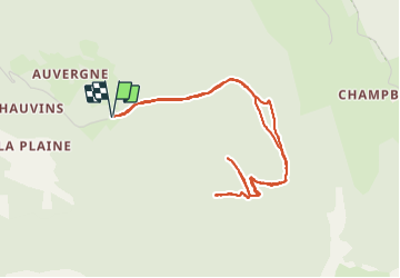
Ruta Senderismo de 5,1 km a descubrir en Auvergne-Rhône-Alpes, Drôme, Vesc. Esta ruta ha sido propuesta por parastat.
Descripción
Pour la descente, au pied de la piste sommitale, je suis parti à gauche: on voit sur la carte une superbe piste qui rejoint le lieu dit-la plaine-
Pas de chance au bout de 200m environ panneau interdiction de passer, j'ai préférer faire demi tour.
Si ça finit comme la montagne d'Angèle, ou il faut demander par écrit une autorisation...
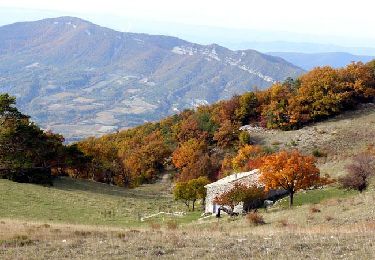
On se croirait au Népal!
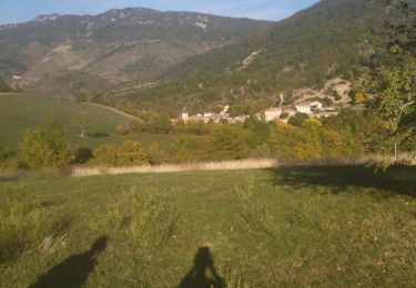
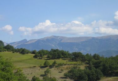
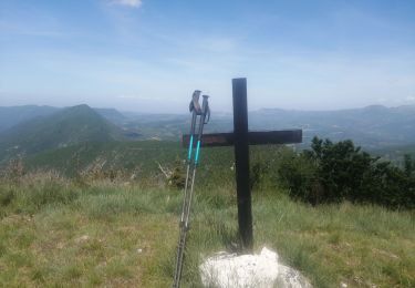
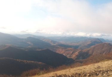
Cela dit le 360° au sommet est superbe.
Localización
Comentarios
Excursiones cerca
![Excursión Senderismo Bouvières - 26 mielandre 09.2023 - Photo](https://media.geolcdn.com/t/375/260/5b567aa0-d7b4-48f7-ae8b-e3567a1c2c82.jpg&format=jpg&maxdim=2)
![Senderismo Senderismo](https://static1.geolcdn.com/sitytour/trail-icons/101.png)
Senderismo
![](/images/other/stat-length.png)
![](https://static1.geolcdn.com/siteimages/upload/files/16400158638029165_repeat_loop_refresh_sync_direction_icon.png)
![Excursión Senderismo Montjoux - 2022-12-16_08h52m12_tmpWriteApidae_48958_fr - Photo](https://media.geolcdn.com/t/375/260/cbc34adf-c509-4a94-9b7f-6317c0990136.jpg&format=jpg&maxdim=2)
![Senderismo Senderismo](https://static1.geolcdn.com/sitytour/trail-icons/101.png)
Senderismo
![](/images/other/stat-length.png)
![](https://static1.geolcdn.com/siteimages/upload/files/16400158638029165_repeat_loop_refresh_sync_direction_icon.png)
![Excursión Senderismo Dieulefit - 2022-09-03_11h49m50_Tour des 3 montagnes 18km.gpx.xml - Photo](https://media.geolcdn.com/t/375/260/14536835-7996-47e3-9b26-05b81d5d9fd5.jpg&format=jpg&maxdim=2)
![Senderismo Senderismo](https://static1.geolcdn.com/sitytour/trail-icons/101.png)
Senderismo
![](/images/other/stat-length.png)
![](https://static1.geolcdn.com/siteimages/upload/files/16400158638029165_repeat_loop_refresh_sync_direction_icon.png)
![Excursión sport Vesc - Wikiloc - Vesc - Photo](https://media.geolcdn.com/t/375/260/ext.jpg?maxdim=2&url=https%3A%2F%2Fsecurestorage.geolives.com%2Fsitytour%2Ftrail-bg%2Fdefault.jpg)
sport
![](/images/other/stat-length.png)
![](https://static1.geolcdn.com/siteimages/upload/files/16400158638029165_repeat_loop_refresh_sync_direction_icon.png)
![Excursión Senderismo Vesc - bec de jus - Photo](https://media.geolcdn.com/t/375/260/a3b29801-cce3-4c4e-ba1d-a04ad4ba01ee.jpg&format=jpg&maxdim=2)
![Senderismo Senderismo](https://static1.geolcdn.com/sitytour/trail-icons/101.png)
Senderismo
![](/images/other/stat-length.png)
![](https://static1.geolcdn.com/siteimages/upload/files/16400158638029165_repeat_loop_refresh_sync_direction_icon.png)
![Excursión Senderismo Valouse - mielandre - Photo](https://media.geolcdn.com/t/375/260/f5718be0-7b70-47ac-8b04-32aa7a492791.jpg&format=jpg&maxdim=2)
![Senderismo Senderismo](https://static1.geolcdn.com/sitytour/trail-icons/101.png)
Senderismo
![](/images/other/stat-length.png)
![](https://static1.geolcdn.com/siteimages/upload/files/16400158638029165_repeat_loop_refresh_sync_direction_icon.png)
![Excursión Senderismo Valouse - 2021_11_14 - Photo](https://media.geolcdn.com/t/375/260/82af798d-3a29-4075-90aa-5e2c8e883cf5.jpg&format=jpg&maxdim=2)
![Senderismo Senderismo](https://static1.geolcdn.com/sitytour/trail-icons/101.png)
Senderismo
![](/images/other/stat-length.png)
![](https://static1.geolcdn.com/siteimages/upload/files/16400158638029165_repeat_loop_refresh_sync_direction_icon.png)
![Excursión Senderismo Valouse - 2021_11_14 Miélandre - Photo](https://media.geolcdn.com/t/375/260/32d9fd14-76e6-4731-8210-b2cb388c409f.jpg&format=jpg&maxdim=2)
![Senderismo Senderismo](https://static1.geolcdn.com/sitytour/trail-icons/101.png)
Senderismo
![](/images/other/stat-length.png)
![](https://static1.geolcdn.com/siteimages/upload/files/16400158638029165_repeat_loop_refresh_sync_direction_icon.png)
![Excursión Senderismo Montjoux - Grottes Sarrazines - Photo](https://media.geolcdn.com/t/375/260/9e204ec0-9863-408e-a6d1-11037647470d.jpg&format=jpg&maxdim=2)
![Senderismo Senderismo](https://static1.geolcdn.com/sitytour/trail-icons/101.png)
Senderismo
![](/images/other/stat-length.png)
![](https://static1.geolcdn.com/siteimages/upload/files/16400158638029165_repeat_loop_refresh_sync_direction_icon.png)