![](/images/other/stat-length.png)
![Excursión Senderismo Risoul - Risoul - Photo](https://media.geolcdn.com/t/1900/400/ext.pjpeg?maxdim=2&url=https%3A%2F%2Fstatic1.geolcdn.com%2Fsiteimages%2Fupload%2Ffiles%2F1553511878bg_sport_marche.png)
Risoul
emileverschueren
Usuario
![Longitud](/images/other/stat-length.png)
![Altitud máxima](https://static1.geolcdn.com/siteimages/upload/files/1508320355ic_sort_altitude_max_24dp.png)
![Desnivel positivo](https://static1.geolcdn.com/siteimages/upload/files/1508320355ic_sort_den_pos_24dp.png)
![Km-Effort](/images/other/stat-length.png)
![Altitud mínima](https://static1.geolcdn.com/siteimages/upload/files/1508320355ic_sort_altitude_min_24dp.png)
![Desnivel negativo](https://static1.geolcdn.com/siteimages/upload/files/1508320355ic_sort_den_neg_24dp.png)
![Boucle](https://static1.geolcdn.com/siteimages/upload/files/16400158638029165_repeat_loop_refresh_sync_direction_icon.png)
![Senderismo](https://static1.geolcdn.com/sitytour/trail-icons/101.png)
12m
Dificultad : Medio
![Escanee este código QR para abrir la excursión en la aplicación SityTrail](https://capi.geolives.com/qq0zvz2zws4bq2lad0pu/sitytour/trails/315636/qr.png?size=200)
Aplicación GPS de excursión GRATIS
A propósito
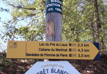
Ruta Senderismo de 7,8 km a descubrir en Provenza-Alpes-Costa Azul, Altos Alpes, Risoul. Esta ruta ha sido propuesta por emileverschueren.
Descripción
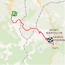
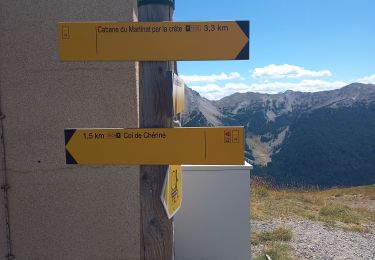
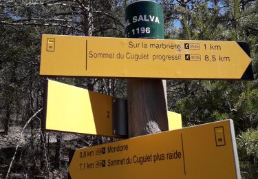
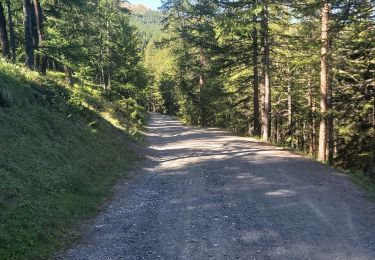
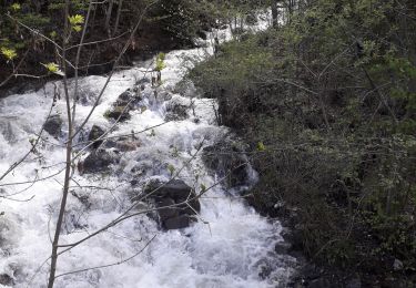
Localité de départRisoulLocalité d'arrivéeSainte-Marie7.781kmAltitude min.1760mAltitude max.2058mDénivelé Tot. 0mDénivelé Tot. -0mActivitéMarcheDifficultéBasseType de solCheminType de parcoursNon officielParcours baliséAucune information.Parcours testé par l'auteurAucune information.
Localización
Comentarios
Excursiones cerca
![Excursión Senderismo Saint-André-d'Embrun - mont Aurel - Photo](https://media.geolcdn.com/t/375/260/43268f02-4aa7-403a-bf4c-3a2f3a5ea0ea.jpg&format=jpg&maxdim=2)
![Senderismo Senderismo](https://static1.geolcdn.com/sitytour/trail-icons/101.png)
Senderismo
![](/images/other/stat-length.png)
![](https://static1.geolcdn.com/siteimages/upload/files/16400158638029165_repeat_loop_refresh_sync_direction_icon.png)
![Excursión Senderismo Vars - Pic de Chabrières 2744m 31.7.22 - Photo](https://media.geolcdn.com/t/375/260/27b448de-709d-4eac-ac4d-b3bdd6c8e895.jpg&format=jpg&maxdim=2)
![Senderismo Senderismo](https://static1.geolcdn.com/sitytour/trail-icons/101.png)
Senderismo
![](/images/other/stat-length.png)
![](https://static1.geolcdn.com/siteimages/upload/files/16400158638029165_repeat_loop_refresh_sync_direction_icon.png)
![Excursión Senderismo Saint-André-d'Embrun - chalet de la biche . mont orel . chapelle de pra leydon . chalet de la coche - Photo](https://media.geolcdn.com/t/375/260/fc8a76ce-7e92-44f8-a3b6-e3a752334a37.jpg&format=jpg&maxdim=2)
![Senderismo Senderismo](https://static1.geolcdn.com/sitytour/trail-icons/101.png)
Senderismo
![](/images/other/stat-length.png)
![](https://static1.geolcdn.com/siteimages/upload/files/16400158638029165_repeat_loop_refresh_sync_direction_icon.png)
![Excursión Senderismo Saint-André-d'Embrun - Chapelle de Pra-Leydon - Les Croix à partir du vallon de Pra-Mouton - Photo](https://media.geolcdn.com/t/375/260/aacec509-0b58-4c91-85a8-3755e48f0d89.jpg&format=jpg&maxdim=2)
![Senderismo Senderismo](https://static1.geolcdn.com/sitytour/trail-icons/101.png)
Senderismo
![](/images/other/stat-length.png)
![](https://static1.geolcdn.com/siteimages/upload/files/16400158638029165_repeat_loop_refresh_sync_direction_icon.png)
![Excursión Senderismo Risoul - Boucle Belvédère de l'homme de Pierre 30.7.22 - Photo](https://media.geolcdn.com/t/375/260/5f406e7b-ed75-411c-854f-9b67e3444588.jpg&format=jpg&maxdim=2)
![Senderismo Senderismo](https://static1.geolcdn.com/sitytour/trail-icons/101.png)
Senderismo
![](/images/other/stat-length.png)
![](https://static1.geolcdn.com/siteimages/upload/files/16400158638029165_repeat_loop_refresh_sync_direction_icon.png)
![Excursión Senderismo Guillestre - Roche Rousse et Rocher de l'aigle à Guillestre - Photo](https://media.geolcdn.com/t/375/260/ef83071a-a3e5-4323-a0d2-2f834a181802.jpg&format=jpg&maxdim=2)
![Senderismo Senderismo](https://static1.geolcdn.com/sitytour/trail-icons/101.png)
Senderismo
![](/images/other/stat-length.png)
![](https://static1.geolcdn.com/siteimages/upload/files/16400158638029165_repeat_loop_refresh_sync_direction_icon.png)
![Excursión Senderismo Risoul - Crêtes de Penon - Photo](https://media.geolcdn.com/t/375/260/14f96927-0740-4f05-9cfe-ba43580669a7.jpg&format=jpg&maxdim=2)
![Senderismo Senderismo](https://static1.geolcdn.com/sitytour/trail-icons/101.png)
Senderismo
![](/images/other/stat-length.png)
![](https://static1.geolcdn.com/siteimages/upload/files/16400158638029165_repeat_loop_refresh_sync_direction_icon.png)
![Excursión Senderismo Risoul - Risoul 1850 Le Villaret - Photo](https://media.geolcdn.com/t/375/260/67eefd3f-ef26-46c7-8d59-a559de4cf6c9.jpg&format=jpg&maxdim=2)
![Senderismo Senderismo](https://static1.geolcdn.com/sitytour/trail-icons/101.png)
Senderismo
![](/images/other/stat-length.png)
![](https://static1.geolcdn.com/siteimages/upload/files/16400158638029165_repeat_loop_refresh_sync_direction_icon.png)
![Excursión Senderismo Risoul - Le Villaret plan Phazy - Photo](https://media.geolcdn.com/t/375/260/cf32f774-53da-40e4-b349-6bec0523a9a8.jpg&format=jpg&maxdim=2)
![Senderismo Senderismo](https://static1.geolcdn.com/sitytour/trail-icons/101.png)
Senderismo
![](/images/other/stat-length.png)
![](https://static1.geolcdn.com/siteimages/upload/files/16400158638029165_repeat_loop_refresh_sync_direction_icon.png)