![](/images/other/stat-length.png)
![Excursión Senderismo Hostun - Hostun Saint Maurice - Photo](https://media.geolcdn.com/t/1900/400/ext.pjpeg?maxdim=2&url=https%3A%2F%2Fstatic1.geolcdn.com%2Fsiteimages%2Fupload%2Ffiles%2F1553511878bg_sport_marche.png)
Hostun Saint Maurice
meillon
Usuario
![Longitud](/images/other/stat-length.png)
Longitud
5,8 km
![Altitud máxima](https://static1.geolcdn.com/siteimages/upload/files/1508320355ic_sort_altitude_max_24dp.png)
Altitud máxima
371 m
![Desnivel positivo](https://static1.geolcdn.com/siteimages/upload/files/1508320355ic_sort_den_pos_24dp.png)
Desnivel positivo
212 m
![Km-Effort](/images/other/stat-length.png)
Km-Effort
8,6 km
![Altitud mínima](https://static1.geolcdn.com/siteimages/upload/files/1508320355ic_sort_altitude_min_24dp.png)
Altitud mínima
240 m
![Desnivel negativo](https://static1.geolcdn.com/siteimages/upload/files/1508320355ic_sort_den_neg_24dp.png)
Desnivel negativo
212 m
![Boucle](https://static1.geolcdn.com/siteimages/upload/files/16400158638029165_repeat_loop_refresh_sync_direction_icon.png)
Boucle
Sí
Fecha de creación :
2022-03-03 13:56:36.231
Última modificación :
2022-03-03 16:02:38.807
![Senderismo](https://static1.geolcdn.com/sitytour/trail-icons/101.png)
2h05
Dificultad : Fácil
![Escanee este código QR para abrir la excursión en la aplicación SityTrail](https://capi.geolives.com/qq0zvz2zws4bq2lad0pu/sitytour/trails/3153677/qr.png?size=200)
Aplicación GPS de excursión GRATIS
A propósito
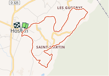
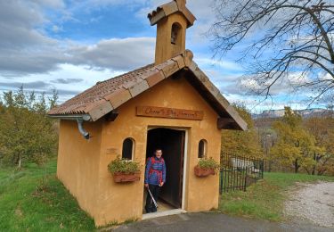
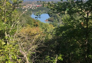
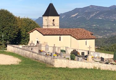
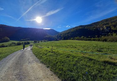
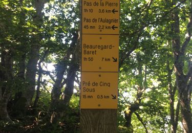
Ruta Senderismo de 5,8 km a descubrir en Auvergne-Rhône-Alpes, Drôme, Hostun. Esta ruta ha sido propuesta por meillon.
Descripción
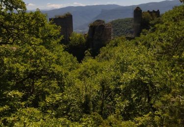
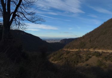
En longeant les monts du matin. Chateau féodal charmant, eglise Szint Martin et sa place avec fontaine. Vue sur la vallée de l isere.
Localización
País:
France
Región :
Auvergne-Rhône-Alpes
Departamento/provincia :
Drôme
Municipio :
Hostun
Localidad:
Unknown
Salida:(Dec)
Salida:(UTM)
673311 ; 4989553 (31T) N.
Comentarios
Excursiones cerca
![Excursión Senderismo Beauregard-Baret - reco cx st Gervais b baret - Photo](https://media.geolcdn.com/t/375/260/62f4b6af-f36d-4d7e-9bf7-cff82879ff65.jpg&format=jpg&maxdim=2)
![Senderismo Senderismo](https://static1.geolcdn.com/sitytour/trail-icons/101.png)
reco cx st Gervais b baret
Senderismo
Difícil
Beauregard-Baret,
Auvergne-Rhône-Alpes,
Drôme,
France
![](/images/other/stat-length.png)
9,4 km | 16,2 km-effort
4h 58min
![](https://static1.geolcdn.com/siteimages/upload/files/16400158638029165_repeat_loop_refresh_sync_direction_icon.png)
No
![Excursión Senderismo Saint-Nazaire-en-Royans - Saint Nazaire en Royans - Photo](https://media.geolcdn.com/t/375/260/9a4745be-ac4b-40db-8413-c6fc1c70305f.jpg&format=jpg&maxdim=2)
![Senderismo Senderismo](https://static1.geolcdn.com/sitytour/trail-icons/101.png)
Saint Nazaire en Royans
Senderismo
Medio
Saint-Nazaire-en-Royans,
Auvergne-Rhône-Alpes,
Drôme,
France
![](/images/other/stat-length.png)
5,9 km | 10,3 km-effort
2h 32min
![](https://static1.geolcdn.com/siteimages/upload/files/16400158638029165_repeat_loop_refresh_sync_direction_icon.png)
Sí
![Excursión Senderismo Saint-Nazaire-en-Royans - 26 rochechinard - Photo](https://media.geolcdn.com/t/375/260/64bebd3a-cf7b-4175-b0a0-941e7f9a3dc8.jpg&format=jpg&maxdim=2)
![Senderismo Senderismo](https://static1.geolcdn.com/sitytour/trail-icons/101.png)
26 rochechinard
Senderismo
Fácil
Saint-Nazaire-en-Royans,
Auvergne-Rhône-Alpes,
Drôme,
France
![](/images/other/stat-length.png)
8,3 km | 14,4 km-effort
3h 5min
![](https://static1.geolcdn.com/siteimages/upload/files/16400158638029165_repeat_loop_refresh_sync_direction_icon.png)
No
![Excursión Senderismo Saint-Nazaire-en-Royans - château de Rochechinard - Photo](https://media.geolcdn.com/t/375/260/c828170a-051c-4786-8dbf-e0a1d1f76059.jpg&format=jpg&maxdim=2)
![Senderismo Senderismo](https://static1.geolcdn.com/sitytour/trail-icons/101.png)
château de Rochechinard
Senderismo
Medio
Saint-Nazaire-en-Royans,
Auvergne-Rhône-Alpes,
Drôme,
France
![](/images/other/stat-length.png)
14,2 km | 22 km-effort
6h 53min
![](https://static1.geolcdn.com/siteimages/upload/files/16400158638029165_repeat_loop_refresh_sync_direction_icon.png)
Sí
![Excursión Senderismo Saint-Nazaire-en-Royans - St Nazaire en Royans - Photo](https://media.geolcdn.com/t/375/260/538fa533-b020-4c56-a198-a4846769d378.jpg&format=jpg&maxdim=2)
![Senderismo Senderismo](https://static1.geolcdn.com/sitytour/trail-icons/101.png)
St Nazaire en Royans
Senderismo
Difícil
Saint-Nazaire-en-Royans,
Auvergne-Rhône-Alpes,
Drôme,
France
![](/images/other/stat-length.png)
12,3 km | 19 km-effort
2h 49min
![](https://static1.geolcdn.com/siteimages/upload/files/16400158638029165_repeat_loop_refresh_sync_direction_icon.png)
Sí
![Excursión Senderismo Rochechinard - Rochechinard la Ragnole les Berthonettes - Photo](https://media.geolcdn.com/t/375/260/eb114973-ed3b-48be-acc9-8ba47652e0e1.jpg&format=jpg&maxdim=2)
![Senderismo Senderismo](https://static1.geolcdn.com/sitytour/trail-icons/101.png)
Rochechinard la Ragnole les Berthonettes
Senderismo
Fácil
(1)
Rochechinard,
Auvergne-Rhône-Alpes,
Drôme,
France
![](/images/other/stat-length.png)
12,1 km | 18,9 km-effort
2h 55min
![](https://static1.geolcdn.com/siteimages/upload/files/16400158638029165_repeat_loop_refresh_sync_direction_icon.png)
Sí
![Excursión Senderismo Rochechinard - Chateau de Rochechinard - Photo](https://media.geolcdn.com/t/375/260/437f04f8-c584-4410-9de2-2a66f532620f.jpg&format=jpg&maxdim=2)
![Senderismo Senderismo](https://static1.geolcdn.com/sitytour/trail-icons/101.png)
Chateau de Rochechinard
Senderismo
Muy fácil
Rochechinard,
Auvergne-Rhône-Alpes,
Drôme,
France
![](/images/other/stat-length.png)
4,3 km | 6,7 km-effort
1h 57min
![](https://static1.geolcdn.com/siteimages/upload/files/16400158638029165_repeat_loop_refresh_sync_direction_icon.png)
Sí
![Excursión Senderismo Beauregard-Baret - Pas de la pierre par le Col des Tourniers - Photo](https://media.geolcdn.com/t/375/260/52294e58-e9d6-4383-99f3-e61f7e4bc941.jpg&format=jpg&maxdim=2)
![Senderismo Senderismo](https://static1.geolcdn.com/sitytour/trail-icons/101.png)
Pas de la pierre par le Col des Tourniers
Senderismo
Difícil
Beauregard-Baret,
Auvergne-Rhône-Alpes,
Drôme,
France
![](/images/other/stat-length.png)
11,1 km | 21 km-effort
3h 22min
![](https://static1.geolcdn.com/siteimages/upload/files/16400158638029165_repeat_loop_refresh_sync_direction_icon.png)
Sí
![Excursión Senderismo Rochechinard - Pré 5 sous, retour par le chateau - Photo](https://media.geolcdn.com/t/375/260/6fc17380-915a-4460-9d35-48f0f2f8d9c0.jpg&format=jpg&maxdim=2)
![Senderismo Senderismo](https://static1.geolcdn.com/sitytour/trail-icons/101.png)
Pré 5 sous, retour par le chateau
Senderismo
Medio
Rochechinard,
Auvergne-Rhône-Alpes,
Drôme,
France
![](/images/other/stat-length.png)
17,3 km | 30 km-effort
5h 35min
![](https://static1.geolcdn.com/siteimages/upload/files/16400158638029165_repeat_loop_refresh_sync_direction_icon.png)
Sí