![](/images/other/stat-length.png)
![Excursión Senderismo Garrigues - garrigues-Bois et grotte de Paris - Photo](https://media.geolcdn.com/t/1900/400/4b81bf27-8473-4beb-a1d2-9480527ae00d.jpg&format=pjpeg&maxdim=2)
garrigues-Bois et grotte de Paris
v.rabot
Usuario
![Longitud](/images/other/stat-length.png)
![Altitud máxima](https://static1.geolcdn.com/siteimages/upload/files/1508320355ic_sort_altitude_max_24dp.png)
![Desnivel positivo](https://static1.geolcdn.com/siteimages/upload/files/1508320355ic_sort_den_pos_24dp.png)
![Km-Effort](/images/other/stat-length.png)
![Altitud mínima](https://static1.geolcdn.com/siteimages/upload/files/1508320355ic_sort_altitude_min_24dp.png)
![Desnivel negativo](https://static1.geolcdn.com/siteimages/upload/files/1508320355ic_sort_den_neg_24dp.png)
![Boucle](https://static1.geolcdn.com/siteimages/upload/files/16400158638029165_repeat_loop_refresh_sync_direction_icon.png)
![Senderismo](https://static1.geolcdn.com/sitytour/trail-icons/101.png)
4h58
Dificultad : Medio
![Escanee este código QR para abrir la excursión en la aplicación SityTrail](https://capi.geolives.com/qq0zvz2zws4bq2lad0pu/sitytour/trails/3142397/qr.png?size=200)
Aplicación GPS de excursión GRATIS
A propósito
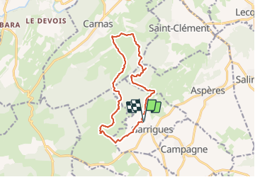
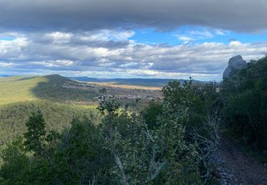
Ruta Senderismo de 14,2 km a descubrir en Occitania, Hérault, Garrigues. Esta ruta ha sido propuesta por v.rabot.
Descripción
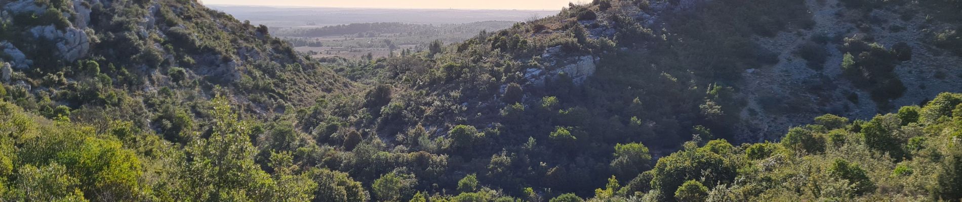
Randonnée ne présentant aucune difficultée en dehors de quelques passages assez caillouteux nécessitant de bonnes chaussures et des bâtons pour les plus anciens. La descente dans la grotte n'offre aucune difficulté, rampes et escalier, pensez à prendre une lampe. Il faut aller au fond de la grotte pour voir les concrétions. Randonnée à ne pas faire à la saison chaude, cela doit cogner dur.
Localización
Comentarios
Excursiones cerca
![Excursión Senderismo Carnas - Carnas bois de Paris - Photo](https://media.geolcdn.com/t/375/260/ext.jpg?maxdim=2&url=https%3A%2F%2Fservices.sitytrail.com%2FGeolivesWS%2FDownloadMedia.ashx%3FTrailID%3D178653%26Media%3D20130304133341.jpeg)
![Senderismo Senderismo](https://static1.geolcdn.com/sitytour/trail-icons/101.png)
Senderismo
![](/images/other/stat-length.png)
![](https://static1.geolcdn.com/siteimages/upload/files/16400158638029165_repeat_loop_refresh_sync_direction_icon.png)
![Excursión Senderismo Saussines - Saussines - Photo](https://media.geolcdn.com/t/375/260/ext.jpg?maxdim=2&url=https%3A%2F%2Fstatic1.geolcdn.com%2Fsiteimages%2Fupload%2Ffiles%2F1553511878bg_sport_marche.png)
![Senderismo Senderismo](https://static1.geolcdn.com/sitytour/trail-icons/101.png)
Senderismo
![](/images/other/stat-length.png)
![](https://static1.geolcdn.com/siteimages/upload/files/16400158638029165_repeat_loop_refresh_sync_direction_icon.png)
![Excursión Senderismo Saint-Clément - Le bois de Paris - Grotte, Table d'orientation, Oppidum - Photo](https://media.geolcdn.com/t/375/260/ext.jpg?maxdim=2&url=https%3A%2F%2Fstatic1.geolcdn.com%2Fsiteimages%2Fupload%2Ffiles%2F1553511878bg_sport_marche.png)
![Senderismo Senderismo](https://static1.geolcdn.com/sitytour/trail-icons/101.png)
Senderismo
![](/images/other/stat-length.png)
![](https://static1.geolcdn.com/siteimages/upload/files/16400158638029165_repeat_loop_refresh_sync_direction_icon.png)
![Excursión Senderismo Aspères - Aspères - Photo](https://media.geolcdn.com/t/375/260/3aa1cad7-a037-4103-94ea-4f508e99c3ef.jpg&format=jpg&maxdim=2)
![Senderismo Senderismo](https://static1.geolcdn.com/sitytour/trail-icons/101.png)
![Excursión Senderismo Saussines - Circuit des capot elles - Photo](https://media.geolcdn.com/t/375/260/6f4a9959-1f02-425b-b581-c3419555dbfc.jpg&format=jpg&maxdim=2)
![Senderismo Senderismo](https://static1.geolcdn.com/sitytour/trail-icons/101.png)
Senderismo
![](/images/other/stat-length.png)
![](https://static1.geolcdn.com/siteimages/upload/files/16400158638029165_repeat_loop_refresh_sync_direction_icon.png)
![Excursión Senderismo Salinelles - salinelles-pondres-souvignargues-fontanes - Photo](https://media.geolcdn.com/t/375/260/1607f42f-3da2-4ff5-8f21-3a0fa46d978d.jpg&format=jpg&maxdim=2)
![Senderismo Senderismo](https://static1.geolcdn.com/sitytour/trail-icons/101.png)
Senderismo
![](/images/other/stat-length.png)
![](https://static1.geolcdn.com/siteimages/upload/files/16400158638029165_repeat_loop_refresh_sync_direction_icon.png)
![Excursión Senderismo Saint-Bauzille-de-Montmel - Puech des Mourgues - Photo](https://media.geolcdn.com/t/375/260/778d0258-477b-444e-94ad-029be09d1018.jpg&format=jpg&maxdim=2)
![Senderismo Senderismo](https://static1.geolcdn.com/sitytour/trail-icons/101.png)
Senderismo
![](/images/other/stat-length.png)
![](https://static1.geolcdn.com/siteimages/upload/files/16400158638029165_repeat_loop_refresh_sync_direction_icon.png)
![Excursión Senderismo Aspères - Aspères - Photo](https://media.geolcdn.com/t/375/260/066f7f1d-8ada-4c66-8b3d-d6874a67ba86.jpg&format=jpg&maxdim=2)
![Senderismo Senderismo](https://static1.geolcdn.com/sitytour/trail-icons/101.png)
![Excursión Senderismo Saussines - Saussines et ses capitelles - Photo](https://media.geolcdn.com/t/375/260/0e3f4dc9-b3d2-4dd3-b56c-054def4dec10.jpg&format=jpg&maxdim=2)
![Senderismo Senderismo](https://static1.geolcdn.com/sitytour/trail-icons/101.png)
Senderismo
![](/images/other/stat-length.png)
![](https://static1.geolcdn.com/siteimages/upload/files/16400158638029165_repeat_loop_refresh_sync_direction_icon.png)