![](/images/other/stat-length.png)
![Excursión A pie Ockenfels - LZ15 - Rundwanderweg Ockenfels - Photo](https://media.geolcdn.com/t/1900/400/ext.pjpeg?maxdim=2&url=https%3A%2F%2Fstatic1.geolcdn.com%2Fsiteimages%2Fupload%2Ffiles%2F1545311037marcheuse_200dpi.jpg)
LZ15 - Rundwanderweg Ockenfels
SityTrail - itinéraires balisés pédestres
Tous les sentiers balisés d’Europe PRO
![Longitud](/images/other/stat-length.png)
Longitud
6,2 km
![Altitud máxima](https://static1.geolcdn.com/siteimages/upload/files/1508320355ic_sort_altitude_max_24dp.png)
Altitud máxima
257 m
![Desnivel positivo](https://static1.geolcdn.com/siteimages/upload/files/1508320355ic_sort_den_pos_24dp.png)
Desnivel positivo
146 m
![Km-Effort](/images/other/stat-length.png)
Km-Effort
8,1 km
![Altitud mínima](https://static1.geolcdn.com/siteimages/upload/files/1508320355ic_sort_altitude_min_24dp.png)
Altitud mínima
153 m
![Desnivel negativo](https://static1.geolcdn.com/siteimages/upload/files/1508320355ic_sort_den_neg_24dp.png)
Desnivel negativo
142 m
![Boucle](https://static1.geolcdn.com/siteimages/upload/files/16400158638029165_repeat_loop_refresh_sync_direction_icon.png)
Boucle
Sí
Baliza
Fecha de creación :
2022-02-21 08:29:13.555
Última modificación :
2022-02-21 08:29:13.555
![A pie](https://static1.geolcdn.com/sitytour/trail-icons/100.png)
1h51
Dificultad : Fácil
![Escanee este código QR para abrir la excursión en la aplicación SityTrail](https://capi.geolives.com/qq0zvz2zws4bq2lad0pu/sitytour/trails/3137337/qr.png?size=200)
Aplicación GPS de excursión GRATIS
A propósito
Ruta A pie de 6,2 km a descubrir en Renania-Palatinado, Landkreis Neuwied, Ockenfels. Esta ruta ha sido propuesta por SityTrail - itinéraires balisés pédestres.
Descripción
Trail created by Verbandsgemeinde Linz am Rhein.
Symbol: weisses LZ15 auf rotem Grund
Localización
País:
Germany
Región :
Renania-Palatinado
Departamento/provincia :
Landkreis Neuwied
Municipio :
Ockenfels
Localidad:
Unknown
Salida:(Dec)
Salida:(UTM)
378218 ; 5603804 (32U) N.
Comentarios
Excursiones cerca
![Excursión A pie Bruchhausen - Rotbäckchen Rundwanderweg - Photo](https://media.geolcdn.com/t/375/260/ext.jpg?maxdim=2&url=https%3A%2F%2Fmedia.geolcdn.com%2Ff%2F1dd5c4a7-c3a6-459c-9cef-b7e5315b6005.jpeg)
![A pie A pie](https://static1.geolcdn.com/sitytour/trail-icons/100.png)
Rotbäckchen Rundwanderweg
A pie
Fácil
Bruchhausen,
Renania-Palatinado,
Landkreis Neuwied,
Germany
![](/images/other/stat-length.png)
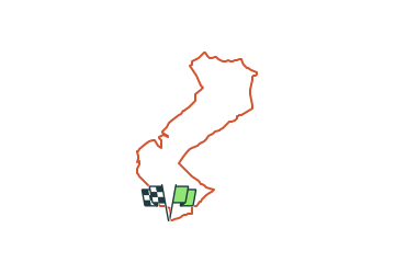
11,1 km | 14,1 km-effort
3h 11min
![](https://static1.geolcdn.com/siteimages/upload/files/16400158638029165_repeat_loop_refresh_sync_direction_icon.png)
Sí
![Excursión A pie Remagen - Apollinaris-Schleife (Rheinburgenweg Rundtour) - Photo](https://media.geolcdn.com/t/375/260/ext.jpg?maxdim=2&url=https%3A%2F%2Fmedia.geolcdn.com%2Ff%2Fafe28d54-8362-474d-8d66-b77f50c689dd.jpeg)
![A pie A pie](https://static1.geolcdn.com/sitytour/trail-icons/100.png)
Apollinaris-Schleife (Rheinburgenweg Rundtour)
A pie
Fácil
Remagen,
Renania-Palatinado,
Landkreis Ahrweiler,
Germany
![](/images/other/stat-length.png)
12,7 km | 16,4 km-effort
3h 43min
![](https://static1.geolcdn.com/siteimages/upload/files/16400158638029165_repeat_loop_refresh_sync_direction_icon.png)
Sí
![Excursión A pie Vettelschoß - Rheinsteig-Zuweg Kalenborn - Photo](https://media.geolcdn.com/t/375/260/ext.jpg?maxdim=2&url=https%3A%2F%2Fmedia.geolcdn.com%2Ff%2Fc07369c5-ba12-49ff-983d-a7ba9bba008e.jpeg)
![A pie A pie](https://static1.geolcdn.com/sitytour/trail-icons/100.png)
Rheinsteig-Zuweg Kalenborn
A pie
Fácil
Vettelschoß,
Renania-Palatinado,
Landkreis Neuwied,
Germany
![](/images/other/stat-length.png)
7,5 km | 9,3 km-effort
2h 6min
![](https://static1.geolcdn.com/siteimages/upload/files/16400158638029165_repeat_loop_refresh_sync_direction_icon.png)
No
![Excursión A pie Sinzig - Rundweg 7 Bad Bodendorf - Photo](https://media.geolcdn.com/t/375/260/ext.jpg?maxdim=2&url=https%3A%2F%2Fmedia.geolcdn.com%2Ff%2Fd3fff6ae-8a86-4233-9da6-73de21a37b8c.jpeg)
![A pie A pie](https://static1.geolcdn.com/sitytour/trail-icons/100.png)
Rundweg 7 Bad Bodendorf
A pie
Fácil
Sinzig,
Renania-Palatinado,
Landkreis Ahrweiler,
Germany
![](/images/other/stat-length.png)
8,8 km | 11,1 km-effort
2h 30min
![](https://static1.geolcdn.com/siteimages/upload/files/16400158638029165_repeat_loop_refresh_sync_direction_icon.png)
Sí
![Excursión A pie Remagen - DE-A3 - Photo](https://media.geolcdn.com/t/375/260/ext.jpg?maxdim=2&url=https%3A%2F%2Fmedia.geolcdn.com%2Ff%2F5e7c6f42-f88c-4062-9277-171320514dad.jpeg)
![A pie A pie](https://static1.geolcdn.com/sitytour/trail-icons/100.png)
DE-A3
A pie
Fácil
Remagen,
Renania-Palatinado,
Landkreis Ahrweiler,
Germany
![](/images/other/stat-length.png)
4,7 km | 6,3 km-effort
1h 26min
![](https://static1.geolcdn.com/siteimages/upload/files/16400158638029165_repeat_loop_refresh_sync_direction_icon.png)
Sí
![Excursión A pie Linz am Rhein - LZ13 - Rundwanderweg Minderberg - Photo](https://media.geolcdn.com/t/375/260/ext.jpg?maxdim=2&url=https%3A%2F%2Fstatic1.geolcdn.com%2Fsiteimages%2Fupload%2Ffiles%2F1545311037marcheuse_200dpi.jpg)
![A pie A pie](https://static1.geolcdn.com/sitytour/trail-icons/100.png)
LZ13 - Rundwanderweg Minderberg
A pie
Fácil
Linz am Rhein,
Renania-Palatinado,
Landkreis Neuwied,
Germany
![](/images/other/stat-length.png)
5,1 km | 7,2 km-effort
1h 37min
![](https://static1.geolcdn.com/siteimages/upload/files/16400158638029165_repeat_loop_refresh_sync_direction_icon.png)
Sí
![Excursión A pie Vettelschoß - LZ11 - Rundwanderweg Kalenborn - Photo](https://media.geolcdn.com/t/375/260/ext.jpg?maxdim=2&url=https%3A%2F%2Fstatic1.geolcdn.com%2Fsiteimages%2Fupload%2Ffiles%2F1545311037marcheuse_200dpi.jpg)
![A pie A pie](https://static1.geolcdn.com/sitytour/trail-icons/100.png)
LZ11 - Rundwanderweg Kalenborn
A pie
Fácil
Vettelschoß,
Renania-Palatinado,
Landkreis Neuwied,
Germany
![](/images/other/stat-length.png)
4,2 km | 5,4 km-effort
1h 14min
![](https://static1.geolcdn.com/siteimages/upload/files/16400158638029165_repeat_loop_refresh_sync_direction_icon.png)
Sí
![Excursión A pie Sankt Katharinen - LZ10 - Rundwanderweg Homscheid - Photo](https://media.geolcdn.com/t/375/260/ext.jpg?maxdim=2&url=https%3A%2F%2Fstatic1.geolcdn.com%2Fsiteimages%2Fupload%2Ffiles%2F1545311037marcheuse_200dpi.jpg)
![A pie A pie](https://static1.geolcdn.com/sitytour/trail-icons/100.png)
LZ10 - Rundwanderweg Homscheid
A pie
Fácil
Sankt Katharinen,
Renania-Palatinado,
Landkreis Neuwied,
Germany
![](/images/other/stat-length.png)
6 km | 7,9 km-effort
1h 48min
![](https://static1.geolcdn.com/siteimages/upload/files/16400158638029165_repeat_loop_refresh_sync_direction_icon.png)
Sí
![Excursión A pie Sankt Katharinen - LZ9 - Rundwanderweg Lorscheid - Strödt - Photo](https://media.geolcdn.com/t/375/260/ext.jpg?maxdim=2&url=https%3A%2F%2Fstatic1.geolcdn.com%2Fsiteimages%2Fupload%2Ffiles%2F1545311037marcheuse_200dpi.jpg)
![A pie A pie](https://static1.geolcdn.com/sitytour/trail-icons/100.png)
LZ9 - Rundwanderweg Lorscheid - Strödt
A pie
Fácil
Sankt Katharinen,
Renania-Palatinado,
Landkreis Neuwied,
Germany
![](/images/other/stat-length.png)
8,7 km | 11,6 km-effort
2h 38min
![](https://static1.geolcdn.com/siteimages/upload/files/16400158638029165_repeat_loop_refresh_sync_direction_icon.png)
Sí