![](/images/other/stat-length.png)
![Excursión Senderismo Saint-Héand - Rando-ST Héand 20_02_22 - Photo](https://media.geolcdn.com/t/1900/400/ext.pjpeg?maxdim=2&url=https%3A%2F%2Fstatic1.geolcdn.com%2Fsiteimages%2Fupload%2Ffiles%2F1553511878bg_sport_marche.png)
Rando-ST Héand 20_02_22
acsglaurent
Usuario
![Longitud](/images/other/stat-length.png)
Longitud
10,2 km
![Altitud máxima](https://static1.geolcdn.com/siteimages/upload/files/1508320355ic_sort_altitude_max_24dp.png)
Altitud máxima
873 m
![Desnivel positivo](https://static1.geolcdn.com/siteimages/upload/files/1508320355ic_sort_den_pos_24dp.png)
Desnivel positivo
290 m
![Km-Effort](/images/other/stat-length.png)
Km-Effort
14,1 km
![Altitud mínima](https://static1.geolcdn.com/siteimages/upload/files/1508320355ic_sort_altitude_min_24dp.png)
Altitud mínima
659 m
![Desnivel negativo](https://static1.geolcdn.com/siteimages/upload/files/1508320355ic_sort_den_neg_24dp.png)
Desnivel negativo
286 m
![Boucle](https://static1.geolcdn.com/siteimages/upload/files/16400158638029165_repeat_loop_refresh_sync_direction_icon.png)
Boucle
Sí
Fecha de creación :
2022-02-20 13:43:26.773
Última modificación :
2022-02-21 17:37:29.208
![Senderismo](https://static1.geolcdn.com/sitytour/trail-icons/101.png)
3h08
Dificultad : Medio
![Escanee este código QR para abrir la excursión en la aplicación SityTrail](https://capi.geolives.com/qq0zvz2zws4bq2lad0pu/sitytour/trails/3135915/qr.png?size=200)
Aplicación GPS de excursión GRATIS
A propósito
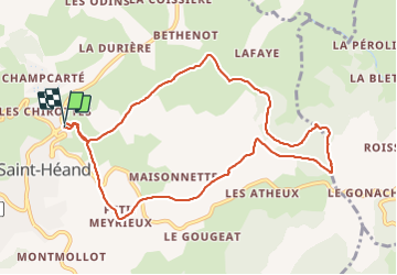
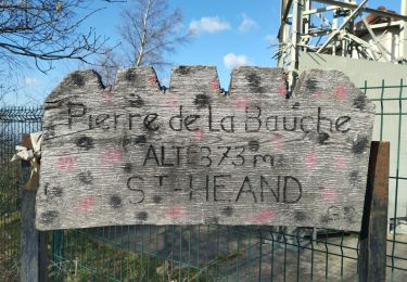
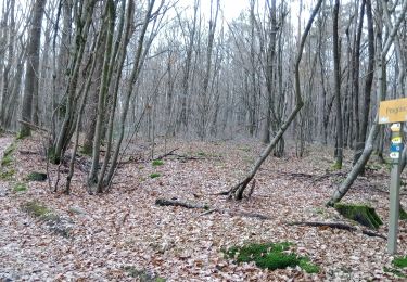
Ruta Senderismo de 10,2 km a descubrir en Auvergne-Rhône-Alpes, Loira, Saint-Héand. Esta ruta ha sido propuesta por acsglaurent.
Descripción
Départ parking plan d'eau et boucle en passant par les antennes
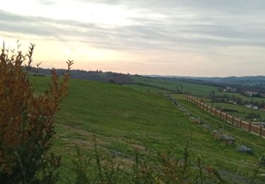
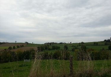
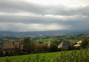
Si temps claire vu sur les Alpes et le mont Blanc
Localización
País:
France
Región :
Auvergne-Rhône-Alpes
Departamento/provincia :
Loira
Municipio :
Saint-Héand
Localidad:
Unknown
Salida:(Dec)
Salida:(UTM)
607639 ; 5043222 (31T) N.
Comentarios
Excursiones cerca
![Excursión Senderismo Saint-Héand - St Heand, Montrond, Mont Morin, Pierre de la Bauche et retour St Heand - Photo](https://media.geolcdn.com/t/375/260/ext.jpg?maxdim=2&url=https%3A%2F%2Fstatic1.geolcdn.com%2Fsiteimages%2Fupload%2Ffiles%2F1553511878bg_sport_marche.png)
![Senderismo Senderismo](https://static1.geolcdn.com/sitytour/trail-icons/101.png)
St Heand, Montrond, Mont Morin, Pierre de la Bauche et retour St Heand
Senderismo
Medio
(1)
Saint-Héand,
Auvergne-Rhône-Alpes,
Loira,
France
![](/images/other/stat-length.png)
16 km | 23 km-effort
5h 20min
![](https://static1.geolcdn.com/siteimages/upload/files/16400158638029165_repeat_loop_refresh_sync_direction_icon.png)
Sí
![Excursión Senderismo Saint-Bonnet-les-Oules - Saint-Bonnet-les-Oules du 26-12-2022 - Photo](https://media.geolcdn.com/t/375/260/b0909c52-48d0-4fb3-a021-6e2066fe45fd.jpg&format=jpg&maxdim=2)
![Senderismo Senderismo](https://static1.geolcdn.com/sitytour/trail-icons/101.png)
Saint-Bonnet-les-Oules du 26-12-2022
Senderismo
Difícil
Saint-Bonnet-les-Oules,
Auvergne-Rhône-Alpes,
Loira,
France
![](/images/other/stat-length.png)
10,8 km | 14,5 km-effort
2h 17min
![](https://static1.geolcdn.com/siteimages/upload/files/16400158638029165_repeat_loop_refresh_sync_direction_icon.png)
Sí
![Excursión Senderismo Sorbiers - sorbiers 23/2 - Photo](https://media.geolcdn.com/t/375/260/ext.jpg?maxdim=2&url=https%3A%2F%2Fstatic1.geolcdn.com%2Fsiteimages%2Fupload%2Ffiles%2F1553511878bg_sport_marche.png)
![Senderismo Senderismo](https://static1.geolcdn.com/sitytour/trail-icons/101.png)
sorbiers 23/2
Senderismo
Difícil
(1)
Sorbiers,
Auvergne-Rhône-Alpes,
Loira,
France
![](/images/other/stat-length.png)
23 km | 35 km-effort
4h 36min
![](https://static1.geolcdn.com/siteimages/upload/files/16400158638029165_repeat_loop_refresh_sync_direction_icon.png)
Sí
![Excursión Senderismo Sorbiers - sorbiers - Photo](https://media.geolcdn.com/t/375/260/ext.jpg?maxdim=2&url=https%3A%2F%2Fstatic1.geolcdn.com%2Fsiteimages%2Fupload%2Ffiles%2F1553511878bg_sport_marche.png)
![Senderismo Senderismo](https://static1.geolcdn.com/sitytour/trail-icons/101.png)
sorbiers
Senderismo
Difícil
(1)
Sorbiers,
Auvergne-Rhône-Alpes,
Loira,
France
![](/images/other/stat-length.png)
23 km | 36 km-effort
4h 46min
![](https://static1.geolcdn.com/siteimages/upload/files/16400158638029165_repeat_loop_refresh_sync_direction_icon.png)
Sí
![Excursión Senderismo Sorbiers - sorbiers-st christo - valfeury - Photo](https://media.geolcdn.com/t/375/260/ext.jpg?maxdim=2&url=https%3A%2F%2Fstatic1.geolcdn.com%2Fsiteimages%2Fupload%2Ffiles%2F1553511878bg_sport_marche.png)
![Senderismo Senderismo](https://static1.geolcdn.com/sitytour/trail-icons/101.png)
sorbiers-st christo - valfeury
Senderismo
Medio
(1)
Sorbiers,
Auvergne-Rhône-Alpes,
Loira,
France
![](/images/other/stat-length.png)
23 km | 35 km-effort
4h 32min
![](https://static1.geolcdn.com/siteimages/upload/files/16400158638029165_repeat_loop_refresh_sync_direction_icon.png)
Sí
![Excursión Senderismo Saint-Héand - izzy - Photo](https://media.geolcdn.com/t/375/260/ext.jpg?maxdim=2&url=https%3A%2F%2Fservices.sitytrail.com%2FGeolivesWS%2FDownloadMedia.ashx%3FTrailID%3D230294%26Media%3Dfix__20131101155052.jpg)
![Senderismo Senderismo](https://static1.geolcdn.com/sitytour/trail-icons/101.png)
izzy
Senderismo
Fácil
Saint-Héand,
Auvergne-Rhône-Alpes,
Loira,
France
![](/images/other/stat-length.png)
5,9 km | 8,1 km-effort
1h 10min
![](https://static1.geolcdn.com/siteimages/upload/files/16400158638029165_repeat_loop_refresh_sync_direction_icon.png)
Sí
![Excursión Senderismo Saint-Héand - tour de st heand - Photo](https://media.geolcdn.com/t/375/260/ext.jpg?maxdim=2&url=https%3A%2F%2Fservices.sitytrail.com%2FGeolivesWS%2FDownloadMedia.ashx%3FTrailID%3D158199%26Media%3D20121014153946.jpeg)
![Senderismo Senderismo](https://static1.geolcdn.com/sitytour/trail-icons/101.png)
tour de st heand
Senderismo
Muy fácil
Saint-Héand,
Auvergne-Rhône-Alpes,
Loira,
France
![](/images/other/stat-length.png)
13,2 km | 18,3 km-effort
3h 15min
![](https://static1.geolcdn.com/siteimages/upload/files/16400158638029165_repeat_loop_refresh_sync_direction_icon.png)
Sí
![Excursión Senderismo Saint-Héand - Saint-héand, la pierre de la bauche, les alisiers, le rivollier, les baraques, Saint-héand - Photo](https://media.geolcdn.com/t/375/260/a6cd303b-9223-49c8-a72d-e215cf50d4f5.jpg&format=jpg&maxdim=2)
![Senderismo Senderismo](https://static1.geolcdn.com/sitytour/trail-icons/101.png)
Saint-héand, la pierre de la bauche, les alisiers, le rivollier, les baraques...
Senderismo
Medio
Saint-Héand,
Auvergne-Rhône-Alpes,
Loira,
France
![](/images/other/stat-length.png)
12,3 km | 17,8 km-effort
2h 53min
![](https://static1.geolcdn.com/siteimages/upload/files/16400158638029165_repeat_loop_refresh_sync_direction_icon.png)
Sí
![Excursión Senderismo La Fouillouse - la Fouillouse du 23-12-2022 - Photo](https://media.geolcdn.com/t/375/260/6bb4cea8-ed48-4347-8677-7ad69837607c.jpg&format=jpg&maxdim=2)
![Senderismo Senderismo](https://static1.geolcdn.com/sitytour/trail-icons/101.png)
la Fouillouse du 23-12-2022
Senderismo
Difícil
La Fouillouse,
Auvergne-Rhône-Alpes,
Loira,
France
![](/images/other/stat-length.png)
11 km | 14,7 km-effort
2h 24min
![](https://static1.geolcdn.com/siteimages/upload/files/16400158638029165_repeat_loop_refresh_sync_direction_icon.png)
Sí