


9,2 km | 10,9 km-effort


Usuario


Aplicación GPS de excursión GRATIS
 SityTrail
IGN / Institutos geográficos
SityTrail World
El mundo es suyo
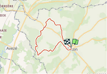
Ruta Senderismo de 12,2 km a descubrir en Normandía, Orne, Ceton. Esta ruta ha sido propuesta por ODDAD78.
Une randonnée qui vous permettra de partir à la découverte des alentours de Ceton et qui offre de nombreux points de vue sur la campagne percheronne.
Une version plus complète, mais plus longue est disponible ici :
https://rando-perche.fr/a-pied/le-prieure-st-pierre-es-liens/
 "
data-pinterest-text="Pin it"
data-tweet-text="share on twitter"
data-facebook-share-url="https://www.sitytrail.com/es/trails/3135799-ceton--ceton-x-une-version-raccourcie-du-xprieure-saintxpierrexesxlien-12-km/?photo=1#lg=1&slide=1"
data-twitter-share-url="https://www.sitytrail.com/es/trails/3135799-ceton--ceton-x-une-version-raccourcie-du-xprieure-saintxpierrexesxlien-12-km/?photo=1#lg=1&slide=1"
data-googleplus-share-url="https://www.sitytrail.com/es/trails/3135799-ceton--ceton-x-une-version-raccourcie-du-xprieure-saintxpierrexesxlien-12-km/?photo=1#lg=1&slide=1"
data-pinterest-share-url="https://www.sitytrail.com/es/trails/3135799-ceton--ceton-x-une-version-raccourcie-du-xprieure-saintxpierrexesxlien-12-km/?photo=1#lg=1&slide=1">
"
data-pinterest-text="Pin it"
data-tweet-text="share on twitter"
data-facebook-share-url="https://www.sitytrail.com/es/trails/3135799-ceton--ceton-x-une-version-raccourcie-du-xprieure-saintxpierrexesxlien-12-km/?photo=1#lg=1&slide=1"
data-twitter-share-url="https://www.sitytrail.com/es/trails/3135799-ceton--ceton-x-une-version-raccourcie-du-xprieure-saintxpierrexesxlien-12-km/?photo=1#lg=1&slide=1"
data-googleplus-share-url="https://www.sitytrail.com/es/trails/3135799-ceton--ceton-x-une-version-raccourcie-du-xprieure-saintxpierrexesxlien-12-km/?photo=1#lg=1&slide=1"
data-pinterest-share-url="https://www.sitytrail.com/es/trails/3135799-ceton--ceton-x-une-version-raccourcie-du-xprieure-saintxpierrexesxlien-12-km/?photo=1#lg=1&slide=1">
 "
data-pinterest-text="Pin it"
data-tweet-text="share on twitter"
data-facebook-share-url="https://www.sitytrail.com/es/trails/3135799-ceton--ceton-x-une-version-raccourcie-du-xprieure-saintxpierrexesxlien-12-km/?photo=2#lg=1&slide=2"
data-twitter-share-url="https://www.sitytrail.com/es/trails/3135799-ceton--ceton-x-une-version-raccourcie-du-xprieure-saintxpierrexesxlien-12-km/?photo=2#lg=1&slide=2"
data-googleplus-share-url="https://www.sitytrail.com/es/trails/3135799-ceton--ceton-x-une-version-raccourcie-du-xprieure-saintxpierrexesxlien-12-km/?photo=2#lg=1&slide=2"
data-pinterest-share-url="https://www.sitytrail.com/es/trails/3135799-ceton--ceton-x-une-version-raccourcie-du-xprieure-saintxpierrexesxlien-12-km/?photo=2#lg=1&slide=2">
"
data-pinterest-text="Pin it"
data-tweet-text="share on twitter"
data-facebook-share-url="https://www.sitytrail.com/es/trails/3135799-ceton--ceton-x-une-version-raccourcie-du-xprieure-saintxpierrexesxlien-12-km/?photo=2#lg=1&slide=2"
data-twitter-share-url="https://www.sitytrail.com/es/trails/3135799-ceton--ceton-x-une-version-raccourcie-du-xprieure-saintxpierrexesxlien-12-km/?photo=2#lg=1&slide=2"
data-googleplus-share-url="https://www.sitytrail.com/es/trails/3135799-ceton--ceton-x-une-version-raccourcie-du-xprieure-saintxpierrexesxlien-12-km/?photo=2#lg=1&slide=2"
data-pinterest-share-url="https://www.sitytrail.com/es/trails/3135799-ceton--ceton-x-une-version-raccourcie-du-xprieure-saintxpierrexesxlien-12-km/?photo=2#lg=1&slide=2">


Senderismo
Senderismo

Senderismo
Senderismo
Senderismo
Senderismo
Senderismo
Senderismo