![](/images/other/stat-length.png)
![Excursión Senderismo Carbay - Sentier du Roy
- Photo](https://media.geolcdn.com/t/1900/400/ext.pjpeg?maxdim=2&url=https%3A%2F%2Fstatic1.geolcdn.com%2Fsiteimages%2Fupload%2Ffiles%2F1553511878bg_sport_marche.png)
Sentier du Roy
Association ARCA49
Autour de la randonnée
![Longitud](/images/other/stat-length.png)
Longitud
11,9 km
![Altitud máxima](https://static1.geolcdn.com/siteimages/upload/files/1508320355ic_sort_altitude_max_24dp.png)
Altitud máxima
102 m
![Desnivel positivo](https://static1.geolcdn.com/siteimages/upload/files/1508320355ic_sort_den_pos_24dp.png)
Desnivel positivo
100 m
![Km-Effort](/images/other/stat-length.png)
Km-Effort
13,2 km
![Altitud mínima](https://static1.geolcdn.com/siteimages/upload/files/1508320355ic_sort_altitude_min_24dp.png)
Altitud mínima
54 m
![Desnivel negativo](https://static1.geolcdn.com/siteimages/upload/files/1508320355ic_sort_den_neg_24dp.png)
Desnivel negativo
101 m
![Boucle](https://static1.geolcdn.com/siteimages/upload/files/16400158638029165_repeat_loop_refresh_sync_direction_icon.png)
Boucle
Sí
Fecha de creación :
2022-02-17 16:14:41.623
Última modificación :
2022-02-17 16:17:56.068
![Senderismo](https://static1.geolcdn.com/sitytour/trail-icons/101.png)
3h00
Dificultad : Difícil
![Escanee este código QR para abrir la excursión en la aplicación SityTrail](https://capi.geolives.com/qq0zvz2zws4bq2lad0pu/sitytour/trails/3132191/qr.png?size=200)
Aplicación GPS de excursión GRATIS
A propósito
Ruta Senderismo de 11,9 km a descubrir en Países del Loira, Maine-y-Loira, Carbay. Esta ruta ha sido propuesta por Association ARCA49.
Descripción
Sentier non loin de Pouancé. Départ de la Place de l'Eglise de Carbay
Localización
País:
France
Región :
Países del Loira
Departamento/provincia :
Maine-y-Loira
Municipio :
Carbay
Localidad:
Unknown
Salida:(Dec)
Salida:(UTM)
633524 ; 5288051 (30T) N.
Comentarios
Excursiones cerca
![Excursión Senderismo Ombrée-d'Anjou - pouance au fil de l'eau - Photo](https://media.geolcdn.com/t/375/260/ext.jpg?maxdim=2&url=https%3A%2F%2Fservices.sitytrail.com%2FGeolivesWS%2FDownloadMedia.ashx%3FTrailID%3D744252%26Media%3Dfix__20170501172428.jpg)
![Senderismo Senderismo](https://static1.geolcdn.com/sitytour/trail-icons/101.png)
pouance au fil de l'eau
Senderismo
Fácil
Ombrée-d'Anjou,
Países del Loira,
Maine-y-Loira,
France
![](/images/other/stat-length.png)
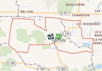
10,4 km | 11,9 km-effort
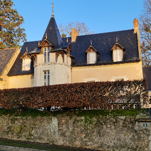
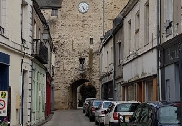
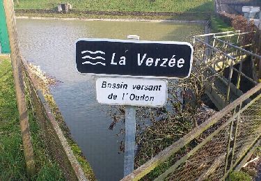
3h 40min
![](https://static1.geolcdn.com/siteimages/upload/files/16400158638029165_repeat_loop_refresh_sync_direction_icon.png)
Sí
![Excursión Senderismo Ombrée-d'Anjou - pouancé - Photo](https://media.geolcdn.com/t/375/260/ext.jpg?maxdim=2&url=https%3A%2F%2Fservices.sitytrail.com%2FGeolivesWS%2FDownloadMedia.ashx%3FTrailID%3D177824%26Media%3D20130303162448.jpeg)
![Senderismo Senderismo](https://static1.geolcdn.com/sitytour/trail-icons/101.png)
pouancé
Senderismo
Muy fácil
Ombrée-d'Anjou,
Países del Loira,
Maine-y-Loira,
France
![](/images/other/stat-length.png)
2,7 km | 2,9 km-effort
42min
![](https://static1.geolcdn.com/siteimages/upload/files/16400158638029165_repeat_loop_refresh_sync_direction_icon.png)
Sí
![Excursión Senderismo Ombrée-d'Anjou - Petit tour des 7 clochers - Photo](https://media.geolcdn.com/t/375/260/ext.jpg?maxdim=2&url=https%3A%2F%2Fstatic1.geolcdn.com%2Fsiteimages%2Fupload%2Ffiles%2F1553511878bg_sport_marche.png)
![Senderismo Senderismo](https://static1.geolcdn.com/sitytour/trail-icons/101.png)
Petit tour des 7 clochers
Senderismo
Fácil
Ombrée-d'Anjou,
Países del Loira,
Maine-y-Loira,
France
![](/images/other/stat-length.png)
11 km | 12,3 km-effort
2h 28min
![](https://static1.geolcdn.com/siteimages/upload/files/16400158638029165_repeat_loop_refresh_sync_direction_icon.png)
Sí
![Excursión Senderismo Ombrée-d'Anjou - Petit tour des 7 clochers - Photo](https://media.geolcdn.com/t/375/260/ext.jpg?maxdim=2&url=https%3A%2F%2Fstatic1.geolcdn.com%2Fsiteimages%2Fupload%2Ffiles%2F1553511878bg_sport_marche.png)
![Senderismo Senderismo](https://static1.geolcdn.com/sitytour/trail-icons/101.png)
Petit tour des 7 clochers
Senderismo
Difícil
Ombrée-d'Anjou,
Países del Loira,
Maine-y-Loira,
France
![](/images/other/stat-length.png)
10,9 km | 12,3 km-effort
2h 47min
![](https://static1.geolcdn.com/siteimages/upload/files/16400158638029165_repeat_loop_refresh_sync_direction_icon.png)
Sí
![Excursión Senderismo Carbay - Carbay - Photo](https://media.geolcdn.com/t/375/260/ext.jpg?maxdim=2&url=https%3A%2F%2Fstatic1.geolcdn.com%2Fsiteimages%2Fupload%2Ffiles%2F1553511878bg_sport_marche.png)
![Senderismo Senderismo](https://static1.geolcdn.com/sitytour/trail-icons/101.png)
Carbay
Senderismo
Fácil
Carbay,
Países del Loira,
Maine-y-Loira,
France
![](/images/other/stat-length.png)
11,3 km | 12,5 km-effort
2h 50min
![](https://static1.geolcdn.com/siteimages/upload/files/16400158638029165_repeat_loop_refresh_sync_direction_icon.png)
Sí
![Excursión Senderismo Ombrée-d'Anjou - Sentier des 7 clochers à Pouancé
- Photo](https://media.geolcdn.com/t/375/260/ext.jpg?maxdim=2&url=https%3A%2F%2Fstatic1.geolcdn.com%2Fsiteimages%2Fupload%2Ffiles%2F1553511878bg_sport_marche.png)
![Senderismo Senderismo](https://static1.geolcdn.com/sitytour/trail-icons/101.png)
Sentier des 7 clochers à Pouancé
Senderismo
Fácil
Ombrée-d'Anjou,
Países del Loira,
Maine-y-Loira,
France
![](/images/other/stat-length.png)
13,6 km | 15,2 km-effort
3h 27min
![](https://static1.geolcdn.com/siteimages/upload/files/16400158638029165_repeat_loop_refresh_sync_direction_icon.png)
Sí
![Excursión Senderismo Ombrée-d'Anjou - Pouancé-Armaillé - Photo](https://media.geolcdn.com/t/375/260/ext.jpg?maxdim=2&url=https%3A%2F%2Fstatic1.geolcdn.com%2Fsiteimages%2Fupload%2Ffiles%2F1553511878bg_sport_marche.png)
![Senderismo Senderismo](https://static1.geolcdn.com/sitytour/trail-icons/101.png)
Pouancé-Armaillé
Senderismo
Fácil
Ombrée-d'Anjou,
Países del Loira,
Maine-y-Loira,
France
![](/images/other/stat-length.png)
20 km | 23 km-effort
5h 9min
![](https://static1.geolcdn.com/siteimages/upload/files/16400158638029165_repeat_loop_refresh_sync_direction_icon.png)
Sí
![Excursión sport Ombrée-d'Anjou - FR49.Armaillé, boucle Jacquaire - Photo](https://media.geolcdn.com/t/375/260/ext.jpg?maxdim=2&url=https%3A%2F%2Fsecurestorage.geolives.com%2Fsitytour%2Ftrail-bg%2Fdefault.jpg)
FR49.Armaillé, boucle Jacquaire
sport
Muy fácil
Ombrée-d'Anjou,
Países del Loira,
Maine-y-Loira,
France
![](/images/other/stat-length.png)
13,6 km | 15,3 km-effort
Desconocido
![](https://static1.geolcdn.com/siteimages/upload/files/16400158638029165_repeat_loop_refresh_sync_direction_icon.png)
Sí
![Excursión sport Ombrée-d'Anjou - FR49.Carbay, sentier du Roy + étangs - Photo](https://media.geolcdn.com/t/375/260/ext.jpg?maxdim=2&url=https%3A%2F%2Fsecurestorage.geolives.com%2Fsitytour%2Ftrail-bg%2Fdefault.jpg)
FR49.Carbay, sentier du Roy + étangs
sport
Muy fácil
Ombrée-d'Anjou,
Países del Loira,
Maine-y-Loira,
France
![](/images/other/stat-length.png)
22 km | 26 km-effort
Desconocido
![](https://static1.geolcdn.com/siteimages/upload/files/16400158638029165_repeat_loop_refresh_sync_direction_icon.png)
Sí