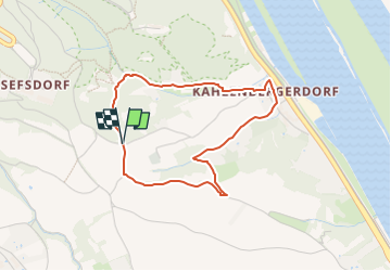
![](/images/other/stat-length.png)
![Excursión A pie Desconocido - Kahlenbergerdorfer Weinrundwanderweg - Photo](https://media.geolcdn.com/t/1900/400/e218559e-5d8c-463c-80d9-0b8152eec5ac.jpeg&format=pjpeg&maxdim=2)
Kahlenbergerdorfer Weinrundwanderweg
SityTrail - itinéraires balisés pédestres
Tous les sentiers balisés d’Europe GUIDE+
![Longitud](/images/other/stat-length.png)
![Altitud máxima](https://static1.geolcdn.com/siteimages/upload/files/1508320355ic_sort_altitude_max_24dp.png)
![Desnivel positivo](https://static1.geolcdn.com/siteimages/upload/files/1508320355ic_sort_den_pos_24dp.png)
![Km-Effort](/images/other/stat-length.png)
![Altitud mínima](https://static1.geolcdn.com/siteimages/upload/files/1508320355ic_sort_altitude_min_24dp.png)
![Desnivel negativo](https://static1.geolcdn.com/siteimages/upload/files/1508320355ic_sort_den_neg_24dp.png)
![Boucle](https://static1.geolcdn.com/siteimages/upload/files/16400158638029165_repeat_loop_refresh_sync_direction_icon.png)
![A pie](https://static1.geolcdn.com/sitytour/trail-icons/100.png)
1h14
Dificultad : Fácil
![Escanee este código QR para abrir la excursión en la aplicación SityTrail](https://capi.geolives.com/qq0zvz2zws4bq2lad0pu/sitytour/trails/3127509/qr.png?size=200)
Aplicación GPS de excursión GRATIS
A propósito
Ruta A pie de 3,3 km a descubrir en Viena, Desconocido, Desconocido. Esta ruta ha sido propuesta por SityTrail - itinéraires balisés pédestres.
Descripción
Trail created by ÖTK-Klosterneuburg; Freunde des Kahlenbergerdorfes.
another website: http://www.kahlenbergerdorf.at/Weinrundwanderweg.htm
Symbol: weiss-gruen-weiss
Sitio web: https://www.oetk-klosterneuburg.at/index.php/unsere-wege/weginformation/410-kahlenbergerdorf-kahlenbergerdorf
Localización
Comentarios
Excursiones cerca
![Excursión A pie Gemeinde Klosterneuburg - Weidling - Kierling (Dr. Walter Brandstetter Weg) - Photo](https://media.geolcdn.com/t/375/260/4443d887-bb67-409e-9884-c1e7d6cd8438.jpeg&format=jpg&maxdim=2)
![A pie A pie](https://static1.geolcdn.com/sitytour/trail-icons/100.png)
A pie
![](/images/other/stat-length.png)
![](https://static1.geolcdn.com/siteimages/upload/files/16400158638029165_repeat_loop_refresh_sync_direction_icon.png)
![Excursión A pie Gemeinde Klosterneuburg - Weidling - Hohenauer Wiese - Photo](https://media.geolcdn.com/t/375/260/a3fef88e-6ffd-425c-81bc-63c3658ae9d6.jpeg&format=jpg&maxdim=2)
![A pie A pie](https://static1.geolcdn.com/sitytour/trail-icons/100.png)
A pie
![](/images/other/stat-length.png)
![](https://static1.geolcdn.com/siteimages/upload/files/16400158638029165_repeat_loop_refresh_sync_direction_icon.png)
![Excursión A pie Desconocido - Grüß di a Gott Wirt - Cobenzl - Photo](https://media.geolcdn.com/t/375/260/0343ff54-7543-4905-afff-c2d6aabb810a.jpeg&format=jpg&maxdim=2)
![A pie A pie](https://static1.geolcdn.com/sitytour/trail-icons/100.png)
A pie
![](/images/other/stat-length.png)
![](https://static1.geolcdn.com/siteimages/upload/files/16400158638029165_repeat_loop_refresh_sync_direction_icon.png)
![Excursión A pie Desconocido - Sievering/Gspöttgraben - Habsburgwarte - Photo](https://media.geolcdn.com/t/375/260/a0373cb7-e5a7-4848-9c81-91f4b5c5255d.jpeg&format=jpg&maxdim=2)
![A pie A pie](https://static1.geolcdn.com/sitytour/trail-icons/100.png)
A pie
![](/images/other/stat-length.png)
![](https://static1.geolcdn.com/siteimages/upload/files/16400158638029165_repeat_loop_refresh_sync_direction_icon.png)
![Excursión A pie Gemeinde Klosterneuburg - Klosterneuburg - Hinterweidling - Photo](https://media.geolcdn.com/t/375/260/f829833b-6801-4cba-96fc-04e334598f2f.jpeg&format=jpg&maxdim=2)
![A pie A pie](https://static1.geolcdn.com/sitytour/trail-icons/100.png)
A pie
![](/images/other/stat-length.png)
![](https://static1.geolcdn.com/siteimages/upload/files/16400158638029165_repeat_loop_refresh_sync_direction_icon.png)
![Excursión A pie Desconocido - Kahlenberg - Jägerwiese - Photo](https://media.geolcdn.com/t/375/260/65cfa7de-403f-4e92-a9d6-2de65948c5dc.jpeg&format=jpg&maxdim=2)
![A pie A pie](https://static1.geolcdn.com/sitytour/trail-icons/100.png)
A pie
![](/images/other/stat-length.png)
![](https://static1.geolcdn.com/siteimages/upload/files/16400158638029165_repeat_loop_refresh_sync_direction_icon.png)
![Excursión A pie Desconocido - Stadtwanderweg 12 - West-Ost - Photo](https://media.geolcdn.com/t/375/260/25d66604-db3d-404f-b3be-67ff4aeb2cea.jpeg&format=jpg&maxdim=2)
![A pie A pie](https://static1.geolcdn.com/sitytour/trail-icons/100.png)
A pie
![](/images/other/stat-length.png)
![](https://static1.geolcdn.com/siteimages/upload/files/16400158638029165_repeat_loop_refresh_sync_direction_icon.png)
![Excursión A pie Desconocido - Stadtwanderweg 1a - Leopoldsberg - Photo](https://media.geolcdn.com/t/375/260/9d3a3215-fcd1-4305-ae3d-c5ce3048d857.jpeg&format=jpg&maxdim=2)
![A pie A pie](https://static1.geolcdn.com/sitytour/trail-icons/100.png)
A pie
![](/images/other/stat-length.png)
![](https://static1.geolcdn.com/siteimages/upload/files/16400158638029165_repeat_loop_refresh_sync_direction_icon.png)
![Excursión A pie Gemeinde Klosterneuburg - Bhf. Klosterneuburg Kierling-Hadersfeld - Photo](https://media.geolcdn.com/t/375/260/2d07c5fe-d96b-4089-a6dc-d48db6ef341d.jpeg&format=jpg&maxdim=2)
![A pie A pie](https://static1.geolcdn.com/sitytour/trail-icons/100.png)
A pie
![](/images/other/stat-length.png)
![](https://static1.geolcdn.com/siteimages/upload/files/16400158638029165_repeat_loop_refresh_sync_direction_icon.png)