![](/images/other/stat-length.png)
![Excursión A pie Fiesole - IT-10 - Photo](https://media.geolcdn.com/t/1900/400/ext.pjpeg?maxdim=2&url=https%3A%2F%2Fmedia.geolcdn.com%2Ff%2F99aea3c1-938d-4da7-9462-71c60e7d601e.jpeg)
IT-10
SityTrail - itinéraires balisés pédestres
Tous les sentiers balisés d’Europe PRO
![Longitud](/images/other/stat-length.png)
Longitud
9,9 km
![Altitud máxima](https://static1.geolcdn.com/siteimages/upload/files/1508320355ic_sort_altitude_max_24dp.png)
Altitud máxima
461 m
![Desnivel positivo](https://static1.geolcdn.com/siteimages/upload/files/1508320355ic_sort_den_pos_24dp.png)
Desnivel positivo
402 m
![Km-Effort](/images/other/stat-length.png)
Km-Effort
14,7 km
![Altitud mínima](https://static1.geolcdn.com/siteimages/upload/files/1508320355ic_sort_altitude_min_24dp.png)
Altitud mínima
240 m
![Desnivel negativo](https://static1.geolcdn.com/siteimages/upload/files/1508320355ic_sort_den_neg_24dp.png)
Desnivel negativo
249 m
![Boucle](https://static1.geolcdn.com/siteimages/upload/files/16400158638029165_repeat_loop_refresh_sync_direction_icon.png)
Boucle
No
Baliza
Fecha de creación :
2022-02-15 19:27:56.081
Última modificación :
2022-03-01 23:56:05.641
![A pie](https://static1.geolcdn.com/sitytour/trail-icons/100.png)
3h20
Dificultad : Fácil
![Escanee este código QR para abrir la excursión en la aplicación SityTrail](https://capi.geolives.com/qq0zvz2zws4bq2lad0pu/sitytour/trails/3124743/qr.png?size=200)
Aplicación GPS de excursión GRATIS
A propósito
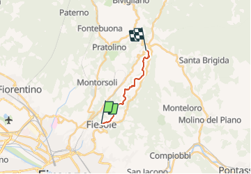
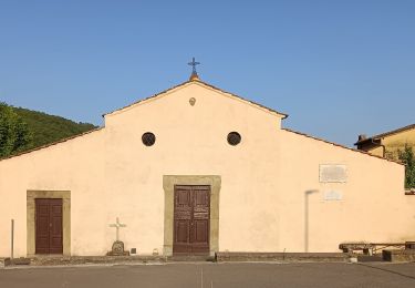
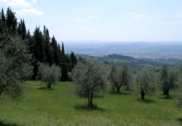
Ruta A pie de 9,9 km a descubrir en Toscana, Ciudad Metropolitana de Florencia, Fiesole. Esta ruta ha sido propuesta por SityTrail - itinéraires balisés pédestres.
Descripción
Trail created by Club Alpino Italiano.
Localización
País:
Italy
Región :
Toscana
Departamento/provincia :
Ciudad Metropolitana de Florencia
Municipio :
Fiesole
Localidad:
Unknown
Salida:(Dec)
Salida:(UTM)
684432 ; 4853013 (32T) N.
Comentarios
Excursiones cerca
![Excursión A pie Fiesole - IT-60 - Photo](https://media.geolcdn.com/t/375/260/ext.jpg?maxdim=2&url=https%3A%2F%2Fmedia.geolcdn.com%2Ff%2F4ae73887-f3a4-47b3-a505-8bc06e1d2895.jpeg)
![A pie A pie](https://static1.geolcdn.com/sitytour/trail-icons/100.png)
IT-60
A pie
Difícil
Fiesole,
Toscana,
Ciudad Metropolitana de Florencia,
Italy
![](/images/other/stat-length.png)
22 km | 33 km-effort
7h 27min
![](https://static1.geolcdn.com/siteimages/upload/files/16400158638029165_repeat_loop_refresh_sync_direction_icon.png)
No
![Excursión A pie Florencia - IT-7 - Photo](https://media.geolcdn.com/t/375/260/ext.jpg?maxdim=2&url=https%3A%2F%2Fmedia.geolcdn.com%2Ff%2F14b655a7-5816-4582-9aed-163653c7ea01.jpeg)
![A pie A pie](https://static1.geolcdn.com/sitytour/trail-icons/100.png)
IT-7
A pie
Fácil
Florencia,
Toscana,
Ciudad Metropolitana de Florencia,
Italy
![](/images/other/stat-length.png)
4,1 km | 7,5 km-effort
1h 42min
![](https://static1.geolcdn.com/siteimages/upload/files/16400158638029165_repeat_loop_refresh_sync_direction_icon.png)
No
![Excursión A pie Fiesole - Sentiero delle Testimonianze - Photo](https://media.geolcdn.com/t/375/260/ext.jpg?maxdim=2&url=https%3A%2F%2Fmedia.geolcdn.com%2Ff%2F704f47ef-eed8-4e9c-a2bb-3431d1f1f40d.jpeg)
![A pie A pie](https://static1.geolcdn.com/sitytour/trail-icons/100.png)
Sentiero delle Testimonianze
A pie
Medio
Fiesole,
Toscana,
Ciudad Metropolitana de Florencia,
Italy
![](/images/other/stat-length.png)
16,4 km | 25 km-effort
5h 45min
![](https://static1.geolcdn.com/siteimages/upload/files/16400158638029165_repeat_loop_refresh_sync_direction_icon.png)
No
![Excursión A pie Sesto Fiorentino - Sentiero CAI 2C - Sez. Sesto Fiorentino - Photo](https://media.geolcdn.com/t/375/260/ext.jpg?maxdim=2&url=https%3A%2F%2Fmedia.geolcdn.com%2Ff%2Fdc95924d-6a01-400b-ad20-1d3d94b9f4c7.jpeg)
![A pie A pie](https://static1.geolcdn.com/sitytour/trail-icons/100.png)
Sentiero CAI 2C - Sez. Sesto Fiorentino
A pie
Fácil
Sesto Fiorentino,
Toscana,
Ciudad Metropolitana de Florencia,
Italy
![](/images/other/stat-length.png)
4,2 km | 5,8 km-effort
1h 19min
![](https://static1.geolcdn.com/siteimages/upload/files/16400158638029165_repeat_loop_refresh_sync_direction_icon.png)
No
![Excursión A pie Fiesole - IT-IF4 - Photo](https://media.geolcdn.com/t/375/260/ext.jpg?maxdim=2&url=https%3A%2F%2Fmedia.geolcdn.com%2Ff%2F577e33c6-2cd4-4a91-b7a5-a206ea0026db.jpeg)
![A pie A pie](https://static1.geolcdn.com/sitytour/trail-icons/100.png)
IT-IF4
A pie
Fácil
Fiesole,
Toscana,
Ciudad Metropolitana de Florencia,
Italy
![](/images/other/stat-length.png)
12,7 km | 19,7 km-effort
4h 28min
![](https://static1.geolcdn.com/siteimages/upload/files/16400158638029165_repeat_loop_refresh_sync_direction_icon.png)
No
![Excursión A pie Fiesole - IT-IF1 - Photo](https://media.geolcdn.com/t/375/260/ext.jpg?maxdim=2&url=https%3A%2F%2Fmedia.geolcdn.com%2Ff%2Fd7d9fce1-38bf-442c-b99c-0a8ce56334e1.jpeg)
![A pie A pie](https://static1.geolcdn.com/sitytour/trail-icons/100.png)
IT-IF1
A pie
Fácil
Fiesole,
Toscana,
Ciudad Metropolitana de Florencia,
Italy
![](/images/other/stat-length.png)
13,4 km | 19,3 km-effort
4h 23min
![](https://static1.geolcdn.com/siteimages/upload/files/16400158638029165_repeat_loop_refresh_sync_direction_icon.png)
Sí
![Excursión A pie Fiesole - Sentiero CAI 6 - Sez. Firenze - Photo](https://media.geolcdn.com/t/375/260/ext.jpg?maxdim=2&url=https%3A%2F%2Fmedia.geolcdn.com%2Ff%2Fec0ccdd2-0502-4e24-8318-e68c10d5f003.jpeg)
![A pie A pie](https://static1.geolcdn.com/sitytour/trail-icons/100.png)
Sentiero CAI 6 - Sez. Firenze
A pie
Fácil
Fiesole,
Toscana,
Ciudad Metropolitana de Florencia,
Italy
![](/images/other/stat-length.png)
5 km | 8,6 km-effort
1h 57min
![](https://static1.geolcdn.com/siteimages/upload/files/16400158638029165_repeat_loop_refresh_sync_direction_icon.png)
No
![Excursión A pie Fiesole - Sentiero CAI 8 - Sez. Firenze - Photo](https://media.geolcdn.com/t/375/260/ext.jpg?maxdim=2&url=https%3A%2F%2Fmedia.geolcdn.com%2Ff%2Fec0ccdd2-0502-4e24-8318-e68c10d5f003.jpeg)
![A pie A pie](https://static1.geolcdn.com/sitytour/trail-icons/100.png)
Sentiero CAI 8 - Sez. Firenze
A pie
Fácil
Fiesole,
Toscana,
Ciudad Metropolitana de Florencia,
Italy
![](/images/other/stat-length.png)
3,7 km | 6,9 km-effort
1h 34min
![](https://static1.geolcdn.com/siteimages/upload/files/16400158638029165_repeat_loop_refresh_sync_direction_icon.png)
No
![Excursión A pie Florencia - IT-2 - Photo](https://media.geolcdn.com/t/375/260/ext.jpg?maxdim=2&url=https%3A%2F%2Fmedia.geolcdn.com%2Ff%2Fb804a3fd-92ed-4aa6-9f68-693fcb4ef970.jpeg)
![A pie A pie](https://static1.geolcdn.com/sitytour/trail-icons/100.png)
IT-2
A pie
Fácil
Florencia,
Toscana,
Ciudad Metropolitana de Florencia,
Italy
![](/images/other/stat-length.png)
12 km | 19,6 km-effort
4h 27min
![](https://static1.geolcdn.com/siteimages/upload/files/16400158638029165_repeat_loop_refresh_sync_direction_icon.png)
No