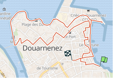
![](/images/other/stat-length.png)
![Excursión A pie Douarnenez - Le chemin de la sardine - Photo](https://media.geolcdn.com/t/1900/400/9ce746a4-512e-4653-b738-0ff8fd3fd82c.jpeg&format=pjpeg&maxdim=2)
Le chemin de la sardine
SityTrail - itinéraires balisés pédestres
Tous les sentiers balisés d’Europe GUIDE+
![Longitud](/images/other/stat-length.png)
![Altitud máxima](https://static1.geolcdn.com/siteimages/upload/files/1508320355ic_sort_altitude_max_24dp.png)
![Desnivel positivo](https://static1.geolcdn.com/siteimages/upload/files/1508320355ic_sort_den_pos_24dp.png)
![Km-Effort](/images/other/stat-length.png)
![Altitud mínima](https://static1.geolcdn.com/siteimages/upload/files/1508320355ic_sort_altitude_min_24dp.png)
![Desnivel negativo](https://static1.geolcdn.com/siteimages/upload/files/1508320355ic_sort_den_neg_24dp.png)
![Boucle](https://static1.geolcdn.com/siteimages/upload/files/16400158638029165_repeat_loop_refresh_sync_direction_icon.png)
![A pie](https://static1.geolcdn.com/sitytour/trail-icons/100.png)
1h08
Dificultad : Fácil
![Escanee este código QR para abrir la excursión en la aplicación SityTrail](https://capi.geolives.com/qq0zvz2zws4bq2lad0pu/sitytour/trails/3124514/qr.png?size=200)
Aplicación GPS de excursión GRATIS
A propósito
Ruta A pie de 4,1 km a descubrir en Bretaña, Finisterre, Douarnenez. Esta ruta ha sido propuesta por SityTrail - itinéraires balisés pédestres.
Descripción
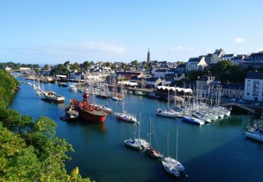
Ce circuit vous explique l'Histoire sardinière de la ville depuis l'époque Gallo-romaine jusqu'aux dernières mutations du port de Douarnenez. Des clous en bronze donnent la direction de 17 pupitres explicatifs illustrés par d'anciennes photos de la ville. Le circuit débute sur le belvédère des Plomarc'h, surplombant la baie et le port et propose une promenade dans la ville qui vous mènera du port du Rosmeur avec ses venelles et façades colorées, au Port Rhu, et au front de mer face à l'île Tristan. N'hésitez pas à venir chercher le feuillet du chemin de la sardine à l'Office de Tourisme. Durée : 2h00 Niveau de difficulté : facile. À certains passages, des escaliers. Retrouvez cet itinéraire dans le topo-guide L'Ouest Cornouaille ... à pied Le Pays de Douarnenez, le Cap Sizun et le Pays Bigouden. En vente en librairie, dans les offices de tourisme en Bretagne et sur https://bretagne.ffrandonnee.fr/topo/
Sitio web: https://www.tourismebretagne.com/offres/le-chemin-de-la-sardine-douarnenez-fr-2395085/
Localización
Comentarios
Excursiones cerca
![Excursión Senderismo Douarnenez - Douarnenez - GR34 AR les Roches Blanches Pointe de la Jument - 9.3km 250m 3h30 - 2019 09 01 - Photo](https://media.geolcdn.com/t/375/260/ab448e69-f6b6-4c7f-80fa-8b9533bb0920.jpg&format=jpg&maxdim=2)
![Senderismo Senderismo](https://static1.geolcdn.com/sitytour/trail-icons/101.png)
Senderismo
![](/images/other/stat-length.png)
![](https://static1.geolcdn.com/siteimages/upload/files/16400158638029165_repeat_loop_refresh_sync_direction_icon.png)
![Excursión Senderismo Douarnenez - TREK RCY GR34 2022 j2 Douarnenez- Beuzec - Photo](https://media.geolcdn.com/t/375/260/8fdd798e-9630-4ffb-bea5-9ee3ec61b3a8.jpg&format=jpg&maxdim=2)
![Senderismo Senderismo](https://static1.geolcdn.com/sitytour/trail-icons/101.png)
Senderismo
![](/images/other/stat-length.png)
![](https://static1.geolcdn.com/siteimages/upload/files/16400158638029165_repeat_loop_refresh_sync_direction_icon.png)
![Excursión Senderismo Douarnenez - Trek RCY GR 34 2022- journée 1 Balade Douarnenez - Photo](https://media.geolcdn.com/t/375/260/e6241847-f9f8-4845-8061-377f37ea1e75.jpg&format=jpg&maxdim=2)
![Senderismo Senderismo](https://static1.geolcdn.com/sitytour/trail-icons/101.png)
Senderismo
![](/images/other/stat-length.png)
![](https://static1.geolcdn.com/siteimages/upload/files/16400158638029165_repeat_loop_refresh_sync_direction_icon.png)
![Excursión Senderismo Douarnenez - Douarnenez - GR34 du port de plaisance aux Roches Blanches - 9.7km 165m 2h30 - 2019 09 06 - Photo](https://media.geolcdn.com/t/375/260/d1eb9c88-a75c-496a-a8ef-0db250d9eb67.jpg&format=jpg&maxdim=2)
![Senderismo Senderismo](https://static1.geolcdn.com/sitytour/trail-icons/101.png)
Senderismo
![](/images/other/stat-length.png)
![](https://static1.geolcdn.com/siteimages/upload/files/16400158638029165_repeat_loop_refresh_sync_direction_icon.png)
![Excursión Senderismo Douarnenez - Douarnenez - du Port Rhu - 5.8km 115m 1h45 - 2019 09 01 - Photo](https://media.geolcdn.com/t/375/260/28ac96a0-9369-40eb-a4d8-7b2ede676873.jpg&format=jpg&maxdim=2)
![Senderismo Senderismo](https://static1.geolcdn.com/sitytour/trail-icons/101.png)
Senderismo
![](/images/other/stat-length.png)
![](https://static1.geolcdn.com/siteimages/upload/files/16400158638029165_repeat_loop_refresh_sync_direction_icon.png)
![Excursión Senderismo Douarnenez - GR34 Douarnenez-- Pors Peron - Photo](https://media.geolcdn.com/t/375/260/55c8cb23-826e-4476-a89b-d5fdee2975ce.jpg&format=jpg&maxdim=2)
![Senderismo Senderismo](https://static1.geolcdn.com/sitytour/trail-icons/101.png)
Senderismo
![](/images/other/stat-length.png)
![](https://static1.geolcdn.com/siteimages/upload/files/16400158638029165_repeat_loop_refresh_sync_direction_icon.png)
![Excursión Senderismo Douarnenez - DOUARNENEZ - Photo](https://media.geolcdn.com/t/375/260/669ff4fd-0def-4571-a23c-23ec26be7050.jpg&format=jpg&maxdim=2)
![Senderismo Senderismo](https://static1.geolcdn.com/sitytour/trail-icons/101.png)
Senderismo
![](/images/other/stat-length.png)
![](https://static1.geolcdn.com/siteimages/upload/files/16400158638029165_repeat_loop_refresh_sync_direction_icon.png)
![Excursión Senderismo Douarnenez - TREK RCY GR34 2022 J1 Balade du soir - Photo](https://media.geolcdn.com/t/375/260/6afdc80c-f966-4c00-935f-4079c9c4567d.jpg&format=jpg&maxdim=2)
![Senderismo Senderismo](https://static1.geolcdn.com/sitytour/trail-icons/101.png)
Senderismo
![](/images/other/stat-length.png)
![](https://static1.geolcdn.com/siteimages/upload/files/16400158638029165_repeat_loop_refresh_sync_direction_icon.png)
![Excursión Senderismo Plonévez-Porzay - DOUARNENEZ - Photo](https://media.geolcdn.com/t/375/260/1d24512c-d956-41ff-85d7-ce007d0561fd.jpg&format=jpg&maxdim=2)
![Senderismo Senderismo](https://static1.geolcdn.com/sitytour/trail-icons/101.png)
Senderismo
![](/images/other/stat-length.png)
![](https://static1.geolcdn.com/siteimages/upload/files/16400158638029165_repeat_loop_refresh_sync_direction_icon.png)