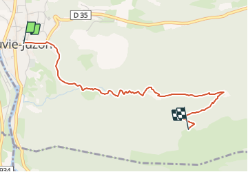
![](/images/other/stat-length.png)
![Excursión A pie Louvie-Juzon - Le piémont du Rey - Photo](https://media.geolcdn.com/t/1900/400/f491a556-8ecd-4525-a2fc-b2b6d591e533.jpeg&format=pjpeg&maxdim=2)
Le piémont du Rey
SityTrail - itinéraires balisés pédestres
Tous les sentiers balisés d’Europe GUIDE+
![Longitud](/images/other/stat-length.png)
![Altitud máxima](https://static1.geolcdn.com/siteimages/upload/files/1508320355ic_sort_altitude_max_24dp.png)
![Desnivel positivo](https://static1.geolcdn.com/siteimages/upload/files/1508320355ic_sort_den_pos_24dp.png)
![Km-Effort](/images/other/stat-length.png)
![Altitud mínima](https://static1.geolcdn.com/siteimages/upload/files/1508320355ic_sort_altitude_min_24dp.png)
![Desnivel negativo](https://static1.geolcdn.com/siteimages/upload/files/1508320355ic_sort_den_neg_24dp.png)
![Boucle](https://static1.geolcdn.com/siteimages/upload/files/16400158638029165_repeat_loop_refresh_sync_direction_icon.png)
![A pie](https://static1.geolcdn.com/sitytour/trail-icons/100.png)
2h19
Dificultad : Fácil
![Escanee este código QR para abrir la excursión en la aplicación SityTrail](https://capi.geolives.com/qq0zvz2zws4bq2lad0pu/sitytour/trails/3123577/qr.png?size=200)
Aplicación GPS de excursión GRATIS
A propósito
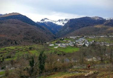
Ruta A pie de 3,5 km a descubrir en Nueva Aquitania, Pirineos-Atlánticos, Louvie-Juzon. Esta ruta ha sido propuesta por SityTrail - itinéraires balisés pédestres.
Descripción
Trail created by Communauté de Communes de la Vallée d’Ossau.
Sitio web: https://www.valleedossau-tourisme.com/randonnees/pedestre/circuits-a-la-journee/
Localización
Comentarios
Excursiones cerca
![Excursión Senderismo Louvie-Juzon - Soum de las Picarras Montagne du Rey - Photo](https://media.geolcdn.com/t/375/260/ext.jpg?maxdim=2&url=https%3A%2F%2Fservices.sitytrail.com%2FGeolivesWS%2FDownloadMedia.ashx%3FTrailID%3D541294%26Media%3Dfix__20160320134039.jpg)
![Senderismo Senderismo](https://static1.geolcdn.com/sitytour/trail-icons/101.png)
Senderismo
![](/images/other/stat-length.png)
![](https://static1.geolcdn.com/siteimages/upload/files/16400158638029165_repeat_loop_refresh_sync_direction_icon.png)
![Excursión Senderismo Bielle - BIELLE l arriu Mage reco 3443541 - Photo](https://media.geolcdn.com/t/375/260/85ef7966-54fd-44d2-aeee-6b5bc4ac7165.jpg&format=jpg&maxdim=2)
![Senderismo Senderismo](https://static1.geolcdn.com/sitytour/trail-icons/101.png)
Senderismo
![](/images/other/stat-length.png)
![](https://static1.geolcdn.com/siteimages/upload/files/16400158638029165_repeat_loop_refresh_sync_direction_icon.png)
![Excursión A pie Bielle - L'Arriu-Mage - Photo](https://media.geolcdn.com/t/375/260/9d640f1d-cca3-4d6c-b124-0b8f06a68e5a.jpeg&format=jpg&maxdim=2)
![A pie A pie](https://static1.geolcdn.com/sitytour/trail-icons/100.png)
A pie
![](/images/other/stat-length.png)
![](https://static1.geolcdn.com/siteimages/upload/files/16400158638029165_repeat_loop_refresh_sync_direction_icon.png)
![Excursión A pie Bilhères - Les cercles de pierre (Bilhères) - Photo](https://media.geolcdn.com/t/375/260/d1f3f786-1fe8-47a8-af2d-8ff90104ea03.jpeg&format=jpg&maxdim=2)
![A pie A pie](https://static1.geolcdn.com/sitytour/trail-icons/100.png)
A pie
![](/images/other/stat-length.png)
![](https://static1.geolcdn.com/siteimages/upload/files/16400158638029165_repeat_loop_refresh_sync_direction_icon.png)
![Excursión A pie Bilhères - Les cabanes de Lasbordes - Photo](https://media.geolcdn.com/t/375/260/6d402dc4-6faf-449a-b98e-9a6932ddd2f6.jpeg&format=jpg&maxdim=2)
![A pie A pie](https://static1.geolcdn.com/sitytour/trail-icons/100.png)
A pie
![](/images/other/stat-length.png)
![](https://static1.geolcdn.com/siteimages/upload/files/16400158638029165_repeat_loop_refresh_sync_direction_icon.png)
![Excursión A pie Arudy - Le tour du bassin d'Arudy - Photo](https://media.geolcdn.com/t/375/260/f77d5769-a1f2-499c-9920-96e8d227d4fb.jpeg&format=jpg&maxdim=2)
![A pie A pie](https://static1.geolcdn.com/sitytour/trail-icons/100.png)
A pie
![](/images/other/stat-length.png)
![](https://static1.geolcdn.com/siteimages/upload/files/16400158638029165_repeat_loop_refresh_sync_direction_icon.png)
![Excursión A pie Sainte-Colome - Les buis - Photo](https://media.geolcdn.com/t/375/260/4276e983-4156-4966-8238-f2764987fcc4.jpeg&format=jpg&maxdim=2)
![A pie A pie](https://static1.geolcdn.com/sitytour/trail-icons/100.png)
A pie
![](/images/other/stat-length.png)
![](https://static1.geolcdn.com/siteimages/upload/files/16400158638029165_repeat_loop_refresh_sync_direction_icon.png)
![Excursión A pie Bilhères - Le Turon de Técouère - Photo](https://media.geolcdn.com/t/375/260/b6cd5576-3b7b-4d3a-b695-7d81816e4fdf.jpeg&format=jpg&maxdim=2)
![A pie A pie](https://static1.geolcdn.com/sitytour/trail-icons/100.png)
A pie
![](/images/other/stat-length.png)
![](https://static1.geolcdn.com/siteimages/upload/files/16400158638029165_repeat_loop_refresh_sync_direction_icon.png)
![Excursión A pie Bilhères - Les cercles de pierre - Photo](https://media.geolcdn.com/t/375/260/3261c3d9-233f-4ca5-af9f-ab28710563bb.jpeg&format=jpg&maxdim=2)
![A pie A pie](https://static1.geolcdn.com/sitytour/trail-icons/100.png)
A pie
![](/images/other/stat-length.png)
![](https://static1.geolcdn.com/siteimages/upload/files/16400158638029165_repeat_loop_refresh_sync_direction_icon.png)