![](/images/other/stat-length.png)
![Excursión Bicicleta Mennetou-sur-Cher - Entre Berry et Sologne - Photo](https://media.geolcdn.com/t/1900/400/ext.pjpeg?maxdim=2&url=https%3A%2F%2Fservices.sitytrail.com%2FGeolivesWS%2FDownloadMedia.ashx%3FTrailID%3D311913%26Media%3D1bd949bd-e8b3-4f8c-9132-fb2566c803fb.jpg)
Entre Berry et Sologne
Solognesud
Usuario
![Longitud](/images/other/stat-length.png)
Longitud
23 km
![Altitud máxima](https://static1.geolcdn.com/siteimages/upload/files/1508320355ic_sort_altitude_max_24dp.png)
Altitud máxima
141 m
![Desnivel positivo](https://static1.geolcdn.com/siteimages/upload/files/1508320355ic_sort_den_pos_24dp.png)
Desnivel positivo
201 m
![Km-Effort](/images/other/stat-length.png)
Km-Effort
25 km
![Altitud mínima](https://static1.geolcdn.com/siteimages/upload/files/1508320355ic_sort_altitude_min_24dp.png)
Altitud mínima
81 m
![Desnivel negativo](https://static1.geolcdn.com/siteimages/upload/files/1508320355ic_sort_den_neg_24dp.png)
Desnivel negativo
205 m
![Boucle](https://static1.geolcdn.com/siteimages/upload/files/16400158638029165_repeat_loop_refresh_sync_direction_icon.png)
Boucle
Sí
Fecha de creación :
2014-12-10 00:00:00.0
Última modificación :
2014-12-10 00:00:00.0
![Bicicleta](https://static1.geolcdn.com/sitytour/trail-icons/200.png)
1h29
Dificultad : Fácil
![Escanee este código QR para abrir la excursión en la aplicación SityTrail](https://capi.geolives.com/qq0zvz2zws4bq2lad0pu/sitytour/trails/311913/qr.png?size=200)
Aplicación GPS de excursión GRATIS
A propósito
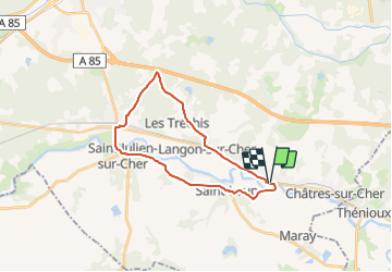
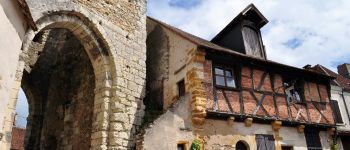
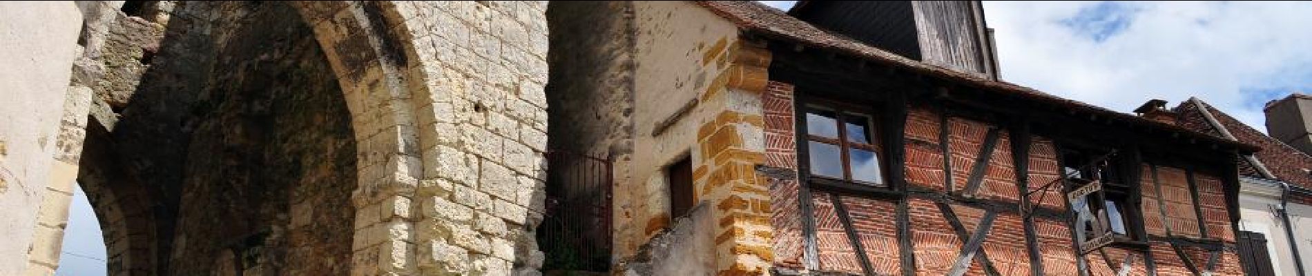
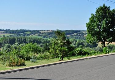
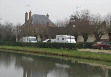
Ruta Bicicleta de 23 km a descubrir en Centro, Loir y Cher, Mennetou-sur-Cher. Esta ruta ha sido propuesta por Solognesud.
Descripción
Balade à vélo au départ de la Cité Médiévale de Mennetou sur Cher permettant la découverte des patrimoines bâtis, paysagers et vernaculaires de la Sologne, côté sud.
Puntos de interés
Localización
País:
France
Región :
Centro
Departamento/provincia :
Loir y Cher
Municipio :
Mennetou-sur-Cher
Localidad:
Unknown
Salida:(Dec)
Salida:(UTM)
414273 ; 5235725 (31T) N.
Comentarios
Excursiones cerca
![Excursión Senderismo Mennetou-sur-Cher - Entre forêt et manoirs, sur le chemin des Barres - Photo](https://media.geolcdn.com/t/375/260/ext.jpg?maxdim=2&url=https%3A%2F%2Fservices.sitytrail.com%2FGeolivesWS%2FDownloadMedia.ashx%3FTrailID%3D311844%26Media%3Ddfdba42c-5716-4a31-b350-44153d9e554b.jpg)
![Senderismo Senderismo](https://static1.geolcdn.com/sitytour/trail-icons/101.png)
Entre forêt et manoirs, sur le chemin des Barres
Senderismo
Fácil
(2)
Mennetou-sur-Cher,
Centro,
Loir y Cher,
France
![](/images/other/stat-length.png)
10,8 km | 12,1 km-effort
2h 42min
![](https://static1.geolcdn.com/siteimages/upload/files/16400158638029165_repeat_loop_refresh_sync_direction_icon.png)
Sí
![Excursión Senderismo Mennetou-sur-Cher - Chemin du Briou - Mennetou-sur-Cher - Photo](https://media.geolcdn.com/t/375/260/ext.jpg?maxdim=2&url=https%3A%2F%2Fservices.sitytrail.com%2FGeolivesWS%2FDownloadMedia.ashx%3FTrailID%3D105100%26Media%3D8694_6.jpg)
![Senderismo Senderismo](https://static1.geolcdn.com/sitytour/trail-icons/101.png)
Chemin du Briou - Mennetou-sur-Cher
Senderismo
Fácil
Mennetou-sur-Cher,
Centro,
Loir y Cher,
France
![](/images/other/stat-length.png)
7,7 km | 8,7 km-effort
2h 0min
![](https://static1.geolcdn.com/siteimages/upload/files/16400158638029165_repeat_loop_refresh_sync_direction_icon.png)
Sí
![Excursión Senderismo Mennetou-sur-Cher - MENNETOU - Photo](https://media.geolcdn.com/t/375/260/ext.jpg?maxdim=2&url=https%3A%2F%2Fservices.sitytrail.com%2FGeolivesWS%2FDownloadMedia.ashx%3FTrailID%3D253304%26Media%3De343b29e-f8c1-463c-8735-a50559882643.jpg)
![Senderismo Senderismo](https://static1.geolcdn.com/sitytour/trail-icons/101.png)
MENNETOU
Senderismo
Fácil
Mennetou-sur-Cher,
Centro,
Loir y Cher,
France
![](/images/other/stat-length.png)
12 km | 13,3 km-effort
2h 57min
![](https://static1.geolcdn.com/siteimages/upload/files/16400158638029165_repeat_loop_refresh_sync_direction_icon.png)
Sí
![Excursión Senderismo Mennetou-sur-Cher - mennetou sur cher - Photo](https://media.geolcdn.com/t/375/260/ext.jpg?maxdim=2&url=https%3A%2F%2Fstatic1.geolcdn.com%2Fsiteimages%2Fupload%2Ffiles%2F1553511878bg_sport_marche.png)
![Senderismo Senderismo](https://static1.geolcdn.com/sitytour/trail-icons/101.png)
mennetou sur cher
Senderismo
Fácil
Mennetou-sur-Cher,
Centro,
Loir y Cher,
France
![](/images/other/stat-length.png)
19,6 km | 22 km-effort
3h 9min
![](https://static1.geolcdn.com/siteimages/upload/files/16400158638029165_repeat_loop_refresh_sync_direction_icon.png)
Sí
![Excursión Senderismo Thénioux - thenioux - Photo](https://media.geolcdn.com/t/375/260/ext.jpg?maxdim=2&url=https%3A%2F%2Fstatic1.geolcdn.com%2Fsiteimages%2Fupload%2Ffiles%2F1553511878bg_sport_marche.png)
![Senderismo Senderismo](https://static1.geolcdn.com/sitytour/trail-icons/101.png)
![Excursión Senderismo Langon-sur-Cher - les etrils langon - Photo](https://media.geolcdn.com/t/375/260/ext.jpg?maxdim=2&url=https%3A%2F%2Fstatic1.geolcdn.com%2Fsiteimages%2Fupload%2Ffiles%2F1553511878bg_sport_marche.png)
![Senderismo Senderismo](https://static1.geolcdn.com/sitytour/trail-icons/101.png)
les etrils langon
Senderismo
Muy fácil
Langon-sur-Cher,
Centro,
Loir y Cher,
France
![](/images/other/stat-length.png)
14,3 km | 15,4 km-effort
2h 58min
![](https://static1.geolcdn.com/siteimages/upload/files/16400158638029165_repeat_loop_refresh_sync_direction_icon.png)
Sí
![Excursión Senderismo Châtres-sur-Cher - la chatre sur cher - Photo](https://media.geolcdn.com/t/375/260/ext.jpg?maxdim=2&url=https%3A%2F%2Fstatic1.geolcdn.com%2Fsiteimages%2Fupload%2Ffiles%2F1553511878bg_sport_marche.png)
![Senderismo Senderismo](https://static1.geolcdn.com/sitytour/trail-icons/101.png)
la chatre sur cher
Senderismo
Muy fácil
Châtres-sur-Cher,
Centro,
Loir y Cher,
France
![](/images/other/stat-length.png)
17,6 km | 19,4 km-effort
2h 42min
![](https://static1.geolcdn.com/siteimages/upload/files/16400158638029165_repeat_loop_refresh_sync_direction_icon.png)
Sí
![Excursión Senderismo Saint-Loup - rando saint loup - Photo](https://media.geolcdn.com/t/375/260/ext.jpg?maxdim=2&url=https%3A%2F%2Fstatic1.geolcdn.com%2Fsiteimages%2Fupload%2Ffiles%2F1553511878bg_sport_marche.png)
![Senderismo Senderismo](https://static1.geolcdn.com/sitytour/trail-icons/101.png)
rando saint loup
Senderismo
Muy fácil
Saint-Loup,
Centro,
Loir y Cher,
France
![](/images/other/stat-length.png)
12,3 km | 14 km-effort
2h 55min
![](https://static1.geolcdn.com/siteimages/upload/files/16400158638029165_repeat_loop_refresh_sync_direction_icon.png)
Sí
![Excursión Senderismo Mennetou-sur-Cher - mennetou sur cher - Photo](https://media.geolcdn.com/t/375/260/ext.jpg?maxdim=2&url=https%3A%2F%2Fstatic1.geolcdn.com%2Fsiteimages%2Fupload%2Ffiles%2F1553511878bg_sport_marche.png)
![Senderismo Senderismo](https://static1.geolcdn.com/sitytour/trail-icons/101.png)
mennetou sur cher
Senderismo
Fácil
Mennetou-sur-Cher,
Centro,
Loir y Cher,
France
![](/images/other/stat-length.png)
12,1 km | 13,2 km-effort
2h 40min
![](https://static1.geolcdn.com/siteimages/upload/files/16400158638029165_repeat_loop_refresh_sync_direction_icon.png)
Sí