![](/images/other/stat-length.png)
![Excursión A pie Sant Feliu de Guíxols - Sant Feliu de Guixols-Pedralta-Sant Benet - Photo](https://media.geolcdn.com/t/1900/400/ab799afa-e5ae-4f54-b104-e353e1c8128b.jpeg&format=pjpeg&maxdim=2)
Sant Feliu de Guixols-Pedralta-Sant Benet
SityTrail - itinéraires balisés pédestres
Tous les sentiers balisés d’Europe GUIDE+
![Longitud](/images/other/stat-length.png)
![Altitud máxima](https://static1.geolcdn.com/siteimages/upload/files/1508320355ic_sort_altitude_max_24dp.png)
![Desnivel positivo](https://static1.geolcdn.com/siteimages/upload/files/1508320355ic_sort_den_pos_24dp.png)
![Km-Effort](/images/other/stat-length.png)
![Altitud mínima](https://static1.geolcdn.com/siteimages/upload/files/1508320355ic_sort_altitude_min_24dp.png)
![Desnivel negativo](https://static1.geolcdn.com/siteimages/upload/files/1508320355ic_sort_den_neg_24dp.png)
![Boucle](https://static1.geolcdn.com/siteimages/upload/files/16400158638029165_repeat_loop_refresh_sync_direction_icon.png)
![A pie](https://static1.geolcdn.com/sitytour/trail-icons/100.png)
5h24
Dificultad : Medio
![Escanee este código QR para abrir la excursión en la aplicación SityTrail](https://capi.geolives.com/qq0zvz2zws4bq2lad0pu/sitytour/trails/3110637/qr.png?size=200)
Aplicación GPS de excursión GRATIS
A propósito
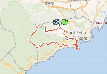
Ruta A pie de 17,1 km a descubrir en Cataluña, Gerona, Sant Feliu de Guíxols. Esta ruta ha sido propuesta por SityTrail - itinéraires balisés pédestres.
Descripción
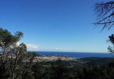
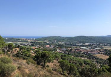
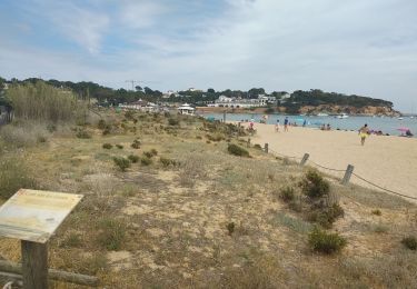
Breu introducció. Ruta circular pels voltants de Sant Feliu de Guíxols, que passa per l´ermita de Sant Amanç; pel paratge de Pedralta, amb el seu mirador, i finalment arriba a Sant Elm, en un trajecte per boscos típics del Baix Empordà. Dades tècniques: Durada de la ruta. Unes 4 hores aproximadament. Durant el recorregut, trobarem…
Sitio web: https://senderismegirona.org/2017/04/01/ruta-sant-feliu-de-guixols-a-st-amanc-pedralta-i-st-elm/
Localización
Comentarios
Excursiones cerca
![Excursión Senderismo Santa Cristina d'Aro - canyet les ponts - Photo](https://media.geolcdn.com/t/375/260/ext.jpg?maxdim=2&url=https%3A%2F%2Fservices.sitytrail.com%2FGeolivesWS%2FDownloadMedia.ashx%3FTrailID%3D285354%26Media%3D657e2c35-cd1b-4e23-9cf5-27159f93abd0.JPG)
![Senderismo Senderismo](https://static1.geolcdn.com/sitytour/trail-icons/101.png)
Senderismo
![](/images/other/stat-length.png)
![](https://static1.geolcdn.com/siteimages/upload/files/16400158638029165_repeat_loop_refresh_sync_direction_icon.png)
![Excursión Senderismo Sant Feliu de Guíxols - sant-pol-platja-d-aro-san-pol-por-el-paseo-de-ronda - Photo](https://media.geolcdn.com/t/375/260/584be4a5-ad0a-4428-92f1-dac475c0637b.jpeg&format=jpg&maxdim=2)
![Senderismo Senderismo](https://static1.geolcdn.com/sitytour/trail-icons/101.png)
Senderismo
![](/images/other/stat-length.png)
![](https://static1.geolcdn.com/siteimages/upload/files/16400158638029165_repeat_loop_refresh_sync_direction_icon.png)
![Excursión A pie Santa Cristina d'Aro - SL-C 34 Pont de Salenys - Photo](https://media.geolcdn.com/t/375/260/d932cf02-3295-416a-a5f8-42bd5b86a842.jpeg&format=jpg&maxdim=2)
![A pie A pie](https://static1.geolcdn.com/sitytour/trail-icons/100.png)
A pie
![](/images/other/stat-length.png)
![](https://static1.geolcdn.com/siteimages/upload/files/16400158638029165_repeat_loop_refresh_sync_direction_icon.png)
![Excursión A pie Sant Feliu de Guíxols - SL-C 33 Vall de la Mascanada - Photo](https://media.geolcdn.com/t/375/260/d0bb4f19-241d-451b-9e94-498fbc04a77e.jpeg&format=jpg&maxdim=2)
![A pie A pie](https://static1.geolcdn.com/sitytour/trail-icons/100.png)
A pie
![](/images/other/stat-length.png)
![](https://static1.geolcdn.com/siteimages/upload/files/16400158638029165_repeat_loop_refresh_sync_direction_icon.png)
![Excursión A pie Santa Cristina d'Aro - SL-C 32 Carcaixells d'en Dalmau i de la Roca Rodona - Photo](https://media.geolcdn.com/t/375/260/efc7d0e8-c634-43fe-a2fc-3a29c15d70e3.jpeg&format=jpg&maxdim=2)
![A pie A pie](https://static1.geolcdn.com/sitytour/trail-icons/100.png)
A pie
![](/images/other/stat-length.png)
![](https://static1.geolcdn.com/siteimages/upload/files/16400158638029165_repeat_loop_refresh_sync_direction_icon.png)
![Excursión A pie Castell-Platja d'Aro - SL-C 30 Roques Martines - Photo](https://media.geolcdn.com/t/375/260/100df8c0-bba0-46f9-98c0-05f120e2a0c1.jpeg&format=jpg&maxdim=2)
![A pie A pie](https://static1.geolcdn.com/sitytour/trail-icons/100.png)
A pie
![](/images/other/stat-length.png)
![](https://static1.geolcdn.com/siteimages/upload/files/16400158638029165_repeat_loop_refresh_sync_direction_icon.png)
![Excursión Senderismo Castell-Platja d'Aro - Platja d'aro collines - Photo](https://media.geolcdn.com/t/375/260/d09eb826-b59f-458e-8a5f-db65758c47fb.jpg&format=jpg&maxdim=2)
![Senderismo Senderismo](https://static1.geolcdn.com/sitytour/trail-icons/101.png)
Senderismo
![](/images/other/stat-length.png)
![](https://static1.geolcdn.com/siteimages/upload/files/16400158638029165_repeat_loop_refresh_sync_direction_icon.png)
![Excursión Senderismo Sant Feliu de Guíxols - Sagaro, Espagne Sa Conva - Photo](https://media.geolcdn.com/t/375/260/69c4521a-5d87-4ef7-b7f1-8ae7059d3e7c.jpg&format=jpg&maxdim=2)
![Senderismo Senderismo](https://static1.geolcdn.com/sitytour/trail-icons/101.png)
Senderismo
![](/images/other/stat-length.png)
![](https://static1.geolcdn.com/siteimages/upload/files/16400158638029165_repeat_loop_refresh_sync_direction_icon.png)
![Excursión Bici de montaña Castell-Platja d'Aro - Castell d'Aro 2022 - Photo](https://media.geolcdn.com/t/375/260/ext.jpg?maxdim=2&url=https%3A%2F%2Fstatic1.geolcdn.com%2Fsiteimages%2Fupload%2Ffiles%2F1524743154velo.jpg)
![Bici de montaña Bici de montaña](https://static1.geolcdn.com/sitytour/trail-icons/202.png)
Bici de montaña
![](/images/other/stat-length.png)
![](https://static1.geolcdn.com/siteimages/upload/files/16400158638029165_repeat_loop_refresh_sync_direction_icon.png)