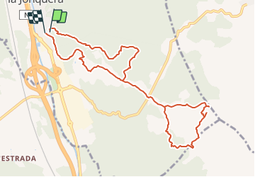
![](/images/other/stat-length.png)
![Excursión A pie La Junquera - Marxa dels dòlmens i ruta dels estanys - Photo](https://media.geolcdn.com/t/1900/400/fedcbff4-20db-4413-b792-cfa0f34dafa2.jpeg&format=pjpeg&maxdim=2)
Marxa dels dòlmens i ruta dels estanys
SityTrail - itinéraires balisés pédestres
Tous les sentiers balisés d’Europe GUIDE+
![Longitud](/images/other/stat-length.png)
![Altitud máxima](https://static1.geolcdn.com/siteimages/upload/files/1508320355ic_sort_altitude_max_24dp.png)
![Desnivel positivo](https://static1.geolcdn.com/siteimages/upload/files/1508320355ic_sort_den_pos_24dp.png)
![Km-Effort](/images/other/stat-length.png)
![Altitud mínima](https://static1.geolcdn.com/siteimages/upload/files/1508320355ic_sort_altitude_min_24dp.png)
![Desnivel negativo](https://static1.geolcdn.com/siteimages/upload/files/1508320355ic_sort_den_neg_24dp.png)
![Boucle](https://static1.geolcdn.com/siteimages/upload/files/16400158638029165_repeat_loop_refresh_sync_direction_icon.png)
![A pie](https://static1.geolcdn.com/sitytour/trail-icons/100.png)
3h17
Dificultad : Fácil
![Escanee este código QR para abrir la excursión en la aplicación SityTrail](https://capi.geolives.com/qq0zvz2zws4bq2lad0pu/sitytour/trails/3110493/qr.png?size=200)
Aplicación GPS de excursión GRATIS
A propósito
Ruta A pie de 11,5 km a descubrir en Cataluña, Gerona, La Junquera. Esta ruta ha sido propuesta por SityTrail - itinéraires balisés pédestres.
Descripción
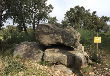
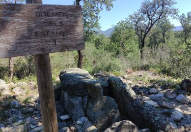
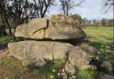
El Centre Excursionista Jonquerenc, organitza des de l’any 1983 la popular Marxa dels Dòlmens, senyalitzada en aquesta ruta. La zona humida dels estanys està inclosa dins el PEIN “Estanys de la Jonquera” i englobat dins els espais de la Xarxa Natura 2000
Sitio web: https://www.itinerannia.net/ca/itineraris/marxa-dels-dolmens-i-ruta-dels-estanys-ruta-15-alt-emporda/
Localización
Comentarios
Excursiones cerca
![Excursión A pie Capmany - Itinerari megalític de Campmany - Photo](https://media.geolcdn.com/t/375/260/869eddc9-99f0-4850-9d15-c9f49ca84b69.jpeg&format=jpg&maxdim=2)
![A pie A pie](https://static1.geolcdn.com/sitytour/trail-icons/100.png)
A pie
![](/images/other/stat-length.png)
![](https://static1.geolcdn.com/siteimages/upload/files/16400158638029165_repeat_loop_refresh_sync_direction_icon.png)
![Excursión A pie La Junquera - PR-C 71 La Jonquera-Portbou - Photo](https://media.geolcdn.com/t/375/260/5e6d3380-2250-4b33-97db-8f0c01794288.jpeg&format=jpg&maxdim=2)
![A pie A pie](https://static1.geolcdn.com/sitytour/trail-icons/100.png)
A pie
![](/images/other/stat-length.png)
![](https://static1.geolcdn.com/siteimages/upload/files/16400158638029165_repeat_loop_refresh_sync_direction_icon.png)
![Excursión Senderismo Le Perthus - penissar - Photo](https://media.geolcdn.com/t/375/260/db553a64-848c-49b3-ac51-caf4a414d04b.jpg&format=jpg&maxdim=2)
![Senderismo Senderismo](https://static1.geolcdn.com/sitytour/trail-icons/101.png)
Senderismo
![](/images/other/stat-length.png)
![](https://static1.geolcdn.com/siteimages/upload/files/16400158638029165_repeat_loop_refresh_sync_direction_icon.png)
![Excursión Senderismo La Junquera - CIRCUIT DES MÉGALITHES depuis EL FOGON - Photo](https://media.geolcdn.com/t/375/260/7a6e5bb6-23f5-4b50-857a-537a11402d8b.jpg&format=jpg&maxdim=2)
![Senderismo Senderismo](https://static1.geolcdn.com/sitytour/trail-icons/101.png)
Senderismo
![](/images/other/stat-length.png)
![](https://static1.geolcdn.com/siteimages/upload/files/16400158638029165_repeat_loop_refresh_sync_direction_icon.png)
![Excursión Senderismo La Junquera - 20230112 Site mégalithique- château Requesens - Photo](https://media.geolcdn.com/t/375/260/434ae223-eff4-4144-bd74-a07ff9e915d6.jpg&format=jpg&maxdim=2)
![Senderismo Senderismo](https://static1.geolcdn.com/sitytour/trail-icons/101.png)
Senderismo
![](/images/other/stat-length.png)
![](https://static1.geolcdn.com/siteimages/upload/files/16400158638029165_repeat_loop_refresh_sync_direction_icon.png)
![Excursión Senderismo Le Perthus - palissades. la carboniere . fort de bellegrade . panissars - Photo](https://media.geolcdn.com/t/375/260/ed24b436-d9f9-4bce-9f3c-0eb2cbedcc4f.jpg&format=jpg&maxdim=2)
![Senderismo Senderismo](https://static1.geolcdn.com/sitytour/trail-icons/101.png)
Senderismo
![](/images/other/stat-length.png)
![](https://static1.geolcdn.com/siteimages/upload/files/16400158638029165_repeat_loop_refresh_sync_direction_icon.png)
![Excursión Senderismo Le Perthus - Panissars_Fort-Belgarde - Photo](https://media.geolcdn.com/t/375/260/ext.jpg?maxdim=2&url=https%3A%2F%2Fservices.sitytrail.com%2FGeolivesWS%2FDownloadMedia.ashx%3FTrailID%3D572198%26Media%3Dfix__20160520173218.jpg)
![Senderismo Senderismo](https://static1.geolcdn.com/sitytour/trail-icons/101.png)
Senderismo
![](/images/other/stat-length.png)
![](https://static1.geolcdn.com/siteimages/upload/files/16400158638029165_repeat_loop_refresh_sync_direction_icon.png)
![Excursión Senderismo Le Perthus - 66 LE PERTHUS - col de Panissars - GR10 - pistes - fort de Bellegarde - Photo](https://media.geolcdn.com/t/375/260/ext.jpg?maxdim=2&url=https%3A%2F%2Fservices.sitytrail.com%2FGeolivesWS%2FDownloadMedia.ashx%3FTrailID%3D473083%26Media%3D20150918174636.jpg)
![Senderismo Senderismo](https://static1.geolcdn.com/sitytour/trail-icons/101.png)
Senderismo
![](/images/other/stat-length.png)
![](https://static1.geolcdn.com/siteimages/upload/files/16400158638029165_repeat_loop_refresh_sync_direction_icon.png)
![Excursión Senderismo Capmany - Capmany Mégalithique_2 - Photo](https://media.geolcdn.com/t/375/260/ext.jpg?maxdim=2&url=https%3A%2F%2Fservices.sitytrail.com%2FGeolivesWS%2FDownloadMedia.ashx%3FTrailID%3D304677%26Media%3D70129613-bd6d-4e80-a4c3-608884f2ea29.jpeg)
![Senderismo Senderismo](https://static1.geolcdn.com/sitytour/trail-icons/101.png)
Senderismo
![](/images/other/stat-length.png)
![](https://static1.geolcdn.com/siteimages/upload/files/16400158638029165_repeat_loop_refresh_sync_direction_icon.png)