![](/images/other/stat-length.png)
![Excursión A pie San Andrés y Sauces - Sendero Autoguiado - Un balcón atravesado entre las brumas - Photo](https://media.geolcdn.com/t/1900/400/ext.pjpeg?maxdim=2&url=https%3A%2F%2Fmedia.geolcdn.com%2Ff%2F1118cbb1-886d-4dc6-a0ac-82615554addb.jpeg)
Sendero Autoguiado - Un balcón atravesado entre las brumas
SityTrail - itinéraires balisés pédestres
Tous les sentiers balisés d’Europe PRO
![Longitud](/images/other/stat-length.png)
Longitud
5,2 km
![Altitud máxima](https://static1.geolcdn.com/siteimages/upload/files/1508320355ic_sort_altitude_max_24dp.png)
Altitud máxima
752 m
![Desnivel positivo](https://static1.geolcdn.com/siteimages/upload/files/1508320355ic_sort_den_pos_24dp.png)
Desnivel positivo
386 m
![Km-Effort](/images/other/stat-length.png)
Km-Effort
10,4 km
![Altitud mínima](https://static1.geolcdn.com/siteimages/upload/files/1508320355ic_sort_altitude_min_24dp.png)
Altitud mínima
464 m
![Desnivel negativo](https://static1.geolcdn.com/siteimages/upload/files/1508320355ic_sort_den_neg_24dp.png)
Desnivel negativo
408 m
![Boucle](https://static1.geolcdn.com/siteimages/upload/files/16400158638029165_repeat_loop_refresh_sync_direction_icon.png)
Boucle
Sí
Baliza
Fecha de creación :
2022-02-14 15:28:32.071
Última modificación :
2022-02-14 15:28:32.071
![A pie](https://static1.geolcdn.com/sitytour/trail-icons/100.png)
2h21
Dificultad : Fácil
![Escanee este código QR para abrir la excursión en la aplicación SityTrail](https://capi.geolives.com/qq0zvz2zws4bq2lad0pu/sitytour/trails/3110202/qr.png?size=200)
Aplicación GPS de excursión GRATIS
A propósito
Ruta A pie de 5,2 km a descubrir en Canarias, Santa Cruz de Tenerife, San Andrés y Sauces. Esta ruta ha sido propuesta por SityTrail - itinéraires balisés pédestres.
Descripción
Sitio web: http://www.senderosdelapalma.es/senderos/lista-de-senderos/senderos-autoguiados/
Localización
País:
Spain
Región :
Canarias
Departamento/provincia :
Santa Cruz de Tenerife
Municipio :
San Andrés y Sauces
Localidad:
Unknown
Salida:(Dec)
Salida:(UTM)
226609 ; 3187917 (28R) N.
Comentarios
Excursiones cerca
![Excursión A pie Barlovento - SL LP 40 Barlovento-La Palmita - Photo](https://media.geolcdn.com/t/375/260/ext.jpg?maxdim=2&url=https%3A%2F%2Fmedia.geolcdn.com%2Ff%2F82ebbd9a-b84a-4fc5-830c-865d1d44e856.jpeg)
![A pie A pie](https://static1.geolcdn.com/sitytour/trail-icons/100.png)
SL LP 40 Barlovento-La Palmita
A pie
Fácil
Barlovento,
Canarias,
Santa Cruz de Tenerife,
Spain
![](/images/other/stat-length.png)
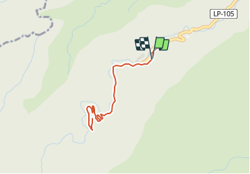
4,3 km | 5,9 km-effort
1h 20min
![](https://static1.geolcdn.com/siteimages/upload/files/16400158638029165_repeat_loop_refresh_sync_direction_icon.png)
No
![Excursión Senderismo San Andrés y Sauces - Wikiloc - La Palma Los Tillos 50% - Photo](https://media.geolcdn.com/t/375/260/ext.jpg?maxdim=2&url=https%3A%2F%2Fmedia.geolcdn.com%2Ff%2F32f861ad-6788-423a-aa28-742950482211.JPG)
![Senderismo Senderismo](https://static1.geolcdn.com/sitytour/trail-icons/101.png)
Wikiloc - La Palma Los Tillos 50%
Senderismo
Difícil
San Andrés y Sauces,
Canarias,
Santa Cruz de Tenerife,
Spain
![](/images/other/stat-length.png)
6,3 km | 12,9 km-effort
3h 57min
![](https://static1.geolcdn.com/siteimages/upload/files/16400158638029165_repeat_loop_refresh_sync_direction_icon.png)
Sí
![Excursión Senderismo Puntallana - La Palma-La Galga-PR2 - Photo](https://media.geolcdn.com/t/375/260/ext.jpg?maxdim=2&url=https%3A%2F%2Fstatic1.geolcdn.com%2Fsiteimages%2Fupload%2Ffiles%2F1553511878bg_sport_marche.png)
![Senderismo Senderismo](https://static1.geolcdn.com/sitytour/trail-icons/101.png)
La Palma-La Galga-PR2
Senderismo
Fácil
Puntallana,
Canarias,
Santa Cruz de Tenerife,
Spain
![](/images/other/stat-length.png)
4,4 km | 7,6 km-effort
1h 20min
![](https://static1.geolcdn.com/siteimages/upload/files/16400158638029165_repeat_loop_refresh_sync_direction_icon.png)
Sí
![Excursión Senderismo San Andrés y Sauces - La Palma - San Andres - Photo](https://media.geolcdn.com/t/375/260/ext.jpg?maxdim=2&url=https%3A%2F%2Fstatic1.geolcdn.com%2Fsiteimages%2Fupload%2Ffiles%2F1553511878bg_sport_marche.png)
![Senderismo Senderismo](https://static1.geolcdn.com/sitytour/trail-icons/101.png)
La Palma - San Andres
Senderismo
Fácil
San Andrés y Sauces,
Canarias,
Santa Cruz de Tenerife,
Spain
![](/images/other/stat-length.png)
7,7 km | 13,9 km-effort
2h 41min
![](https://static1.geolcdn.com/siteimages/upload/files/16400158638029165_repeat_loop_refresh_sync_direction_icon.png)
No
![Excursión Senderismo San Andrés y Sauces - La Palma - Los Tilos - Photo](https://media.geolcdn.com/t/375/260/ext.jpg?maxdim=2&url=https%3A%2F%2Fstatic1.geolcdn.com%2Fsiteimages%2Fupload%2Ffiles%2F1553511878bg_sport_marche.png)
![Senderismo Senderismo](https://static1.geolcdn.com/sitytour/trail-icons/101.png)
La Palma - Los Tilos
Senderismo
Difícil
San Andrés y Sauces,
Canarias,
Santa Cruz de Tenerife,
Spain
![](/images/other/stat-length.png)
21 km | 45 km-effort
6h 37min
![](https://static1.geolcdn.com/siteimages/upload/files/16400158638029165_repeat_loop_refresh_sync_direction_icon.png)
No