![](/images/other/stat-length.png)
![Excursión Senderismo Lieja - Liège - Points de vues du Péri, la Citadelle, Buren, Favechamp, apd du Bvd H. Denis - Photo](https://media.geolcdn.com/t/1900/400/725cfb7c-c81f-427f-8209-9f0430794e42.jpg&format=pjpeg&maxdim=2)
Liège - Points de vues du Péri, la Citadelle, Buren, Favechamp, apd du Bvd H. Denis
David Toussaint
Usuario
![Longitud](/images/other/stat-length.png)
![Altitud máxima](https://static1.geolcdn.com/siteimages/upload/files/1508320355ic_sort_altitude_max_24dp.png)
![Desnivel positivo](https://static1.geolcdn.com/siteimages/upload/files/1508320355ic_sort_den_pos_24dp.png)
![Km-Effort](/images/other/stat-length.png)
![Altitud mínima](https://static1.geolcdn.com/siteimages/upload/files/1508320355ic_sort_altitude_min_24dp.png)
![Desnivel negativo](https://static1.geolcdn.com/siteimages/upload/files/1508320355ic_sort_den_neg_24dp.png)
![Boucle](https://static1.geolcdn.com/siteimages/upload/files/16400158638029165_repeat_loop_refresh_sync_direction_icon.png)
![Senderismo](https://static1.geolcdn.com/sitytour/trail-icons/101.png)
2h05
Dificultad : Medio
![Escanee este código QR para abrir la excursión en la aplicación SityTrail](https://capi.geolives.com/qq0zvz2zws4bq2lad0pu/sitytour/trails/3103455/qr.png?size=200)
Aplicación GPS de excursión GRATIS
A propósito
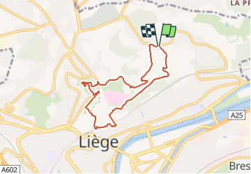
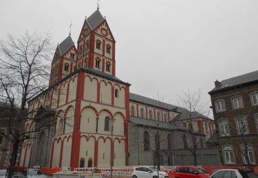
Ruta Senderismo de 6,8 km a descubrir en Valonia, Lieja, Lieja. Esta ruta ha sido propuesta por David Toussaint.
Descripción
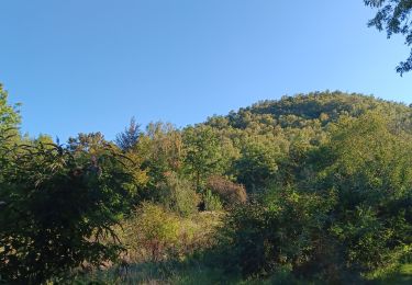
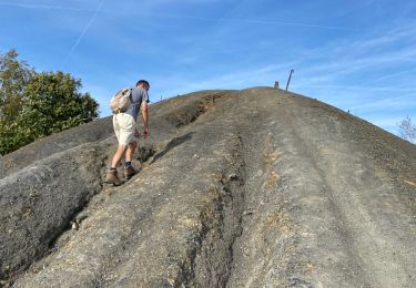
Au départ du Bvd H. Denis, et la rue de la sèche, une belle boucle découvrant des points de vue époustoufflants sur la ville de Liège, via le Péri, le terril Banneux Ancien, les contours du parc de la Citadelle, le Belvédère, la descente par Buren, petit retauration à la Brasserie Curtius, puis traversée des coteaux pour déboucher en bas de pierreuse, remonter via le parc de Favechamp, jusqu'à la Citadelle, que l'on coutourne par l'autre côté, puis rue des glacis, et retour via Banneux ancien, puis la rue Jacquet jusqu'au point de départ. Un régal pour les yeux!
Localización
Comentarios
Excursiones cerca
![Excursión Senderismo Lieja - Nuit du scoutisme - Liège - Photo](https://media.geolcdn.com/t/375/260/9ee5fcc5-2ed6-4f9c-9105-1fa3b4422f73.jpg&format=jpg&maxdim=2)
![Senderismo Senderismo](https://static1.geolcdn.com/sitytour/trail-icons/101.png)
Senderismo
![](/images/other/stat-length.png)
![](https://static1.geolcdn.com/siteimages/upload/files/16400158638029165_repeat_loop_refresh_sync_direction_icon.png)
![Excursión Senderismo Lieja - coteaux de la citadelle liège - Photo](https://media.geolcdn.com/t/375/260/ext.jpg?maxdim=2&url=https%3A%2F%2Fservices.sitytrail.com%2FGeolivesWS%2FDownloadMedia.ashx%3FTrailID%3D114030%26Media%3D89e4d7f6-fadf-43e4-96ab-3cccd7baadb9.jpg)
![Senderismo Senderismo](https://static1.geolcdn.com/sitytour/trail-icons/101.png)
Senderismo
![](/images/other/stat-length.png)
![](https://static1.geolcdn.com/siteimages/upload/files/16400158638029165_repeat_loop_refresh_sync_direction_icon.png)
![Excursión Senderismo Lieja - liege st lambert versant gauche entre ville et nature - Photo](https://media.geolcdn.com/t/375/260/88c52680-ebe2-4244-8d59-4bcee560958c.jpg&format=jpg&maxdim=2)
![Senderismo Senderismo](https://static1.geolcdn.com/sitytour/trail-icons/101.png)
Senderismo
![](/images/other/stat-length.png)
![](https://static1.geolcdn.com/siteimages/upload/files/16400158638029165_repeat_loop_refresh_sync_direction_icon.png)
![Excursión Senderismo Lieja - 2021-03-07_15h45m11_1615128300605_UnnMrtGYyrs - Photo](https://media.geolcdn.com/t/375/260/1db82134-c6f1-4cf9-9ec5-4781d8a78844.jpg&format=jpg&maxdim=2)
![Senderismo Senderismo](https://static1.geolcdn.com/sitytour/trail-icons/101.png)
Senderismo
![](/images/other/stat-length.png)
![](https://static1.geolcdn.com/siteimages/upload/files/16400158638029165_repeat_loop_refresh_sync_direction_icon.png)
![Excursión Senderismo Lieja - Liège - Au fil de l'eau - Photo](https://media.geolcdn.com/t/375/260/8c09c893-4ffe-470b-95bd-9bda5ce59d47.jpg&format=jpg&maxdim=2)
![Senderismo Senderismo](https://static1.geolcdn.com/sitytour/trail-icons/101.png)
Senderismo
![](/images/other/stat-length.png)
![](https://static1.geolcdn.com/siteimages/upload/files/16400158638029165_repeat_loop_refresh_sync_direction_icon.png)
![Excursión Senderismo Lieja - 20231029 - TOTEMUS Liège](https://media.geolcdn.com/t/375/260/7b2ecb7c-b811-49e3-b8cb-f4a6ee7afc27.jpeg&format=jpg&maxdim=2)
![Senderismo Senderismo](https://static1.geolcdn.com/sitytour/trail-icons/101.png)
Senderismo
![](/images/other/stat-length.png)
![](https://static1.geolcdn.com/siteimages/upload/files/16400158638029165_repeat_loop_refresh_sync_direction_icon.png)
![Excursión Senderismo Lieja - tour des terrils liégeois - Photo](https://media.geolcdn.com/t/375/260/ad42a46a-dbdf-4e4e-8410-610288228746.jpg&format=jpg&maxdim=2)
![Senderismo Senderismo](https://static1.geolcdn.com/sitytour/trail-icons/101.png)
Senderismo
![](/images/other/stat-length.png)
![](https://static1.geolcdn.com/siteimages/upload/files/16400158638029165_repeat_loop_refresh_sync_direction_icon.png)
![Senderismo Senderismo](https://static1.geolcdn.com/sitytour/trail-icons/101.png)
Senderismo
![](/images/other/stat-length.png)
![](https://static1.geolcdn.com/siteimages/upload/files/16400158638029165_repeat_loop_refresh_sync_direction_icon.png)
![Excursión Senderismo Lieja - Jupille Terril du Hasard 23,2 km - Photo](https://media.geolcdn.com/t/375/260/2ea62883-868d-452c-bcdd-b45e22ce3fff.jpeg&format=jpg&maxdim=2)
![Senderismo Senderismo](https://static1.geolcdn.com/sitytour/trail-icons/101.png)
Senderismo
![](/images/other/stat-length.png)
![](https://static1.geolcdn.com/siteimages/upload/files/16400158638029165_repeat_loop_refresh_sync_direction_icon.png)