![](/images/other/stat-length.png)
![Excursión A pie Gomadingen - Rose-Rundweg - Photo](https://media.geolcdn.com/t/1900/400/ext.pjpeg?maxdim=2&url=https%3A%2F%2Fmedia.geolcdn.com%2Ff%2F889fb613-b6a9-4485-b124-f8cd332ce1de.jpeg)
Rose-Rundweg
SityTrail - itinéraires balisés pédestres
Tous les sentiers balisés d’Europe PRO
![Longitud](/images/other/stat-length.png)
Longitud
5,1 km
![Altitud máxima](https://static1.geolcdn.com/siteimages/upload/files/1508320355ic_sort_altitude_max_24dp.png)
Altitud máxima
780 m
![Desnivel positivo](https://static1.geolcdn.com/siteimages/upload/files/1508320355ic_sort_den_pos_24dp.png)
Desnivel positivo
99 m
![Km-Effort](/images/other/stat-length.png)
Km-Effort
6,3 km
![Altitud mínima](https://static1.geolcdn.com/siteimages/upload/files/1508320355ic_sort_altitude_min_24dp.png)
Altitud mínima
719 m
![Desnivel negativo](https://static1.geolcdn.com/siteimages/upload/files/1508320355ic_sort_den_neg_24dp.png)
Desnivel negativo
76 m
![Boucle](https://static1.geolcdn.com/siteimages/upload/files/16400158638029165_repeat_loop_refresh_sync_direction_icon.png)
Boucle
No
Baliza
Fecha de creación :
2022-02-11 20:50:16.031
Última modificación :
2022-02-11 20:50:16.031
![A pie](https://static1.geolcdn.com/sitytour/trail-icons/100.png)
1h26
Dificultad : Fácil
![Escanee este código QR para abrir la excursión en la aplicación SityTrail](https://capi.geolives.com/qq0zvz2zws4bq2lad0pu/sitytour/trails/3102251/qr.png?size=200)
Aplicación GPS de excursión GRATIS
A propósito
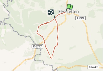
Ruta A pie de 5,1 km a descubrir en Baden-Wurtemberg, Landkreis Reutlingen, Gomadingen. Esta ruta ha sido propuesta por SityTrail - itinéraires balisés pédestres.
Descripción
Trail created by Bio-Hotel und -Restaurant Rose.
Symbol: hellrote Rose auf weiß
Localización
País:
Germany
Región :
Baden-Wurtemberg
Departamento/provincia :
Landkreis Reutlingen
Municipio :
Gomadingen
Localidad:
Unknown
Salida:(Dec)
Salida:(UTM)
532054 ; 5351937 (32U) N.
Comentarios
Excursiones cerca
![Excursión A pie Gomadingen - hochgehackert - Photo](https://media.geolcdn.com/t/375/260/ext.jpg?maxdim=2&url=https%3A%2F%2Fmedia.geolcdn.com%2Ff%2F2dca7dff-ee94-4051-8b75-0ea452a512f9.jpeg)
![A pie A pie](https://static1.geolcdn.com/sitytour/trail-icons/100.png)
hochgehackert
A pie
Fácil
Gomadingen,
Baden-Wurtemberg,
Landkreis Reutlingen,
Germany
![](/images/other/stat-length.png)
9,2 km | 11,3 km-effort
2h 34min
![](https://static1.geolcdn.com/siteimages/upload/files/16400158638029165_repeat_loop_refresh_sync_direction_icon.png)
Sí
![Excursión A pie Gomadingen - hochgehschätzt - Photo](https://media.geolcdn.com/t/375/260/ext.jpg?maxdim=2&url=https%3A%2F%2Fmedia.geolcdn.com%2Ff%2F2d6c90c8-519d-43f8-977e-d2d00fe2bd1e.jpeg)
![A pie A pie](https://static1.geolcdn.com/sitytour/trail-icons/100.png)
hochgehschätzt
A pie
Fácil
Gomadingen,
Baden-Wurtemberg,
Landkreis Reutlingen,
Germany
![](/images/other/stat-length.png)
4,7 km | 5,7 km-effort
1h 17min
![](https://static1.geolcdn.com/siteimages/upload/files/16400158638029165_repeat_loop_refresh_sync_direction_icon.png)
No
![Excursión A pie Gomadingen - hochgehlautert - Photo](https://media.geolcdn.com/t/375/260/ext.jpg?maxdim=2&url=https%3A%2F%2Fstatic1.geolcdn.com%2Fsiteimages%2Fupload%2Ffiles%2F1545311037marcheuse_200dpi.jpg)
![A pie A pie](https://static1.geolcdn.com/sitytour/trail-icons/100.png)
hochgehlautert
A pie
Fácil
Gomadingen,
Baden-Wurtemberg,
Landkreis Reutlingen,
Germany
![](/images/other/stat-length.png)
10,6 km | 14,9 km-effort
3h 23min
![](https://static1.geolcdn.com/siteimages/upload/files/16400158638029165_repeat_loop_refresh_sync_direction_icon.png)
Sí
![Excursión Senderismo Gomadingen - w-duitsland-naturtheater-hayingen - Photo](https://media.geolcdn.com/t/375/260/ext.jpg?maxdim=2&url=https%3A%2F%2Fstatic1.geolcdn.com%2Fsiteimages%2Fupload%2Ffiles%2F1553511878bg_sport_marche.png)
![Senderismo Senderismo](https://static1.geolcdn.com/sitytour/trail-icons/101.png)
w-duitsland-naturtheater-hayingen
Senderismo
Muy fácil
Gomadingen,
Baden-Wurtemberg,
Landkreis Reutlingen,
Germany
![](/images/other/stat-length.png)
3,4 km | 4,5 km-effort
Desconocido
![](https://static1.geolcdn.com/siteimages/upload/files/16400158638029165_repeat_loop_refresh_sync_direction_icon.png)
Sí
![Excursión Senderismo Gomadingen - w-duitsland-grosse-lauter - Photo](https://media.geolcdn.com/t/375/260/ext.jpg?maxdim=2&url=https%3A%2F%2Fstatic1.geolcdn.com%2Fsiteimages%2Fupload%2Ffiles%2F1553511878bg_sport_marche.png)
![Senderismo Senderismo](https://static1.geolcdn.com/sitytour/trail-icons/101.png)
w-duitsland-grosse-lauter
Senderismo
Muy fácil
Gomadingen,
Baden-Wurtemberg,
Landkreis Reutlingen,
Germany
![](/images/other/stat-length.png)
5,5 km | 7,1 km-effort
Desconocido
![](https://static1.geolcdn.com/siteimages/upload/files/16400158638029165_repeat_loop_refresh_sync_direction_icon.png)
Sí