![](/images/other/stat-length.png)
![Excursión A pie Guldental - Guldentaler Krönchen - Photo](https://media.geolcdn.com/t/1900/400/ext.pjpeg?maxdim=2&url=https%3A%2F%2Fmedia.geolcdn.com%2Ff%2Fef06a4f4-b98b-48ce-b3a2-a35eac2a946a.jpeg)
Guldentaler Krönchen
SityTrail - itinéraires balisés pédestres
Tous les sentiers balisés d’Europe PRO
![Longitud](/images/other/stat-length.png)
Longitud
8,4 km
![Altitud máxima](https://static1.geolcdn.com/siteimages/upload/files/1508320355ic_sort_altitude_max_24dp.png)
Altitud máxima
238 m
![Desnivel positivo](https://static1.geolcdn.com/siteimages/upload/files/1508320355ic_sort_den_pos_24dp.png)
Desnivel positivo
199 m
![Km-Effort](/images/other/stat-length.png)
Km-Effort
11,1 km
![Altitud mínima](https://static1.geolcdn.com/siteimages/upload/files/1508320355ic_sort_altitude_min_24dp.png)
Altitud mínima
141 m
![Desnivel negativo](https://static1.geolcdn.com/siteimages/upload/files/1508320355ic_sort_den_neg_24dp.png)
Desnivel negativo
203 m
![Boucle](https://static1.geolcdn.com/siteimages/upload/files/16400158638029165_repeat_loop_refresh_sync_direction_icon.png)
Boucle
Sí
Baliza
Fecha de creación :
2022-02-11 20:28:56.207
Última modificación :
2022-02-11 20:28:56.207
![A pie](https://static1.geolcdn.com/sitytour/trail-icons/100.png)
2h30
Dificultad : Fácil
![Escanee este código QR para abrir la excursión en la aplicación SityTrail](https://capi.geolives.com/qq0zvz2zws4bq2lad0pu/sitytour/trails/3101867/qr.png?size=200)
Aplicación GPS de excursión GRATIS
A propósito
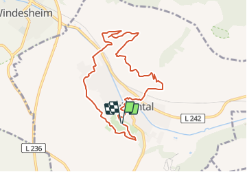
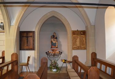
Ruta A pie de 8,4 km a descubrir en Renania-Palatinado, Landkreis Bad Kreuznach, Guldental. Esta ruta ha sido propuesta por SityTrail - itinéraires balisés pédestres.
Descripción
Symbol: gelbe Krone auf blauem Hintergrund
Sitio web: https://www.guldental.de/project/wanderwege-rund-um-guldental/
Localización
País:
Germany
Región :
Renania-Palatinado
Departamento/provincia :
Landkreis Bad Kreuznach
Municipio :
Guldental
Localidad:
Unknown
Salida:(Dec)
Salida:(UTM)
416699 ; 5526793 (32U) N.
Comentarios
Excursiones cerca
![Excursión A pie Bretzenheim - Vitaltour Eremitenpfad - Photo](https://media.geolcdn.com/t/375/260/ext.jpg?maxdim=2&url=https%3A%2F%2Fmedia.geolcdn.com%2Ff%2F1d50e95c-f083-4176-872d-58483e9ebd04.jpeg)
![A pie A pie](https://static1.geolcdn.com/sitytour/trail-icons/100.png)
Vitaltour Eremitenpfad
A pie
Fácil
Bretzenheim,
Renania-Palatinado,
Landkreis Bad Kreuznach,
Germany
![](/images/other/stat-length.png)
9,4 km | 12,3 km-effort
2h 47min
![](https://static1.geolcdn.com/siteimages/upload/files/16400158638029165_repeat_loop_refresh_sync_direction_icon.png)
Sí
![Excursión A pie Guldental - Guldentaler Weinwanderweg - Photo](https://media.geolcdn.com/t/375/260/ext.jpg?maxdim=2&url=https%3A%2F%2Fmedia.geolcdn.com%2Ff%2Fb0212427-aeb5-45a0-9962-1a61044dbb06.jpeg)
![A pie A pie](https://static1.geolcdn.com/sitytour/trail-icons/100.png)
Guldentaler Weinwanderweg
A pie
Fácil
Guldental,
Renania-Palatinado,
Landkreis Bad Kreuznach,
Germany
![](/images/other/stat-length.png)
5,4 km | 6,9 km-effort
1h 34min
![](https://static1.geolcdn.com/siteimages/upload/files/16400158638029165_repeat_loop_refresh_sync_direction_icon.png)
Sí
![Excursión A pie Windesheim - VitalTour Wald, Wein & Horizonte - Photo](https://media.geolcdn.com/t/375/260/ext.jpg?maxdim=2&url=https%3A%2F%2Fmedia.geolcdn.com%2Ff%2Fef06a4f4-b98b-48ce-b3a2-a35eac2a946a.jpeg)
![A pie A pie](https://static1.geolcdn.com/sitytour/trail-icons/100.png)
VitalTour Wald, Wein & Horizonte
A pie
Fácil
Windesheim,
Renania-Palatinado,
Landkreis Bad Kreuznach,
Germany
![](/images/other/stat-length.png)
9,8 km | 13,6 km-effort
3h 5min
![](https://static1.geolcdn.com/siteimages/upload/files/16400158638029165_repeat_loop_refresh_sync_direction_icon.png)
No
![Excursión A pie Gutenberg - Gutenbergweg - Photo](https://media.geolcdn.com/t/375/260/ext.jpg?maxdim=2&url=https%3A%2F%2Fstatic1.geolcdn.com%2Fsiteimages%2Fupload%2Ffiles%2F1545311037marcheuse_200dpi.jpg)
![A pie A pie](https://static1.geolcdn.com/sitytour/trail-icons/100.png)
Gutenbergweg
A pie
Fácil
Gutenberg,
Renania-Palatinado,
Landkreis Bad Kreuznach,
Germany
![](/images/other/stat-length.png)
5,1 km | 6,8 km-effort
1h 32min
![](https://static1.geolcdn.com/siteimages/upload/files/16400158638029165_repeat_loop_refresh_sync_direction_icon.png)
Sí