![](/images/other/stat-length.png)
![Excursión A pie Remagen - Panoramaweg Remagen (A5) - Photo](https://media.geolcdn.com/t/1900/400/ext.pjpeg?maxdim=2&url=https%3A%2F%2Fstatic1.geolcdn.com%2Fsiteimages%2Fupload%2Ffiles%2F1545311037marcheuse_200dpi.jpg)
Panoramaweg Remagen (A5)
SityTrail - itinéraires balisés pédestres
Tous les sentiers balisés d’Europe PRO
![Longitud](/images/other/stat-length.png)
Longitud
4,7 km
![Altitud máxima](https://static1.geolcdn.com/siteimages/upload/files/1508320355ic_sort_altitude_max_24dp.png)
Altitud máxima
203 m
![Desnivel positivo](https://static1.geolcdn.com/siteimages/upload/files/1508320355ic_sort_den_pos_24dp.png)
Desnivel positivo
135 m
![Km-Effort](/images/other/stat-length.png)
Km-Effort
6,5 km
![Altitud mínima](https://static1.geolcdn.com/siteimages/upload/files/1508320355ic_sort_altitude_min_24dp.png)
Altitud mínima
95 m
![Desnivel negativo](https://static1.geolcdn.com/siteimages/upload/files/1508320355ic_sort_den_neg_24dp.png)
Desnivel negativo
142 m
![Boucle](https://static1.geolcdn.com/siteimages/upload/files/16400158638029165_repeat_loop_refresh_sync_direction_icon.png)
Boucle
No
Baliza
Fecha de creación :
2022-02-11 20:19:02.556
Última modificación :
2022-02-11 20:19:02.556
![A pie](https://static1.geolcdn.com/sitytour/trail-icons/100.png)
1h28
Dificultad : Fácil
![Escanee este código QR para abrir la excursión en la aplicación SityTrail](https://capi.geolives.com/qq0zvz2zws4bq2lad0pu/sitytour/trails/3101664/qr.png?size=200)
Aplicación GPS de excursión GRATIS
A propósito
Ruta A pie de 4,7 km a descubrir en Renania-Palatinado, Landkreis Ahrweiler, Remagen. Esta ruta ha sido propuesta por SityTrail - itinéraires balisés pédestres.
Descripción
Trail created by Verschönerungsverein Remagen e.V..
Symbol: grüne Plakette mit Aufschrift A5
Sitio web: https://www.verschoenerungsverein-remagen.de/wanderwege.html
Localización
País:
Germany
Región :
Renania-Palatinado
Departamento/provincia :
Landkreis Ahrweiler
Municipio :
Remagen
Localidad:
Unknown
Salida:(Dec)
Salida:(UTM)
374415 ; 5603179 (32U) N.
Comentarios
Excursiones cerca
![Excursión A pie Bad Neuenahr-Ahrweiler - Rundweg 8 Gimmingen - Photo](https://media.geolcdn.com/t/375/260/ext.jpg?maxdim=2&url=https%3A%2F%2Fmedia.geolcdn.com%2Ff%2Fafe28d54-8362-474d-8d66-b77f50c689dd.jpeg)
![A pie A pie](https://static1.geolcdn.com/sitytour/trail-icons/100.png)
Rundweg 8 Gimmingen
A pie
Fácil
Bad Neuenahr-Ahrweiler,
Renania-Palatinado,
Landkreis Ahrweiler,
Germany
![](/images/other/stat-length.png)
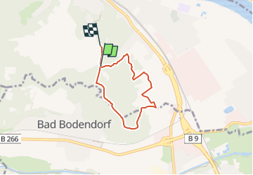
10,7 km | 15,2 km-effort
3h 26min
![](https://static1.geolcdn.com/siteimages/upload/files/16400158638029165_repeat_loop_refresh_sync_direction_icon.png)
Sí
![Excursión A pie Bruchhausen - Rotbäckchen Rundwanderweg - Photo](https://media.geolcdn.com/t/375/260/ext.jpg?maxdim=2&url=https%3A%2F%2Fmedia.geolcdn.com%2Ff%2F1dd5c4a7-c3a6-459c-9cef-b7e5315b6005.jpeg)
![A pie A pie](https://static1.geolcdn.com/sitytour/trail-icons/100.png)
Rotbäckchen Rundwanderweg
A pie
Fácil
Bruchhausen,
Renania-Palatinado,
Landkreis Neuwied,
Germany
![](/images/other/stat-length.png)
11,1 km | 14,1 km-effort
3h 11min
![](https://static1.geolcdn.com/siteimages/upload/files/16400158638029165_repeat_loop_refresh_sync_direction_icon.png)
Sí
![Excursión A pie Remagen - Apollinaris-Schleife (Rheinburgenweg Rundtour) - Photo](https://media.geolcdn.com/t/375/260/ext.jpg?maxdim=2&url=https%3A%2F%2Fmedia.geolcdn.com%2Ff%2Fafe28d54-8362-474d-8d66-b77f50c689dd.jpeg)
![A pie A pie](https://static1.geolcdn.com/sitytour/trail-icons/100.png)
Apollinaris-Schleife (Rheinburgenweg Rundtour)
A pie
Fácil
Remagen,
Renania-Palatinado,
Landkreis Ahrweiler,
Germany
![](/images/other/stat-length.png)
12,7 km | 16,4 km-effort
3h 43min
![](https://static1.geolcdn.com/siteimages/upload/files/16400158638029165_repeat_loop_refresh_sync_direction_icon.png)
Sí
![Excursión A pie Remagen - [1] Oberwinter Wanderweg (Oberwinter - Rolandseck) - Photo](https://media.geolcdn.com/t/375/260/ext.jpg?maxdim=2&url=https%3A%2F%2Fmedia.geolcdn.com%2Ff%2F25784967-1970-4af5-8d60-8f5ed7fdcfe9.jpeg)
![A pie A pie](https://static1.geolcdn.com/sitytour/trail-icons/100.png)
[1] Oberwinter Wanderweg (Oberwinter - Rolandseck)
A pie
Fácil
Remagen,
Renania-Palatinado,
Landkreis Ahrweiler,
Germany
![](/images/other/stat-length.png)
3,7 km | 5,2 km-effort
1h 10min
![](https://static1.geolcdn.com/siteimages/upload/files/16400158638029165_repeat_loop_refresh_sync_direction_icon.png)
No
![Excursión A pie Sinzig - Rundweg 7 Bad Bodendorf - Photo](https://media.geolcdn.com/t/375/260/ext.jpg?maxdim=2&url=https%3A%2F%2Fmedia.geolcdn.com%2Ff%2Fd3fff6ae-8a86-4233-9da6-73de21a37b8c.jpeg)
![A pie A pie](https://static1.geolcdn.com/sitytour/trail-icons/100.png)
Rundweg 7 Bad Bodendorf
A pie
Fácil
Sinzig,
Renania-Palatinado,
Landkreis Ahrweiler,
Germany
![](/images/other/stat-length.png)
8,8 km | 11,1 km-effort
2h 30min
![](https://static1.geolcdn.com/siteimages/upload/files/16400158638029165_repeat_loop_refresh_sync_direction_icon.png)
Sí
![Excursión A pie Bad Neuenahr-Ahrweiler - Rundweg A2 Gimmingen - Photo](https://media.geolcdn.com/t/375/260/ext.jpg?maxdim=2&url=https%3A%2F%2Fmedia.geolcdn.com%2Ff%2Ffc23cae3-4d12-45b0-899f-2f205d4ce91d.jpeg)
![A pie A pie](https://static1.geolcdn.com/sitytour/trail-icons/100.png)
Rundweg A2 Gimmingen
A pie
Fácil
Bad Neuenahr-Ahrweiler,
Renania-Palatinado,
Landkreis Ahrweiler,
Germany
![](/images/other/stat-length.png)
7 km | 9,5 km-effort
2h 8min
![](https://static1.geolcdn.com/siteimages/upload/files/16400158638029165_repeat_loop_refresh_sync_direction_icon.png)
Sí
![Excursión A pie Remagen - Wanderweg Remagen - Photo](https://media.geolcdn.com/t/375/260/ext.jpg?maxdim=2&url=https%3A%2F%2Fmedia.geolcdn.com%2Ff%2Fafe28d54-8362-474d-8d66-b77f50c689dd.jpeg)
![A pie A pie](https://static1.geolcdn.com/sitytour/trail-icons/100.png)
Wanderweg Remagen
A pie
Fácil
Remagen,
Renania-Palatinado,
Landkreis Ahrweiler,
Germany
![](/images/other/stat-length.png)
10 km | 13,8 km-effort
3h 7min
![](https://static1.geolcdn.com/siteimages/upload/files/16400158638029165_repeat_loop_refresh_sync_direction_icon.png)
Sí
![Excursión A pie Remagen - DE-A3 - Photo](https://media.geolcdn.com/t/375/260/ext.jpg?maxdim=2&url=https%3A%2F%2Fmedia.geolcdn.com%2Ff%2F5e7c6f42-f88c-4062-9277-171320514dad.jpeg)
![A pie A pie](https://static1.geolcdn.com/sitytour/trail-icons/100.png)
DE-A3
A pie
Fácil
Remagen,
Renania-Palatinado,
Landkreis Ahrweiler,
Germany
![](/images/other/stat-length.png)
4,7 km | 6,3 km-effort
1h 26min
![](https://static1.geolcdn.com/siteimages/upload/files/16400158638029165_repeat_loop_refresh_sync_direction_icon.png)
Sí
![Excursión A pie Ockenfels - LZ15 - Rundwanderweg Ockenfels - Photo](https://media.geolcdn.com/t/375/260/ext.jpg?maxdim=2&url=https%3A%2F%2Fstatic1.geolcdn.com%2Fsiteimages%2Fupload%2Ffiles%2F1545311037marcheuse_200dpi.jpg)
![A pie A pie](https://static1.geolcdn.com/sitytour/trail-icons/100.png)
LZ15 - Rundwanderweg Ockenfels
A pie
Fácil
Ockenfels,
Renania-Palatinado,
Landkreis Neuwied,
Germany
![](/images/other/stat-length.png)
6,2 km | 8,1 km-effort
1h 51min
![](https://static1.geolcdn.com/siteimages/upload/files/16400158638029165_repeat_loop_refresh_sync_direction_icon.png)
Sí