![](/images/other/stat-length.png)
![Excursión A pie Hafenlohr - Kulturweg Marktheidenfeld 4 - Photo](https://media.geolcdn.com/t/1900/400/b9ec35cb-36ef-400c-825c-eabdfefdcb12.jpeg&format=pjpeg&maxdim=2)
Kulturweg Marktheidenfeld 4
SityTrail - itinéraires balisés pédestres
Tous les sentiers balisés d’Europe GUIDE+
![Longitud](/images/other/stat-length.png)
![Altitud máxima](https://static1.geolcdn.com/siteimages/upload/files/1508320355ic_sort_altitude_max_24dp.png)
![Desnivel positivo](https://static1.geolcdn.com/siteimages/upload/files/1508320355ic_sort_den_pos_24dp.png)
![Km-Effort](/images/other/stat-length.png)
![Altitud mínima](https://static1.geolcdn.com/siteimages/upload/files/1508320355ic_sort_altitude_min_24dp.png)
![Desnivel negativo](https://static1.geolcdn.com/siteimages/upload/files/1508320355ic_sort_den_neg_24dp.png)
![Boucle](https://static1.geolcdn.com/siteimages/upload/files/16400158638029165_repeat_loop_refresh_sync_direction_icon.png)
![A pie](https://static1.geolcdn.com/sitytour/trail-icons/100.png)
3h45
Dificultad : Fácil
![Escanee este código QR para abrir la excursión en la aplicación SityTrail](https://capi.geolives.com/qq0zvz2zws4bq2lad0pu/sitytour/trails/3100680/qr.png?size=200)
Aplicación GPS de excursión GRATIS
A propósito
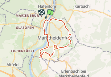
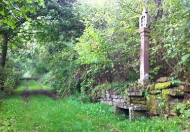
Ruta A pie de 12,5 km a descubrir en Baviera, Landkreis Main-Spessart, Hafenlohr. Esta ruta ha sido propuesta por SityTrail - itinéraires balisés pédestres.
Descripción
Trail created by Archäologisches Spessartprojekt.
Symbol: Europasymbol mit Wikingerschiff
Sitio web: https://www.spessartprojekt.de/kulturwege/marktheidenfeld-ueber-sieben-huegel-kannst-du-gehn/
Localización
Comentarios
Excursiones cerca
![Excursión A pie Rothenfels - Ortswanderweg Rothenfels 1 - Photo](https://media.geolcdn.com/t/375/260/e92e1742-9d87-4f2f-a51f-5dde71bb21f3.jpeg&format=jpg&maxdim=2)
![A pie A pie](https://static1.geolcdn.com/sitytour/trail-icons/100.png)
A pie
![](/images/other/stat-length.png)
![](https://static1.geolcdn.com/siteimages/upload/files/16400158638029165_repeat_loop_refresh_sync_direction_icon.png)
![Excursión A pie Rothenfels - Ortswanderweg Rothenfels 2 - Photo](https://media.geolcdn.com/t/375/260/e92e1742-9d87-4f2f-a51f-5dde71bb21f3.jpeg&format=jpg&maxdim=2)
![A pie A pie](https://static1.geolcdn.com/sitytour/trail-icons/100.png)
A pie
![](/images/other/stat-length.png)
![](https://static1.geolcdn.com/siteimages/upload/files/16400158638029165_repeat_loop_refresh_sync_direction_icon.png)
![Excursión A pie Esselbach - Ortswanderweg Hafenlohr 5 - Photo](https://media.geolcdn.com/t/375/260/05e74058-ad4f-419d-91de-28c351c0d83b.jpeg&format=jpg&maxdim=2)
![A pie A pie](https://static1.geolcdn.com/sitytour/trail-icons/100.png)
A pie
![](/images/other/stat-length.png)
![](https://static1.geolcdn.com/siteimages/upload/files/16400158638029165_repeat_loop_refresh_sync_direction_icon.png)
![Excursión A pie Esselbach - Ortswanderweg Esselbach 5 - Photo](https://media.geolcdn.com/t/375/260/5d40fa64-ace5-41c5-89d4-c6e8db64cc9b.jpeg&format=jpg&maxdim=2)
![A pie A pie](https://static1.geolcdn.com/sitytour/trail-icons/100.png)
A pie
![](/images/other/stat-length.png)
![](https://static1.geolcdn.com/siteimages/upload/files/16400158638029165_repeat_loop_refresh_sync_direction_icon.png)
![Excursión A pie Esselbach - Ortswanderweg Esselbach 6 - Photo](https://media.geolcdn.com/t/375/260/5d40fa64-ace5-41c5-89d4-c6e8db64cc9b.jpeg&format=jpg&maxdim=2)
![A pie A pie](https://static1.geolcdn.com/sitytour/trail-icons/100.png)
A pie
![](/images/other/stat-length.png)
![](https://static1.geolcdn.com/siteimages/upload/files/16400158638029165_repeat_loop_refresh_sync_direction_icon.png)
![Excursión A pie Esselbach - Ortswanderweg Esselbach 7 - Photo](https://media.geolcdn.com/t/375/260/5d40fa64-ace5-41c5-89d4-c6e8db64cc9b.jpeg&format=jpg&maxdim=2)
![A pie A pie](https://static1.geolcdn.com/sitytour/trail-icons/100.png)
A pie
![](/images/other/stat-length.png)
![](https://static1.geolcdn.com/siteimages/upload/files/16400158638029165_repeat_loop_refresh_sync_direction_icon.png)
![Excursión A pie Marktheidenfeld - Kulturweg Marktheidenfeld 3 - Photo](https://media.geolcdn.com/t/375/260/fdae736d-99ec-4667-aed1-e16d1b2cc3b9.jpeg&format=jpg&maxdim=2)
![A pie A pie](https://static1.geolcdn.com/sitytour/trail-icons/100.png)
A pie
![](/images/other/stat-length.png)
![](https://static1.geolcdn.com/siteimages/upload/files/16400158638029165_repeat_loop_refresh_sync_direction_icon.png)
![Excursión A pie Esselbach - Ortswanderweg Esselbach 2 - Photo](https://media.geolcdn.com/t/375/260/05e74058-ad4f-419d-91de-28c351c0d83b.jpeg&format=jpg&maxdim=2)
![A pie A pie](https://static1.geolcdn.com/sitytour/trail-icons/100.png)
A pie
![](/images/other/stat-length.png)
![](https://static1.geolcdn.com/siteimages/upload/files/16400158638029165_repeat_loop_refresh_sync_direction_icon.png)
![Excursión A pie Marktheidenfeld - Kulturweg Marktheidenfeld 1 - Photo](https://media.geolcdn.com/t/375/260/6aa148b7-68e2-4c04-9415-64d533ca4eff.jpeg&format=jpg&maxdim=2)
![A pie A pie](https://static1.geolcdn.com/sitytour/trail-icons/100.png)
A pie
![](/images/other/stat-length.png)
![](https://static1.geolcdn.com/siteimages/upload/files/16400158638029165_repeat_loop_refresh_sync_direction_icon.png)