![](/images/other/stat-length.png)
![Excursión A pie Müllenbach - Himmel und Erd - Photo](https://media.geolcdn.com/t/1900/400/ext.pjpeg?maxdim=2&url=https%3A%2F%2Fstatic1.geolcdn.com%2Fsiteimages%2Fupload%2Ffiles%2F1545311037marcheuse_200dpi.jpg)
Himmel und Erd
SityTrail - itinéraires balisés pédestres
Tous les sentiers balisés d’Europe GUIDE+
![Longitud](/images/other/stat-length.png)
![Altitud máxima](https://static1.geolcdn.com/siteimages/upload/files/1508320355ic_sort_altitude_max_24dp.png)
![Desnivel positivo](https://static1.geolcdn.com/siteimages/upload/files/1508320355ic_sort_den_pos_24dp.png)
![Km-Effort](/images/other/stat-length.png)
![Altitud mínima](https://static1.geolcdn.com/siteimages/upload/files/1508320355ic_sort_altitude_min_24dp.png)
![Desnivel negativo](https://static1.geolcdn.com/siteimages/upload/files/1508320355ic_sort_den_neg_24dp.png)
![Boucle](https://static1.geolcdn.com/siteimages/upload/files/16400158638029165_repeat_loop_refresh_sync_direction_icon.png)
![A pie](https://static1.geolcdn.com/sitytour/trail-icons/100.png)
1h26
Dificultad : Fácil
![Escanee este código QR para abrir la excursión en la aplicación SityTrail](https://capi.geolives.com/qq0zvz2zws4bq2lad0pu/sitytour/trails/3100607/qr.png?size=200)
Aplicación GPS de excursión GRATIS
A propósito
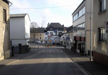
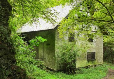
Ruta A pie de 5,1 km a descubrir en Renania-Palatinado, Landkreis Cochem-Zell, Müllenbach. Esta ruta ha sido propuesta por SityTrail - itinéraires balisés pédestres.
Descripción
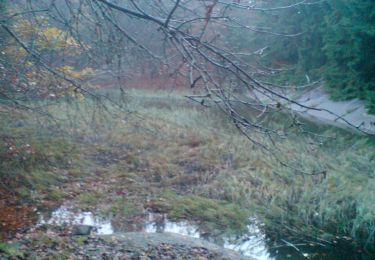
Die geführte Gruppen-Erlebniswanderung „Himmel und Erd“ macht Geschichte hautnah erlebbar. Von der „Erd“, dem ehemaligen Schieferbergbau geht es zum „Himmel“, dem eindrucksvollen Kloster Maria Martental.
Sitio web: https://www.schieferland-kaisersesch.de/a-himmel-erd
Localización
Comentarios
Excursiones cerca
![Excursión A pie Kaisersesch - Ortswanderweg 2 im Bereich Kaisersesch und Masburg - Photo](https://media.geolcdn.com/t/375/260/e1e8438d-ce4f-48d0-b541-cbe19f515512.jpeg&format=jpg&maxdim=2)
![A pie A pie](https://static1.geolcdn.com/sitytour/trail-icons/100.png)
A pie
![](/images/other/stat-length.png)
![](https://static1.geolcdn.com/siteimages/upload/files/16400158638029165_repeat_loop_refresh_sync_direction_icon.png)
![Excursión A pie Masburg - Ortswanderweg 1 im Bereich Kaisersesch und Masburg - Photo](https://media.geolcdn.com/t/375/260/e1e8438d-ce4f-48d0-b541-cbe19f515512.jpeg&format=jpg&maxdim=2)
![A pie A pie](https://static1.geolcdn.com/sitytour/trail-icons/100.png)
A pie
![](/images/other/stat-length.png)
![](https://static1.geolcdn.com/siteimages/upload/files/16400158638029165_repeat_loop_refresh_sync_direction_icon.png)
![Excursión A pie Masburg - Steinbach Rundweg Masburg - Photo](https://media.geolcdn.com/t/375/260/8ae618a7-843b-4ed4-9e9f-523a50c2f4ed.jpeg&format=jpg&maxdim=2)
![A pie A pie](https://static1.geolcdn.com/sitytour/trail-icons/100.png)
A pie
![](/images/other/stat-length.png)
![](https://static1.geolcdn.com/siteimages/upload/files/16400158638029165_repeat_loop_refresh_sync_direction_icon.png)
![Excursión A pie Kaisersesch - Naturlehrpfad Kaisersesch Flora und Fauna unserer Heimat - Photo](https://media.geolcdn.com/t/375/260/8ae618a7-843b-4ed4-9e9f-523a50c2f4ed.jpeg&format=jpg&maxdim=2)
![A pie A pie](https://static1.geolcdn.com/sitytour/trail-icons/100.png)
A pie
![](/images/other/stat-length.png)
![](https://static1.geolcdn.com/siteimages/upload/files/16400158638029165_repeat_loop_refresh_sync_direction_icon.png)
![Excursión A pie Kaisersesch - Ortswanderweg 4 im Bereich Kaisersesch und Masburg - Photo](https://media.geolcdn.com/t/375/260/62801e0c-7e76-4f59-9478-a1996df212c1.jpeg&format=jpg&maxdim=2)
![A pie A pie](https://static1.geolcdn.com/sitytour/trail-icons/100.png)
A pie
![](/images/other/stat-length.png)
![](https://static1.geolcdn.com/siteimages/upload/files/16400158638029165_repeat_loop_refresh_sync_direction_icon.png)
![Excursión A pie Büchel - Bücheler Wanderweg 4 - Photo](https://media.geolcdn.com/t/375/260/b838c5df-f498-4084-a404-61e5f4778cca.jpeg&format=jpg&maxdim=2)
![A pie A pie](https://static1.geolcdn.com/sitytour/trail-icons/100.png)
A pie
![](/images/other/stat-length.png)
![](https://static1.geolcdn.com/siteimages/upload/files/16400158638029165_repeat_loop_refresh_sync_direction_icon.png)
![Excursión A pie Greimersburg - Bücheler Wanderweg 3 - Photo](https://media.geolcdn.com/t/375/260/c9596d48-b638-403f-b39c-c78ff90553ef.jpeg&format=jpg&maxdim=2)
![A pie A pie](https://static1.geolcdn.com/sitytour/trail-icons/100.png)
A pie
![](/images/other/stat-length.png)
![](https://static1.geolcdn.com/siteimages/upload/files/16400158638029165_repeat_loop_refresh_sync_direction_icon.png)
![Excursión A pie Greimersburg - Bücheler Wanderweg 2 - Photo](https://media.geolcdn.com/t/375/260/c9596d48-b638-403f-b39c-c78ff90553ef.jpeg&format=jpg&maxdim=2)
![A pie A pie](https://static1.geolcdn.com/sitytour/trail-icons/100.png)
A pie
![](/images/other/stat-length.png)
![](https://static1.geolcdn.com/siteimages/upload/files/16400158638029165_repeat_loop_refresh_sync_direction_icon.png)
![Excursión A pie Büchel - Bücheler Wanderweg 1 - Photo](https://media.geolcdn.com/t/375/260/b838c5df-f498-4084-a404-61e5f4778cca.jpeg&format=jpg&maxdim=2)
![A pie A pie](https://static1.geolcdn.com/sitytour/trail-icons/100.png)
A pie
![](/images/other/stat-length.png)
![](https://static1.geolcdn.com/siteimages/upload/files/16400158638029165_repeat_loop_refresh_sync_direction_icon.png)