![](/images/other/stat-length.png)
![Excursión A pie Schluchsee - Seerundweg - Photo](https://media.geolcdn.com/t/1900/400/ext.pjpeg?maxdim=2&url=https%3A%2F%2Fmedia.geolcdn.com%2Ff%2F3c949521-d45f-40b0-b8dc-66f1fcbfb52f.jpeg)
Seerundweg
SityTrail - itinéraires balisés pédestres
Tous les sentiers balisés d’Europe PRO
![Longitud](/images/other/stat-length.png)
Longitud
17,5 km
![Altitud máxima](https://static1.geolcdn.com/siteimages/upload/files/1508320355ic_sort_altitude_max_24dp.png)
Altitud máxima
994 m
![Desnivel positivo](https://static1.geolcdn.com/siteimages/upload/files/1508320355ic_sort_den_pos_24dp.png)
Desnivel positivo
266 m
![Km-Effort](/images/other/stat-length.png)
Km-Effort
21 km
![Altitud mínima](https://static1.geolcdn.com/siteimages/upload/files/1508320355ic_sort_altitude_min_24dp.png)
Altitud mínima
906 m
![Desnivel negativo](https://static1.geolcdn.com/siteimages/upload/files/1508320355ic_sort_den_neg_24dp.png)
Desnivel negativo
293 m
![Boucle](https://static1.geolcdn.com/siteimages/upload/files/16400158638029165_repeat_loop_refresh_sync_direction_icon.png)
Boucle
No
Baliza
Fecha de creación :
2022-02-11 19:13:19.755
Última modificación :
2022-02-11 19:13:19.755
![A pie](https://static1.geolcdn.com/sitytour/trail-icons/100.png)
4h47
Dificultad : Medio
![Escanee este código QR para abrir la excursión en la aplicación SityTrail](https://capi.geolives.com/qq0zvz2zws4bq2lad0pu/sitytour/trails/3100429/qr.png?size=200)
Aplicación GPS de excursión GRATIS
A propósito
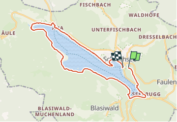
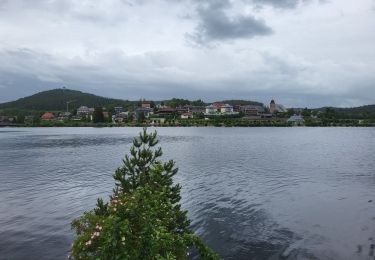
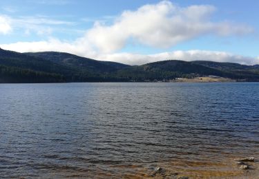
Ruta A pie de 17,5 km a descubrir en Baden-Wurtemberg, Landkreis Breisgau-Hochschwarzwald, Schluchsee. Esta ruta ha sido propuesta por SityTrail - itinéraires balisés pédestres.
Descripción
mehrer Symbole im Wegverlauf
Symbol: gelbe Raute liegend auf weissem Grund
Localización
País:
Germany
Región :
Baden-Wurtemberg
Departamento/provincia :
Landkreis Breisgau-Hochschwarzwald
Municipio :
Schluchsee
Localidad:
Schluchsee (Kernort)
Salida:(Dec)
Salida:(UTM)
438839 ; 5296033 (32T) N.
Comentarios
Excursiones cerca
![Excursión A pie Schluchsee - Aha - Altglashütten - Photo](https://media.geolcdn.com/t/375/260/ext.jpg?maxdim=2&url=https%3A%2F%2Fmedia.geolcdn.com%2Ff%2Ffbef3630-0250-410c-a6a1-80448ac48f09.jpeg)
![A pie A pie](https://static1.geolcdn.com/sitytour/trail-icons/100.png)
Aha - Altglashütten
A pie
Fácil
Schluchsee,
Baden-Wurtemberg,
Landkreis Breisgau-Hochschwarzwald,
Germany
![](/images/other/stat-length.png)
4 km | 5,1 km-effort
1h 9min
![](https://static1.geolcdn.com/siteimages/upload/files/16400158638029165_repeat_loop_refresh_sync_direction_icon.png)
No
![Excursión A pie Schluchsee - Jägersteig - Photo](https://media.geolcdn.com/t/375/260/ext.jpg?maxdim=2&url=https%3A%2F%2Fmedia.geolcdn.com%2Ff%2Fe6618854-799a-4113-a147-f68601b347d5.jpeg)
![A pie A pie](https://static1.geolcdn.com/sitytour/trail-icons/100.png)
Jägersteig
A pie
Fácil
Schluchsee,
Baden-Wurtemberg,
Landkreis Breisgau-Hochschwarzwald,
Germany
![](/images/other/stat-length.png)
11,6 km | 15,8 km-effort
3h 35min
![](https://static1.geolcdn.com/siteimages/upload/files/16400158638029165_repeat_loop_refresh_sync_direction_icon.png)
Sí
![Excursión A pie Schluchsee - DE-Ehemalige Krummensäge - Kohlhütte - fixme - Photo](https://media.geolcdn.com/t/375/260/ext.jpg?maxdim=2&url=https%3A%2F%2Fmedia.geolcdn.com%2Ff%2F00edd11d-5774-4c7d-84eb-be79de7d632d.jpeg)
![A pie A pie](https://static1.geolcdn.com/sitytour/trail-icons/100.png)
DE-Ehemalige Krummensäge - Kohlhütte - fixme
A pie
Fácil
Schluchsee,
Baden-Wurtemberg,
Landkreis Breisgau-Hochschwarzwald,
Germany
![](/images/other/stat-length.png)
3,1 km | 3,6 km-effort
49min
![](https://static1.geolcdn.com/siteimages/upload/files/16400158638029165_repeat_loop_refresh_sync_direction_icon.png)
No
![Excursión Senderismo Schluchsee - Forêt Noire : tour du lac Schluchsee - Photo](https://media.geolcdn.com/t/375/260/ext.jpg?maxdim=2&url=https%3A%2F%2Fmedia.geolcdn.com%2Ff%2F4bd1242a-de17-40e1-bef7-3804b25aa960.jpg)
![Senderismo Senderismo](https://static1.geolcdn.com/sitytour/trail-icons/101.png)
Forêt Noire : tour du lac Schluchsee
Senderismo
Muy difícil
Schluchsee,
Baden-Wurtemberg,
Landkreis Breisgau-Hochschwarzwald,
Germany
![](/images/other/stat-length.png)
17,7 km | 21 km-effort
4h 49min
![](https://static1.geolcdn.com/siteimages/upload/files/16400158638029165_repeat_loop_refresh_sync_direction_icon.png)
Sí
![Excursión A pie Schluchsee - DE-Eselshütte - Muchenland Parkplatz - Photo](https://media.geolcdn.com/t/375/260/ext.jpg?maxdim=2&url=https%3A%2F%2Fstatic1.geolcdn.com%2Fsiteimages%2Fupload%2Ffiles%2F1545311037marcheuse_200dpi.jpg)
![A pie A pie](https://static1.geolcdn.com/sitytour/trail-icons/100.png)
DE-Eselshütte - Muchenland Parkplatz
A pie
Fácil
Schluchsee,
Baden-Wurtemberg,
Landkreis Breisgau-Hochschwarzwald,
Germany
![](/images/other/stat-length.png)
3,1 km | 3,7 km-effort
50min
![](https://static1.geolcdn.com/siteimages/upload/files/16400158638029165_repeat_loop_refresh_sync_direction_icon.png)
No
![Excursión Senderismo Schluchsee - Schluchsee - Photo](https://media.geolcdn.com/t/375/260/ext.jpg?maxdim=2&url=https%3A%2F%2Fmedia.geolcdn.com%2Ff%2Ffd30626f-f2de-4b12-82e2-d6596e2d9d5f.jpg)
![Senderismo Senderismo](https://static1.geolcdn.com/sitytour/trail-icons/101.png)
Schluchsee
Senderismo
Muy fácil
Schluchsee,
Baden-Wurtemberg,
Landkreis Breisgau-Hochschwarzwald,
Germany
![](/images/other/stat-length.png)
5,7 km | 6,5 km-effort
1h 45min
![](https://static1.geolcdn.com/siteimages/upload/files/16400158638029165_repeat_loop_refresh_sync_direction_icon.png)
Sí
![Excursión Senderismo Schluchsee - schluchsee-St blasien - Photo](https://media.geolcdn.com/t/375/260/ext.jpg?maxdim=2&url=https%3A%2F%2Fstatic1.geolcdn.com%2Fsiteimages%2Fupload%2Ffiles%2F1553511878bg_sport_marche.png)
![Senderismo Senderismo](https://static1.geolcdn.com/sitytour/trail-icons/101.png)
schluchsee-St blasien
Senderismo
Muy difícil
Schluchsee,
Baden-Wurtemberg,
Landkreis Breisgau-Hochschwarzwald,
Germany
![](/images/other/stat-length.png)
19,5 km | 27 km-effort
6h 13min
![](https://static1.geolcdn.com/siteimages/upload/files/16400158638029165_repeat_loop_refresh_sync_direction_icon.png)
No
![Excursión Otra actividad Schluchsee - schluchsee - Photo](https://media.geolcdn.com/t/375/260/ext.jpg?maxdim=2&url=https%3A%2F%2Fstatic1.geolcdn.com%2Fsiteimages%2Fupload%2Ffiles%2F1545311037marcheuse_200dpi.jpg)
![Otra actividad Otra actividad](https://static1.geolcdn.com/sitytour/trail-icons/900.png)
schluchsee
Otra actividad
Muy fácil
Schluchsee,
Baden-Wurtemberg,
Landkreis Breisgau-Hochschwarzwald,
Germany
![](/images/other/stat-length.png)
12,5 km | 17,9 km-effort
5h 41min
![](https://static1.geolcdn.com/siteimages/upload/files/16400158638029165_repeat_loop_refresh_sync_direction_icon.png)
No
![Excursión Vía ferrata Schluchsee - 15 Velo um den Schluchsee - Photo](https://media.geolcdn.com/t/375/260/ext.jpg?maxdim=2&url=https%3A%2F%2Fstatic1.geolcdn.com%2Fsiteimages%2Fupload%2Ffiles%2F1545311037marcheuse_200dpi.jpg)
![Vía ferrata Vía ferrata](https://static1.geolcdn.com/sitytour/trail-icons/902.png)
15 Velo um den Schluchsee
Vía ferrata
Muy fácil
Schluchsee,
Baden-Wurtemberg,
Landkreis Breisgau-Hochschwarzwald,
Germany
![](/images/other/stat-length.png)
20 km | 28 km-effort
Desconocido
![](https://static1.geolcdn.com/siteimages/upload/files/16400158638029165_repeat_loop_refresh_sync_direction_icon.png)
Sí