![](/images/other/stat-length.png)
![Excursión A pie Küps - Tüschnitzer Lindenweg - Photo](https://media.geolcdn.com/t/1900/400/c7cbf631-9498-41f9-8d64-efc342baabfc.jpeg&format=pjpeg&maxdim=2)
Tüschnitzer Lindenweg
SityTrail - itinéraires balisés pédestres
Tous les sentiers balisés d’Europe GUIDE+
![Longitud](/images/other/stat-length.png)
Longitud
4,9 km
![Altitud máxima](https://static1.geolcdn.com/siteimages/upload/files/1508320355ic_sort_altitude_max_24dp.png)
Altitud máxima
370 m
![Desnivel positivo](https://static1.geolcdn.com/siteimages/upload/files/1508320355ic_sort_den_pos_24dp.png)
Desnivel positivo
83 m
![Km-Effort](/images/other/stat-length.png)
Km-Effort
6 km
![Altitud mínima](https://static1.geolcdn.com/siteimages/upload/files/1508320355ic_sort_altitude_min_24dp.png)
Altitud mínima
303 m
![Desnivel negativo](https://static1.geolcdn.com/siteimages/upload/files/1508320355ic_sort_den_neg_24dp.png)
Desnivel negativo
80 m
![Boucle](https://static1.geolcdn.com/siteimages/upload/files/16400158638029165_repeat_loop_refresh_sync_direction_icon.png)
Boucle
Sí
Baliza
Fecha de creación :
2022-02-11 19:00:51.431
Última modificación :
2022-02-11 19:00:51.431
![A pie](https://static1.geolcdn.com/sitytour/trail-icons/100.png)
1h21
Dificultad : Fácil
![Escanee este código QR para abrir la excursión en la aplicación SityTrail](https://capi.geolives.com/qq0zvz2zws4bq2lad0pu/sitytour/trails/3100155/qr.png?size=200)
Aplicación GPS de excursión GRATIS
A propósito
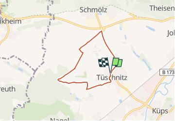
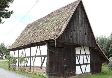
Ruta A pie de 4,9 km a descubrir en Baviera, Landkreis Kronach, Küps. Esta ruta ha sido propuesta por SityTrail - itinéraires balisés pédestres.
Descripción
Auf manchen Wanderkarten auch KC 41, aber keine Markierung
Symbol: Grüner Lindenbaum auf weißem Hintergrund
Localización
País:
Germany
Región :
Baviera
Departamento/provincia :
Landkreis Kronach
Municipio :
Küps
Localidad:
Unknown
Salida:(Dec)
Salida:(UTM)
661300 ; 5563347 (32U) N.
Comentarios
Excursiones cerca
![Excursión A pie Redwitz a.d.Rodach - Trainauer Weg - Photo](https://media.geolcdn.com/t/375/260/c780133a-3ce0-4d7e-bd56-d8344030174b.jpeg&format=jpg&maxdim=2)
![A pie A pie](https://static1.geolcdn.com/sitytour/trail-icons/100.png)
Trainauer Weg
A pie
Fácil
Redwitz a.d.Rodach,
Baviera,
Landkreis Lichtenfels,
Germany
![](/images/other/stat-length.png)
5,8 km | 7,3 km-effort
1h 39min
![](https://static1.geolcdn.com/siteimages/upload/files/16400158638029165_repeat_loop_refresh_sync_direction_icon.png)
No
![Excursión A pie Redwitz a.d.Rodach - Redwitzer Runde - Photo](https://media.geolcdn.com/t/375/260/0a9daf24-74a6-4529-aec9-bc4f74a01100.jpeg&format=jpg&maxdim=2)
![A pie A pie](https://static1.geolcdn.com/sitytour/trail-icons/100.png)
Redwitzer Runde
A pie
Fácil
Redwitz a.d.Rodach,
Baviera,
Landkreis Lichtenfels,
Germany
![](/images/other/stat-length.png)
7,2 km | 9,2 km-effort
2h 5min
![](https://static1.geolcdn.com/siteimages/upload/files/16400158638029165_repeat_loop_refresh_sync_direction_icon.png)
Sí
![Excursión A pie Redwitz a.d.Rodach - Redwitzer Kleeblattrunde - Photo](https://media.geolcdn.com/t/375/260/0a9daf24-74a6-4529-aec9-bc4f74a01100.jpeg&format=jpg&maxdim=2)
![A pie A pie](https://static1.geolcdn.com/sitytour/trail-icons/100.png)
Redwitzer Kleeblattrunde
A pie
Fácil
Redwitz a.d.Rodach,
Baviera,
Landkreis Lichtenfels,
Germany
![](/images/other/stat-length.png)
10,7 km | 14 km-effort
3h 11min
![](https://static1.geolcdn.com/siteimages/upload/files/16400158638029165_repeat_loop_refresh_sync_direction_icon.png)
Sí
![Excursión A pie Redwitz a.d.Rodach - Redwitzer Biotoprunde - Photo](https://media.geolcdn.com/t/375/260/4692316d-4b47-4112-8f39-76a58a3a47c4.jpeg&format=jpg&maxdim=2)
![A pie A pie](https://static1.geolcdn.com/sitytour/trail-icons/100.png)
Redwitzer Biotoprunde
A pie
Fácil
Redwitz a.d.Rodach,
Baviera,
Landkreis Lichtenfels,
Germany
![](/images/other/stat-length.png)
6,5 km | 6,9 km-effort
1h 34min
![](https://static1.geolcdn.com/siteimages/upload/files/16400158638029165_repeat_loop_refresh_sync_direction_icon.png)
Sí
![Excursión A pie Redwitz a.d.Rodach - Frutschbrunnen Runde - Photo](https://media.geolcdn.com/t/375/260/0a9daf24-74a6-4529-aec9-bc4f74a01100.jpeg&format=jpg&maxdim=2)
![A pie A pie](https://static1.geolcdn.com/sitytour/trail-icons/100.png)
Frutschbrunnen Runde
A pie
Fácil
Redwitz a.d.Rodach,
Baviera,
Landkreis Lichtenfels,
Germany
![](/images/other/stat-length.png)
8,1 km | 10,5 km-effort
2h 23min
![](https://static1.geolcdn.com/siteimages/upload/files/16400158638029165_repeat_loop_refresh_sync_direction_icon.png)
Sí
![Excursión A pie Burgkunstadt - Felsensteig - Photo](https://media.geolcdn.com/t/375/260/220640e8-8155-4f3d-ba73-c9277146149e.jpeg&format=jpg&maxdim=2)
![A pie A pie](https://static1.geolcdn.com/sitytour/trail-icons/100.png)
Felsensteig
A pie
Fácil
Burgkunstadt,
Baviera,
Landkreis Lichtenfels,
Germany
![](/images/other/stat-length.png)
6,9 km | 8,4 km-effort
1h 54min
![](https://static1.geolcdn.com/siteimages/upload/files/16400158638029165_repeat_loop_refresh_sync_direction_icon.png)
Sí
![Excursión A pie Redwitz a.d.Rodach - Hochstadter Rundweg - Photo](https://media.geolcdn.com/t/375/260/90c1ed2d-a47d-41b7-b9c7-edf3f904247f.jpeg&format=jpg&maxdim=2)
![A pie A pie](https://static1.geolcdn.com/sitytour/trail-icons/100.png)
Hochstadter Rundweg
A pie
Fácil
Redwitz a.d.Rodach,
Baviera,
Landkreis Lichtenfels,
Germany
![](/images/other/stat-length.png)
14 km | 16,6 km-effort
3h 46min
![](https://static1.geolcdn.com/siteimages/upload/files/16400158638029165_repeat_loop_refresh_sync_direction_icon.png)
Sí
![Excursión A pie Burgkunstadt - Sonnenweg - Photo](https://media.geolcdn.com/t/375/260/cfb5c786-9637-42e5-8f06-775d37b94326.jpeg&format=jpg&maxdim=2)
![A pie A pie](https://static1.geolcdn.com/sitytour/trail-icons/100.png)
Sonnenweg
A pie
Fácil
Burgkunstadt,
Baviera,
Landkreis Lichtenfels,
Germany
![](/images/other/stat-length.png)
5 km | 6 km-effort
1h 22min
![](https://static1.geolcdn.com/siteimages/upload/files/16400158638029165_repeat_loop_refresh_sync_direction_icon.png)
Sí
![Excursión A pie Küps - Sieben-Fuhren-Weg - Photo](https://media.geolcdn.com/t/375/260/2bddbc66-080d-4c30-9b56-b3a29b790c54.jpeg&format=jpg&maxdim=2)
![A pie A pie](https://static1.geolcdn.com/sitytour/trail-icons/100.png)
Sieben-Fuhren-Weg
A pie
Fácil
Küps,
Baviera,
Landkreis Kronach,
Germany
![](/images/other/stat-length.png)
7,7 km | 10,3 km-effort
2h 20min
![](https://static1.geolcdn.com/siteimages/upload/files/16400158638029165_repeat_loop_refresh_sync_direction_icon.png)
Sí