![](/images/other/stat-length.png)
![Excursión A pie Hümmerich - Butterpfad - Photo](https://media.geolcdn.com/t/1900/400/ext.pjpeg?maxdim=2&url=https%3A%2F%2Fmedia.geolcdn.com%2Ff%2F53665152-448a-4296-9aeb-c73b4f68d052.jpeg)
Butterpfad
SityTrail - itinéraires balisés pédestres
Tous les sentiers balisés d’Europe PRO
![Longitud](/images/other/stat-length.png)
Longitud
10,7 km
![Altitud máxima](https://static1.geolcdn.com/siteimages/upload/files/1508320355ic_sort_altitude_max_24dp.png)
Altitud máxima
396 m
![Desnivel positivo](https://static1.geolcdn.com/siteimages/upload/files/1508320355ic_sort_den_pos_24dp.png)
Desnivel positivo
217 m
![Km-Effort](/images/other/stat-length.png)
Km-Effort
13,9 km
![Altitud mínima](https://static1.geolcdn.com/siteimages/upload/files/1508320355ic_sort_altitude_min_24dp.png)
Altitud mínima
251 m
![Desnivel negativo](https://static1.geolcdn.com/siteimages/upload/files/1508320355ic_sort_den_neg_24dp.png)
Desnivel negativo
302 m
![Boucle](https://static1.geolcdn.com/siteimages/upload/files/16400158638029165_repeat_loop_refresh_sync_direction_icon.png)
Boucle
No
Baliza
Fecha de creación :
2022-02-11 18:59:01.052
Última modificación :
2022-02-11 18:59:01.052
![A pie](https://static1.geolcdn.com/sitytour/trail-icons/100.png)
3h09
Dificultad : Fácil
![Escanee este código QR para abrir la excursión en la aplicación SityTrail](https://capi.geolives.com/qq0zvz2zws4bq2lad0pu/sitytour/trails/3100121/qr.png?size=200)
Aplicación GPS de excursión GRATIS
A propósito
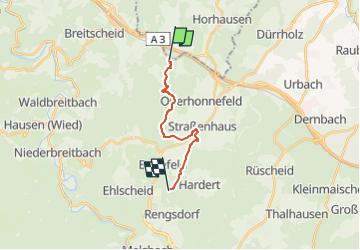
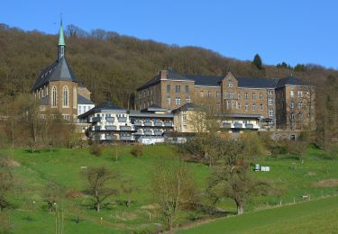
Ruta A pie de 10,7 km a descubrir en Renania-Palatinado, Landkreis Neuwied, Hümmerich. Esta ruta ha sido propuesta por SityTrail - itinéraires balisés pédestres.
Descripción
Symbol: Weißer Schriftzug "Butterpfad" auf rotem, recheckigen Grund
Localización
País:
Germany
Región :
Renania-Palatinado
Departamento/provincia :
Landkreis Neuwied
Municipio :
Hümmerich
Localidad:
Unknown
Salida:(Dec)
Salida:(UTM)
393394 ; 5603125 (32U) N.
Comentarios
Excursiones cerca
![Excursión A pie Oberhonnefeld-Gierend - Rundwanderweg Oberhobnnefeld 1 - Photo](https://media.geolcdn.com/t/375/260/ext.jpg?maxdim=2&url=https%3A%2F%2Fmedia.geolcdn.com%2Ff%2F2d677b68-54b9-424c-a1b5-5e7f7ae4617d.jpeg)
![A pie A pie](https://static1.geolcdn.com/sitytour/trail-icons/100.png)
Rundwanderweg Oberhobnnefeld 1
A pie
Fácil
Oberhonnefeld-Gierend,
Renania-Palatinado,
Landkreis Neuwied,
Germany
![](/images/other/stat-length.png)
3,4 km | 4,3 km-effort
58min
![](https://static1.geolcdn.com/siteimages/upload/files/16400158638029165_repeat_loop_refresh_sync_direction_icon.png)
Sí
![Excursión A pie Oberhonnefeld-Gierend - Rundwanderweg Gierend 1 - Photo](https://media.geolcdn.com/t/375/260/ext.jpg?maxdim=2&url=https%3A%2F%2Fmedia.geolcdn.com%2Ff%2F2d677b68-54b9-424c-a1b5-5e7f7ae4617d.jpeg)
![A pie A pie](https://static1.geolcdn.com/sitytour/trail-icons/100.png)
Rundwanderweg Gierend 1
A pie
Fácil
Oberhonnefeld-Gierend,
Renania-Palatinado,
Landkreis Neuwied,
Germany
![](/images/other/stat-length.png)
7,8 km | 9,9 km-effort
2h 14min
![](https://static1.geolcdn.com/siteimages/upload/files/16400158638029165_repeat_loop_refresh_sync_direction_icon.png)
Sí
![Excursión A pie Breitscheid - Rundwanderweg Roßbach 1 - Photo](https://media.geolcdn.com/t/375/260/ext.jpg?maxdim=2&url=https%3A%2F%2Fmedia.geolcdn.com%2Ff%2Ff2c11825-d560-4b0a-bc8e-3db9a2b40c70.jpeg)
![A pie A pie](https://static1.geolcdn.com/sitytour/trail-icons/100.png)
Rundwanderweg Roßbach 1
A pie
Medio
Breitscheid,
Renania-Palatinado,
Landkreis Neuwied,
Germany
![](/images/other/stat-length.png)
17,5 km | 25 km-effort
5h 44min
![](https://static1.geolcdn.com/siteimages/upload/files/16400158638029165_repeat_loop_refresh_sync_direction_icon.png)
Sí
![Excursión A pie Waldbreitbach - Wäller Tour Bärenkopp - Photo](https://media.geolcdn.com/t/375/260/ext.jpg?maxdim=2&url=https%3A%2F%2Fmedia.geolcdn.com%2Ff%2F238fc8e7-6c8b-4adb-b83b-2a3fb088db7a.jpeg)
![A pie A pie](https://static1.geolcdn.com/sitytour/trail-icons/100.png)
Wäller Tour Bärenkopp
A pie
Fácil
Waldbreitbach,
Renania-Palatinado,
Landkreis Neuwied,
Germany
![](/images/other/stat-length.png)
11,5 km | 16,2 km-effort
3h 40min
![](https://static1.geolcdn.com/siteimages/upload/files/16400158638029165_repeat_loop_refresh_sync_direction_icon.png)
Sí
![Excursión A pie Straßenhaus - Rundwanderweg Straßenhaus 3 - Photo](https://media.geolcdn.com/t/375/260/ext.jpg?maxdim=2&url=https%3A%2F%2Fmedia.geolcdn.com%2Ff%2Fd9876f59-7d83-439a-b3ec-7b0995064150.jpeg)
![A pie A pie](https://static1.geolcdn.com/sitytour/trail-icons/100.png)
Rundwanderweg Straßenhaus 3
A pie
Fácil
Straßenhaus,
Renania-Palatinado,
Landkreis Neuwied,
Germany
![](/images/other/stat-length.png)
3,6 km | 4,3 km-effort
58min
![](https://static1.geolcdn.com/siteimages/upload/files/16400158638029165_repeat_loop_refresh_sync_direction_icon.png)
No
![Excursión A pie Neustadt (Wied) - [N1] Bertenauer Weg - Photo](https://media.geolcdn.com/t/375/260/ext.jpg?maxdim=2&url=https%3A%2F%2Fmedia.geolcdn.com%2Ff%2F23673f5b-8e9e-4aac-bd57-d7ced4e8cded.jpeg)
![A pie A pie](https://static1.geolcdn.com/sitytour/trail-icons/100.png)
[N1] Bertenauer Weg
A pie
Medio
Neustadt (Wied),
Renania-Palatinado,
Landkreis Neuwied,
Germany
![](/images/other/stat-length.png)
17,6 km | 24 km-effort
5h 23min
![](https://static1.geolcdn.com/siteimages/upload/files/16400158638029165_repeat_loop_refresh_sync_direction_icon.png)
Sí
![Excursión A pie Oberraden - Rundwanderweg Oberraden 2 - Photo](https://media.geolcdn.com/t/375/260/ext.jpg?maxdim=2&url=https%3A%2F%2Fmedia.geolcdn.com%2Ff%2F7189a7ae-80e4-4b82-aee0-d2fb0ac6e4f6.jpeg)
![A pie A pie](https://static1.geolcdn.com/sitytour/trail-icons/100.png)
Rundwanderweg Oberraden 2
A pie
Fácil
Oberraden,
Renania-Palatinado,
Landkreis Neuwied,
Germany
![](/images/other/stat-length.png)
4 km | 5 km-effort
1h 8min
![](https://static1.geolcdn.com/siteimages/upload/files/16400158638029165_repeat_loop_refresh_sync_direction_icon.png)
Sí
![Excursión A pie Oberraden - Rundwanderweg Oberraden 1 - Photo](https://media.geolcdn.com/t/375/260/ext.jpg?maxdim=2&url=https%3A%2F%2Fmedia.geolcdn.com%2Ff%2F2d677b68-54b9-424c-a1b5-5e7f7ae4617d.jpeg)
![A pie A pie](https://static1.geolcdn.com/sitytour/trail-icons/100.png)
Rundwanderweg Oberraden 1
A pie
Fácil
Oberraden,
Renania-Palatinado,
Landkreis Neuwied,
Germany
![](/images/other/stat-length.png)
6,6 km | 8,7 km-effort
1h 58min
![](https://static1.geolcdn.com/siteimages/upload/files/16400158638029165_repeat_loop_refresh_sync_direction_icon.png)
Sí
![Excursión A pie Oberraden - Rundwanderweg Niederraden 1 - Photo](https://media.geolcdn.com/t/375/260/ext.jpg?maxdim=2&url=https%3A%2F%2Fstatic1.geolcdn.com%2Fsiteimages%2Fupload%2Ffiles%2F1545311037marcheuse_200dpi.jpg)
![A pie A pie](https://static1.geolcdn.com/sitytour/trail-icons/100.png)
Rundwanderweg Niederraden 1
A pie
Fácil
Oberraden,
Renania-Palatinado,
Landkreis Neuwied,
Germany
![](/images/other/stat-length.png)
5,6 km | 7,1 km-effort
1h 37min
![](https://static1.geolcdn.com/siteimages/upload/files/16400158638029165_repeat_loop_refresh_sync_direction_icon.png)
Sí