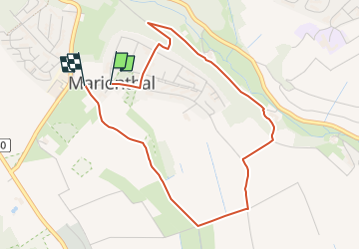
![](/images/other/stat-length.png)
![Excursión A pie Geisenheim - Geisenheimer Rundweg F - Photo](https://media.geolcdn.com/t/1900/400/c4e2e677-d8d1-4f54-8616-f5083e0a1cdf.jpeg&format=pjpeg&maxdim=2)
Geisenheimer Rundweg F
SityTrail - itinéraires balisés pédestres
Tous les sentiers balisés d’Europe GUIDE+
![Longitud](/images/other/stat-length.png)
![Altitud máxima](https://static1.geolcdn.com/siteimages/upload/files/1508320355ic_sort_altitude_max_24dp.png)
![Desnivel positivo](https://static1.geolcdn.com/siteimages/upload/files/1508320355ic_sort_den_pos_24dp.png)
![Km-Effort](/images/other/stat-length.png)
![Altitud mínima](https://static1.geolcdn.com/siteimages/upload/files/1508320355ic_sort_altitude_min_24dp.png)
![Desnivel negativo](https://static1.geolcdn.com/siteimages/upload/files/1508320355ic_sort_den_neg_24dp.png)
![Boucle](https://static1.geolcdn.com/siteimages/upload/files/16400158638029165_repeat_loop_refresh_sync_direction_icon.png)
![A pie](https://static1.geolcdn.com/sitytour/trail-icons/100.png)
1h09
Dificultad : Fácil
![Escanee este código QR para abrir la excursión en la aplicación SityTrail](https://capi.geolives.com/qq0zvz2zws4bq2lad0pu/sitytour/trails/3100113/qr.png?size=200)
Aplicación GPS de excursión GRATIS
A propósito
Ruta A pie de 3,9 km a descubrir en Hesse, Rheingau-Taunus-Kreis, Geisenheim. Esta ruta ha sido propuesta por SityTrail - itinéraires balisés pédestres.
Descripción
Trail created by Stadt Geisenheim.
Symbol: Weißes Schild, oben in schwarz stilisierte Kirche hinter Baum und Rebe, darunter in schwarz "Rundweg", darunter horizontale Linie, darunter in rot links ein Pfeil nach rechts, anschließend "F 5 km"
Localización
Comentarios
Excursiones cerca
![Excursión A pie Geisenheim - Himmelssteig Stephanshausen - Photo](https://media.geolcdn.com/t/375/260/9223db67-e7da-4277-bf63-0b96616ead54.jpeg&format=jpg&maxdim=2)
![A pie A pie](https://static1.geolcdn.com/sitytour/trail-icons/100.png)
A pie
![](/images/other/stat-length.png)
![](https://static1.geolcdn.com/siteimages/upload/files/16400158638029165_repeat_loop_refresh_sync_direction_icon.png)
![Excursión A pie Geisenheim - Geisenheimer Rundweg O - Photo](https://media.geolcdn.com/t/375/260/23caf65e-d1b0-432b-8cb1-95d45052c5b3.jpeg&format=jpg&maxdim=2)
![A pie A pie](https://static1.geolcdn.com/sitytour/trail-icons/100.png)
A pie
![](/images/other/stat-length.png)
![](https://static1.geolcdn.com/siteimages/upload/files/16400158638029165_repeat_loop_refresh_sync_direction_icon.png)
![Excursión A pie Geisenheim - Geisenheimer Rundweg M - Photo](https://media.geolcdn.com/t/375/260/0aad0740-e5ea-4eab-b9e4-1dc6f9e6e635.jpeg&format=jpg&maxdim=2)
![A pie A pie](https://static1.geolcdn.com/sitytour/trail-icons/100.png)
A pie
![](/images/other/stat-length.png)
![](https://static1.geolcdn.com/siteimages/upload/files/16400158638029165_repeat_loop_refresh_sync_direction_icon.png)
![Excursión A pie Geisenheim - Geisenheimer Rundweg I - Photo](https://media.geolcdn.com/t/375/260/a7b95e33-3a2b-44fc-8c9b-988116704fbb.jpeg&format=jpg&maxdim=2)
![A pie A pie](https://static1.geolcdn.com/sitytour/trail-icons/100.png)
A pie
![](/images/other/stat-length.png)
![](https://static1.geolcdn.com/siteimages/upload/files/16400158638029165_repeat_loop_refresh_sync_direction_icon.png)
![Excursión A pie Geisenheim - Geisenheimer Rundweg J - Photo](https://media.geolcdn.com/t/375/260/e4502c24-35a9-4c74-a651-9299cfecf071.jpeg&format=jpg&maxdim=2)
![A pie A pie](https://static1.geolcdn.com/sitytour/trail-icons/100.png)
A pie
![](/images/other/stat-length.png)
![](https://static1.geolcdn.com/siteimages/upload/files/16400158638029165_repeat_loop_refresh_sync_direction_icon.png)
![Excursión A pie Geisenheim - Geisenheimer Rundweg D - Photo](https://media.geolcdn.com/t/375/260/9223db67-e7da-4277-bf63-0b96616ead54.jpeg&format=jpg&maxdim=2)
![A pie A pie](https://static1.geolcdn.com/sitytour/trail-icons/100.png)
A pie
![](/images/other/stat-length.png)
![](https://static1.geolcdn.com/siteimages/upload/files/16400158638029165_repeat_loop_refresh_sync_direction_icon.png)
![Excursión A pie Oestrich-Winkel - Mühlenwanderweg im Elsterbachtal - Photo](https://media.geolcdn.com/t/375/260/e4502c24-35a9-4c74-a651-9299cfecf071.jpeg&format=jpg&maxdim=2)
![A pie A pie](https://static1.geolcdn.com/sitytour/trail-icons/100.png)
A pie
![](/images/other/stat-length.png)
![](https://static1.geolcdn.com/siteimages/upload/files/16400158638029165_repeat_loop_refresh_sync_direction_icon.png)
![Excursión A pie Geisenheim - Geisenheimer Rundweg L - Photo](https://media.geolcdn.com/t/375/260/f6a6296f-73fa-467e-a544-97556f064c77.jpeg&format=jpg&maxdim=2)
![A pie A pie](https://static1.geolcdn.com/sitytour/trail-icons/100.png)
A pie
![](/images/other/stat-length.png)
![](https://static1.geolcdn.com/siteimages/upload/files/16400158638029165_repeat_loop_refresh_sync_direction_icon.png)
![Excursión A pie Geisenheim - Geisenheimer Rundweg G - Photo](https://media.geolcdn.com/t/375/260/9abb1e74-7c9e-46bf-b27f-b13dbf93b1b6.jpeg&format=jpg&maxdim=2)
![A pie A pie](https://static1.geolcdn.com/sitytour/trail-icons/100.png)
A pie
![](/images/other/stat-length.png)
![](https://static1.geolcdn.com/siteimages/upload/files/16400158638029165_repeat_loop_refresh_sync_direction_icon.png)