


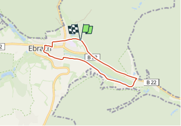

3,7 km | 4,7 km-effort

Tous les sentiers balisés d’Europe GUIDE+


Aplicación GPS de excursión GRATIS
 SityTrail
IGN / Institutos geográficos
SityTrail World
El mundo es suyo
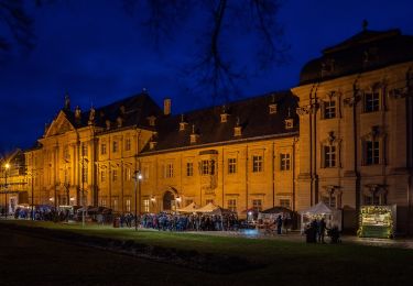
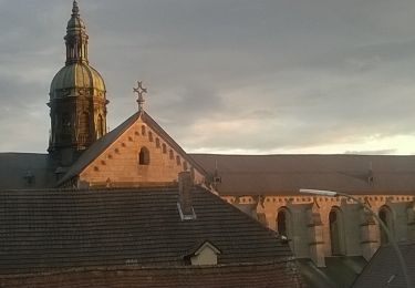
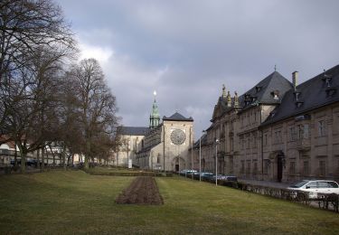
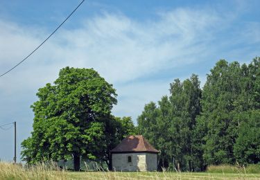
Ruta A pie de 5,6 km a descubrir en Baviera, Landkreis Bamberg, Ebrach. Esta ruta ha sido propuesta por SityTrail - itinéraires balisés pédestres.
Symbol: Schwarze E 11 auf gelbem Hintergrund
 "
data-pinterest-text="Pin it"
data-tweet-text="share on twitter"
data-facebook-share-url="https://www.sitytrail.com/es/trails/3100044-ebrach--rundweg-xeberaux/?photo=1#lg=1&slide=1"
data-twitter-share-url="https://www.sitytrail.com/es/trails/3100044-ebrach--rundweg-xeberaux/?photo=1#lg=1&slide=1"
data-googleplus-share-url="https://www.sitytrail.com/es/trails/3100044-ebrach--rundweg-xeberaux/?photo=1#lg=1&slide=1"
data-pinterest-share-url="https://www.sitytrail.com/es/trails/3100044-ebrach--rundweg-xeberaux/?photo=1#lg=1&slide=1">
"
data-pinterest-text="Pin it"
data-tweet-text="share on twitter"
data-facebook-share-url="https://www.sitytrail.com/es/trails/3100044-ebrach--rundweg-xeberaux/?photo=1#lg=1&slide=1"
data-twitter-share-url="https://www.sitytrail.com/es/trails/3100044-ebrach--rundweg-xeberaux/?photo=1#lg=1&slide=1"
data-googleplus-share-url="https://www.sitytrail.com/es/trails/3100044-ebrach--rundweg-xeberaux/?photo=1#lg=1&slide=1"
data-pinterest-share-url="https://www.sitytrail.com/es/trails/3100044-ebrach--rundweg-xeberaux/?photo=1#lg=1&slide=1">
 "
data-pinterest-text="Pin it"
data-tweet-text="share on twitter"
data-facebook-share-url="https://www.sitytrail.com/es/trails/3100044-ebrach--rundweg-xeberaux/?photo=2#lg=1&slide=2"
data-twitter-share-url="https://www.sitytrail.com/es/trails/3100044-ebrach--rundweg-xeberaux/?photo=2#lg=1&slide=2"
data-googleplus-share-url="https://www.sitytrail.com/es/trails/3100044-ebrach--rundweg-xeberaux/?photo=2#lg=1&slide=2"
data-pinterest-share-url="https://www.sitytrail.com/es/trails/3100044-ebrach--rundweg-xeberaux/?photo=2#lg=1&slide=2">
"
data-pinterest-text="Pin it"
data-tweet-text="share on twitter"
data-facebook-share-url="https://www.sitytrail.com/es/trails/3100044-ebrach--rundweg-xeberaux/?photo=2#lg=1&slide=2"
data-twitter-share-url="https://www.sitytrail.com/es/trails/3100044-ebrach--rundweg-xeberaux/?photo=2#lg=1&slide=2"
data-googleplus-share-url="https://www.sitytrail.com/es/trails/3100044-ebrach--rundweg-xeberaux/?photo=2#lg=1&slide=2"
data-pinterest-share-url="https://www.sitytrail.com/es/trails/3100044-ebrach--rundweg-xeberaux/?photo=2#lg=1&slide=2">
 "
data-pinterest-text="Pin it"
data-tweet-text="share on twitter"
data-facebook-share-url="https://www.sitytrail.com/es/trails/3100044-ebrach--rundweg-xeberaux/?photo=3#lg=1&slide=3"
data-twitter-share-url="https://www.sitytrail.com/es/trails/3100044-ebrach--rundweg-xeberaux/?photo=3#lg=1&slide=3"
data-googleplus-share-url="https://www.sitytrail.com/es/trails/3100044-ebrach--rundweg-xeberaux/?photo=3#lg=1&slide=3"
data-pinterest-share-url="https://www.sitytrail.com/es/trails/3100044-ebrach--rundweg-xeberaux/?photo=3#lg=1&slide=3">
"
data-pinterest-text="Pin it"
data-tweet-text="share on twitter"
data-facebook-share-url="https://www.sitytrail.com/es/trails/3100044-ebrach--rundweg-xeberaux/?photo=3#lg=1&slide=3"
data-twitter-share-url="https://www.sitytrail.com/es/trails/3100044-ebrach--rundweg-xeberaux/?photo=3#lg=1&slide=3"
data-googleplus-share-url="https://www.sitytrail.com/es/trails/3100044-ebrach--rundweg-xeberaux/?photo=3#lg=1&slide=3"
data-pinterest-share-url="https://www.sitytrail.com/es/trails/3100044-ebrach--rundweg-xeberaux/?photo=3#lg=1&slide=3">
 "
data-pinterest-text="Pin it"
data-tweet-text="share on twitter"
data-facebook-share-url="https://www.sitytrail.com/es/trails/3100044-ebrach--rundweg-xeberaux/?photo=4#lg=1&slide=4"
data-twitter-share-url="https://www.sitytrail.com/es/trails/3100044-ebrach--rundweg-xeberaux/?photo=4#lg=1&slide=4"
data-googleplus-share-url="https://www.sitytrail.com/es/trails/3100044-ebrach--rundweg-xeberaux/?photo=4#lg=1&slide=4"
data-pinterest-share-url="https://www.sitytrail.com/es/trails/3100044-ebrach--rundweg-xeberaux/?photo=4#lg=1&slide=4">
"
data-pinterest-text="Pin it"
data-tweet-text="share on twitter"
data-facebook-share-url="https://www.sitytrail.com/es/trails/3100044-ebrach--rundweg-xeberaux/?photo=4#lg=1&slide=4"
data-twitter-share-url="https://www.sitytrail.com/es/trails/3100044-ebrach--rundweg-xeberaux/?photo=4#lg=1&slide=4"
data-googleplus-share-url="https://www.sitytrail.com/es/trails/3100044-ebrach--rundweg-xeberaux/?photo=4#lg=1&slide=4"
data-pinterest-share-url="https://www.sitytrail.com/es/trails/3100044-ebrach--rundweg-xeberaux/?photo=4#lg=1&slide=4">
 "
data-pinterest-text="Pin it"
data-tweet-text="share on twitter"
data-facebook-share-url="https://www.sitytrail.com/es/trails/3100044-ebrach--rundweg-xeberaux/?photo=5#lg=1&slide=5"
data-twitter-share-url="https://www.sitytrail.com/es/trails/3100044-ebrach--rundweg-xeberaux/?photo=5#lg=1&slide=5"
data-googleplus-share-url="https://www.sitytrail.com/es/trails/3100044-ebrach--rundweg-xeberaux/?photo=5#lg=1&slide=5"
data-pinterest-share-url="https://www.sitytrail.com/es/trails/3100044-ebrach--rundweg-xeberaux/?photo=5#lg=1&slide=5">
"
data-pinterest-text="Pin it"
data-tweet-text="share on twitter"
data-facebook-share-url="https://www.sitytrail.com/es/trails/3100044-ebrach--rundweg-xeberaux/?photo=5#lg=1&slide=5"
data-twitter-share-url="https://www.sitytrail.com/es/trails/3100044-ebrach--rundweg-xeberaux/?photo=5#lg=1&slide=5"
data-googleplus-share-url="https://www.sitytrail.com/es/trails/3100044-ebrach--rundweg-xeberaux/?photo=5#lg=1&slide=5"
data-pinterest-share-url="https://www.sitytrail.com/es/trails/3100044-ebrach--rundweg-xeberaux/?photo=5#lg=1&slide=5">
 "
data-pinterest-text="Pin it"
data-tweet-text="share on twitter"
data-facebook-share-url="https://www.sitytrail.com/es/trails/3100044-ebrach--rundweg-xeberaux/?photo=6#lg=1&slide=6"
data-twitter-share-url="https://www.sitytrail.com/es/trails/3100044-ebrach--rundweg-xeberaux/?photo=6#lg=1&slide=6"
data-googleplus-share-url="https://www.sitytrail.com/es/trails/3100044-ebrach--rundweg-xeberaux/?photo=6#lg=1&slide=6"
data-pinterest-share-url="https://www.sitytrail.com/es/trails/3100044-ebrach--rundweg-xeberaux/?photo=6#lg=1&slide=6">
"
data-pinterest-text="Pin it"
data-tweet-text="share on twitter"
data-facebook-share-url="https://www.sitytrail.com/es/trails/3100044-ebrach--rundweg-xeberaux/?photo=6#lg=1&slide=6"
data-twitter-share-url="https://www.sitytrail.com/es/trails/3100044-ebrach--rundweg-xeberaux/?photo=6#lg=1&slide=6"
data-googleplus-share-url="https://www.sitytrail.com/es/trails/3100044-ebrach--rundweg-xeberaux/?photo=6#lg=1&slide=6"
data-pinterest-share-url="https://www.sitytrail.com/es/trails/3100044-ebrach--rundweg-xeberaux/?photo=6#lg=1&slide=6">
 "
data-pinterest-text="Pin it"
data-tweet-text="share on twitter"
data-facebook-share-url="https://www.sitytrail.com/es/trails/3100044-ebrach--rundweg-xeberaux/?photo=7#lg=1&slide=7"
data-twitter-share-url="https://www.sitytrail.com/es/trails/3100044-ebrach--rundweg-xeberaux/?photo=7#lg=1&slide=7"
data-googleplus-share-url="https://www.sitytrail.com/es/trails/3100044-ebrach--rundweg-xeberaux/?photo=7#lg=1&slide=7"
data-pinterest-share-url="https://www.sitytrail.com/es/trails/3100044-ebrach--rundweg-xeberaux/?photo=7#lg=1&slide=7">
"
data-pinterest-text="Pin it"
data-tweet-text="share on twitter"
data-facebook-share-url="https://www.sitytrail.com/es/trails/3100044-ebrach--rundweg-xeberaux/?photo=7#lg=1&slide=7"
data-twitter-share-url="https://www.sitytrail.com/es/trails/3100044-ebrach--rundweg-xeberaux/?photo=7#lg=1&slide=7"
data-googleplus-share-url="https://www.sitytrail.com/es/trails/3100044-ebrach--rundweg-xeberaux/?photo=7#lg=1&slide=7"
data-pinterest-share-url="https://www.sitytrail.com/es/trails/3100044-ebrach--rundweg-xeberaux/?photo=7#lg=1&slide=7">
 "
data-pinterest-text="Pin it"
data-tweet-text="share on twitter"
data-facebook-share-url="https://www.sitytrail.com/es/trails/3100044-ebrach--rundweg-xeberaux/?photo=8#lg=1&slide=8"
data-twitter-share-url="https://www.sitytrail.com/es/trails/3100044-ebrach--rundweg-xeberaux/?photo=8#lg=1&slide=8"
data-googleplus-share-url="https://www.sitytrail.com/es/trails/3100044-ebrach--rundweg-xeberaux/?photo=8#lg=1&slide=8"
data-pinterest-share-url="https://www.sitytrail.com/es/trails/3100044-ebrach--rundweg-xeberaux/?photo=8#lg=1&slide=8">
"
data-pinterest-text="Pin it"
data-tweet-text="share on twitter"
data-facebook-share-url="https://www.sitytrail.com/es/trails/3100044-ebrach--rundweg-xeberaux/?photo=8#lg=1&slide=8"
data-twitter-share-url="https://www.sitytrail.com/es/trails/3100044-ebrach--rundweg-xeberaux/?photo=8#lg=1&slide=8"
data-googleplus-share-url="https://www.sitytrail.com/es/trails/3100044-ebrach--rundweg-xeberaux/?photo=8#lg=1&slide=8"
data-pinterest-share-url="https://www.sitytrail.com/es/trails/3100044-ebrach--rundweg-xeberaux/?photo=8#lg=1&slide=8">
 "
data-pinterest-text="Pin it"
data-tweet-text="share on twitter"
data-facebook-share-url="https://www.sitytrail.com/es/trails/3100044-ebrach--rundweg-xeberaux/?photo=9#lg=1&slide=9"
data-twitter-share-url="https://www.sitytrail.com/es/trails/3100044-ebrach--rundweg-xeberaux/?photo=9#lg=1&slide=9"
data-googleplus-share-url="https://www.sitytrail.com/es/trails/3100044-ebrach--rundweg-xeberaux/?photo=9#lg=1&slide=9"
data-pinterest-share-url="https://www.sitytrail.com/es/trails/3100044-ebrach--rundweg-xeberaux/?photo=9#lg=1&slide=9">
"
data-pinterest-text="Pin it"
data-tweet-text="share on twitter"
data-facebook-share-url="https://www.sitytrail.com/es/trails/3100044-ebrach--rundweg-xeberaux/?photo=9#lg=1&slide=9"
data-twitter-share-url="https://www.sitytrail.com/es/trails/3100044-ebrach--rundweg-xeberaux/?photo=9#lg=1&slide=9"
data-googleplus-share-url="https://www.sitytrail.com/es/trails/3100044-ebrach--rundweg-xeberaux/?photo=9#lg=1&slide=9"
data-pinterest-share-url="https://www.sitytrail.com/es/trails/3100044-ebrach--rundweg-xeberaux/?photo=9#lg=1&slide=9">

A pie
A pie
A pie
A pie
A pie
A pie
A pie
A pie
A pie