![](/images/other/stat-length.png)
![Excursión A pie Buchholz (Westerwald) - [B2] Dreiherrensteinweg - Photo](https://media.geolcdn.com/t/1900/400/aecd4644-6921-4b4a-8659-a9cc70680b9b.jpeg&format=pjpeg&maxdim=2)
[B2] Dreiherrensteinweg
SityTrail - itinéraires balisés pédestres
Tous les sentiers balisés d’Europe GUIDE+
![Longitud](/images/other/stat-length.png)
![Altitud máxima](https://static1.geolcdn.com/siteimages/upload/files/1508320355ic_sort_altitude_max_24dp.png)
![Desnivel positivo](https://static1.geolcdn.com/siteimages/upload/files/1508320355ic_sort_den_pos_24dp.png)
![Km-Effort](/images/other/stat-length.png)
![Altitud mínima](https://static1.geolcdn.com/siteimages/upload/files/1508320355ic_sort_altitude_min_24dp.png)
![Desnivel negativo](https://static1.geolcdn.com/siteimages/upload/files/1508320355ic_sort_den_neg_24dp.png)
![Boucle](https://static1.geolcdn.com/siteimages/upload/files/16400158638029165_repeat_loop_refresh_sync_direction_icon.png)
![A pie](https://static1.geolcdn.com/sitytour/trail-icons/100.png)
3h22
Dificultad : Fácil
![Escanee este código QR para abrir la excursión en la aplicación SityTrail](https://capi.geolives.com/qq0zvz2zws4bq2lad0pu/sitytour/trails/3099726/qr.png?size=200)
Aplicación GPS de excursión GRATIS
A propósito
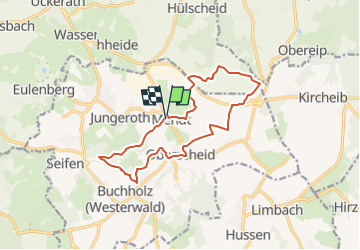
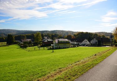
Ruta A pie de 12,4 km a descubrir en Renania-Palatinado, Landkreis Neuwied, Buchholz (Westerwald). Esta ruta ha sido propuesta por SityTrail - itinéraires balisés pédestres.
Descripción
Trail created by Verbandsgemeinde Asbach.
Symbol: weißer Text B2 auf rotem Grund
Sitio web: http://www.wanderwegweiser.de/cms2/index.php/wanderwege-asb/steckbriefe-asb/b2-asb
Localización
Comentarios
Excursiones cerca
![Excursión A pie Asbach - [A4] Mühlenweg - Photo](https://media.geolcdn.com/t/375/260/17f9fb3a-b4a7-45d7-a2b4-ea773ee9f1e5.jpeg&format=jpg&maxdim=2)
![A pie A pie](https://static1.geolcdn.com/sitytour/trail-icons/100.png)
A pie
![](/images/other/stat-length.png)
![](https://static1.geolcdn.com/siteimages/upload/files/16400158638029165_repeat_loop_refresh_sync_direction_icon.png)
![Excursión A pie Asbach - [A3] Kirchspielweg - Photo](https://media.geolcdn.com/t/375/260/17f9fb3a-b4a7-45d7-a2b4-ea773ee9f1e5.jpeg&format=jpg&maxdim=2)
![A pie A pie](https://static1.geolcdn.com/sitytour/trail-icons/100.png)
A pie
![](/images/other/stat-length.png)
![](https://static1.geolcdn.com/siteimages/upload/files/16400158638029165_repeat_loop_refresh_sync_direction_icon.png)
![Excursión A pie Asbach - [A1] Basaltweg - Photo](https://media.geolcdn.com/t/375/260/17f9fb3a-b4a7-45d7-a2b4-ea773ee9f1e5.jpeg&format=jpg&maxdim=2)
![A pie A pie](https://static1.geolcdn.com/sitytour/trail-icons/100.png)
A pie
![](/images/other/stat-length.png)
![](https://static1.geolcdn.com/siteimages/upload/files/16400158638029165_repeat_loop_refresh_sync_direction_icon.png)
![Excursión A pie Buchholz (Westerwald) - [B3] Silberbergweg - Photo](https://media.geolcdn.com/t/375/260/26598f31-7aa1-441d-a048-772ec0888cec.jpeg&format=jpg&maxdim=2)
![A pie A pie](https://static1.geolcdn.com/sitytour/trail-icons/100.png)
A pie
![](/images/other/stat-length.png)
![](https://static1.geolcdn.com/siteimages/upload/files/16400158638029165_repeat_loop_refresh_sync_direction_icon.png)
![Excursión A pie Eitorf - Dörferweg (Erlebnisweg Sieg Nr. 18) - Photo](https://media.geolcdn.com/t/375/260/b928d447-7e05-4cfd-9668-3e4e3ee04cca.jpeg&format=jpg&maxdim=2)
![A pie A pie](https://static1.geolcdn.com/sitytour/trail-icons/100.png)
A pie
![](/images/other/stat-length.png)
![](https://static1.geolcdn.com/siteimages/upload/files/16400158638029165_repeat_loop_refresh_sync_direction_icon.png)
![Excursión A pie Asbach - [B1] Barger Heck Weg - Photo](https://media.geolcdn.com/t/375/260/ext.jpg?maxdim=2&url=https%3A%2F%2Fstatic1.geolcdn.com%2Fsiteimages%2Fupload%2Ffiles%2F1545311037marcheuse_200dpi.jpg)
![A pie A pie](https://static1.geolcdn.com/sitytour/trail-icons/100.png)
A pie
![](/images/other/stat-length.png)
![](https://static1.geolcdn.com/siteimages/upload/files/16400158638029165_repeat_loop_refresh_sync_direction_icon.png)
![Excursión A pie Hennef (Sieg) - Naturparkweg 4 - Photo](https://media.geolcdn.com/t/375/260/5e05f7c0-0d6b-40d2-980b-af8d91c754c1.jpeg&format=jpg&maxdim=2)
![A pie A pie](https://static1.geolcdn.com/sitytour/trail-icons/100.png)
A pie
![](/images/other/stat-length.png)
![](https://static1.geolcdn.com/siteimages/upload/files/16400158638029165_repeat_loop_refresh_sync_direction_icon.png)
![Excursión A pie Hennef (Sieg) - Uckerath Rundweg A1 - Photo](https://media.geolcdn.com/t/375/260/475ecaf0-d4e4-4b52-9567-44dc4769e42f.jpeg&format=jpg&maxdim=2)
![A pie A pie](https://static1.geolcdn.com/sitytour/trail-icons/100.png)
A pie
![](/images/other/stat-length.png)
![](https://static1.geolcdn.com/siteimages/upload/files/16400158638029165_repeat_loop_refresh_sync_direction_icon.png)