![](/images/other/stat-length.png)
![Excursión A pie Remagen - Oberwinter Rundweg 2 - Photo](https://media.geolcdn.com/t/1900/400/ext.pjpeg?maxdim=2&url=https%3A%2F%2Fmedia.geolcdn.com%2Ff%2F778735ff-4094-4e3b-aa07-2d8b179e4649.jpeg)
Oberwinter Rundweg 2
SityTrail - itinéraires balisés pédestres
Tous les sentiers balisés d’Europe PRO
![Longitud](/images/other/stat-length.png)
Longitud
5,1 km
![Altitud máxima](https://static1.geolcdn.com/siteimages/upload/files/1508320355ic_sort_altitude_max_24dp.png)
Altitud máxima
193 m
![Desnivel positivo](https://static1.geolcdn.com/siteimages/upload/files/1508320355ic_sort_den_pos_24dp.png)
Desnivel positivo
93 m
![Km-Effort](/images/other/stat-length.png)
Km-Effort
6,6 km
![Altitud mínima](https://static1.geolcdn.com/siteimages/upload/files/1508320355ic_sort_altitude_min_24dp.png)
Altitud mínima
108 m
![Desnivel negativo](https://static1.geolcdn.com/siteimages/upload/files/1508320355ic_sort_den_neg_24dp.png)
Desnivel negativo
148 m
![Boucle](https://static1.geolcdn.com/siteimages/upload/files/16400158638029165_repeat_loop_refresh_sync_direction_icon.png)
Boucle
No
Baliza
Fecha de creación :
2022-02-11 18:40:42.511
Última modificación :
2022-02-11 18:40:42.511
![A pie](https://static1.geolcdn.com/sitytour/trail-icons/100.png)
1h29
Dificultad : Fácil
![Escanee este código QR para abrir la excursión en la aplicación SityTrail](https://capi.geolives.com/qq0zvz2zws4bq2lad0pu/sitytour/trails/3099710/qr.png?size=200)
Aplicación GPS de excursión GRATIS
A propósito
Ruta A pie de 5,1 km a descubrir en Renania-Palatinado, Landkreis Ahrweiler, Remagen. Esta ruta ha sido propuesta por SityTrail - itinéraires balisés pédestres.
Descripción
Trail created by Verschönerungsverein Oberwinter.
Symbol: Schwarze 2 auf weißem Grund
Localización
País:
Germany
Región :
Renania-Palatinado
Departamento/provincia :
Landkreis Ahrweiler
Municipio :
Remagen
Localidad:
Unknown
Salida:(Dec)
Salida:(UTM)
372677 ; 5611661 (32U) N.
Comentarios
Excursiones cerca
![Excursión A pie Desconocido - [A12] Marienforst Rundwanderweg - Photo](https://media.geolcdn.com/t/375/260/ext.jpg?maxdim=2&url=https%3A%2F%2Fmedia.geolcdn.com%2Ff%2F09c3dfe3-391b-4308-a292-e2e47a5c25e6.jpeg)
![A pie A pie](https://static1.geolcdn.com/sitytour/trail-icons/100.png)
[A12] Marienforst Rundwanderweg
A pie
Fácil
Desconocido,
Renania del Norte-Westfalia,
Bonn,
Germany
![](/images/other/stat-length.png)
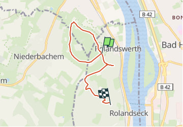
4,3 km | 5,5 km-effort
1h 15min
![](https://static1.geolcdn.com/siteimages/upload/files/16400158638029165_repeat_loop_refresh_sync_direction_icon.png)
Sí
![Excursión A pie Königswinter - [B] Beethoven Wanderweg - Photo](https://media.geolcdn.com/t/375/260/ext.jpg?maxdim=2&url=https%3A%2F%2Fmedia.geolcdn.com%2Ff%2Fa0531be5-8927-4495-bf61-2ab0d601589a.jpeg)
![A pie A pie](https://static1.geolcdn.com/sitytour/trail-icons/100.png)
[B] Beethoven Wanderweg
A pie
Medio
Königswinter,
Renania del Norte-Westfalia,
Rhein-Sieg-Kreis,
Germany
![](/images/other/stat-length.png)
15,3 km | 24 km-effort
5h 25min
![](https://static1.geolcdn.com/siteimages/upload/files/16400158638029165_repeat_loop_refresh_sync_direction_icon.png)
Sí
![Excursión A pie Bruchhausen - Rotbäckchen Rundwanderweg - Photo](https://media.geolcdn.com/t/375/260/ext.jpg?maxdim=2&url=https%3A%2F%2Fmedia.geolcdn.com%2Ff%2F1dd5c4a7-c3a6-459c-9cef-b7e5315b6005.jpeg)
![A pie A pie](https://static1.geolcdn.com/sitytour/trail-icons/100.png)
Rotbäckchen Rundwanderweg
A pie
Fácil
Bruchhausen,
Renania-Palatinado,
Landkreis Neuwied,
Germany
![](/images/other/stat-length.png)
11,1 km | 14,1 km-effort
3h 11min
![](https://static1.geolcdn.com/siteimages/upload/files/16400158638029165_repeat_loop_refresh_sync_direction_icon.png)
Sí
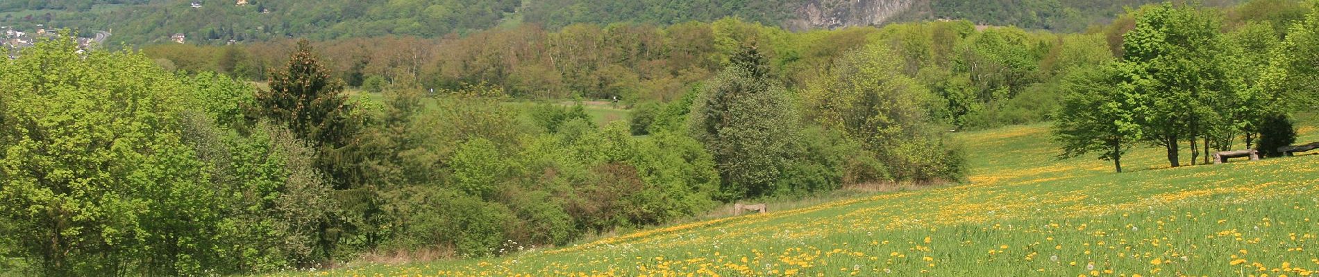
![Excursión A pie Remagen - [4] Oberwinter Rundwanderweg - Photo](https://media.geolcdn.com/t/375/260/ext.jpg?maxdim=2&url=https%3A%2F%2Fmedia.geolcdn.com%2Ff%2Fe27ef9e9-090e-4d77-ab64-ebc2130b65b2.jpeg)
![A pie A pie](https://static1.geolcdn.com/sitytour/trail-icons/100.png)
[4] Oberwinter Rundwanderweg
A pie
Fácil
Remagen,
Renania-Palatinado,
Landkreis Ahrweiler,
Germany
![](/images/other/stat-length.png)
4,9 km | 6,7 km-effort
1h 31min
![](https://static1.geolcdn.com/siteimages/upload/files/16400158638029165_repeat_loop_refresh_sync_direction_icon.png)
Sí
![Excursión A pie Remagen - [5] Oberwinter Rundwanderweg - Photo](https://media.geolcdn.com/t/375/260/ext.jpg?maxdim=2&url=https%3A%2F%2Fmedia.geolcdn.com%2Ff%2Ff5d36974-2dd7-4709-98b7-1c99706d0ead.jpeg)
![A pie A pie](https://static1.geolcdn.com/sitytour/trail-icons/100.png)
[5] Oberwinter Rundwanderweg
A pie
Fácil
Remagen,
Renania-Palatinado,
Landkreis Ahrweiler,
Germany
![](/images/other/stat-length.png)
9,1 km | 13,1 km-effort
2h 58min
![](https://static1.geolcdn.com/siteimages/upload/files/16400158638029165_repeat_loop_refresh_sync_direction_icon.png)
Sí
![Excursión A pie Remagen - [1] Oberwinter Wanderweg (Oberwinter - Rolandseck) - Photo](https://media.geolcdn.com/t/375/260/ext.jpg?maxdim=2&url=https%3A%2F%2Fmedia.geolcdn.com%2Ff%2F25784967-1970-4af5-8d60-8f5ed7fdcfe9.jpeg)
![A pie A pie](https://static1.geolcdn.com/sitytour/trail-icons/100.png)
[1] Oberwinter Wanderweg (Oberwinter - Rolandseck)
A pie
Fácil
Remagen,
Renania-Palatinado,
Landkreis Ahrweiler,
Germany
![](/images/other/stat-length.png)
3,7 km | 5,2 km-effort
1h 10min
![](https://static1.geolcdn.com/siteimages/upload/files/16400158638029165_repeat_loop_refresh_sync_direction_icon.png)
No
![Excursión A pie Wachtberg - Verbindungsweg - Photo](https://media.geolcdn.com/t/375/260/ext.jpg?maxdim=2&url=https%3A%2F%2Fmedia.geolcdn.com%2Ff%2F8a894d8e-564e-4043-b18c-669126bb6c29.jpeg)
![A pie A pie](https://static1.geolcdn.com/sitytour/trail-icons/100.png)
Verbindungsweg
A pie
Fácil
Wachtberg,
Renania del Norte-Westfalia,
Rhein-Sieg-Kreis,
Germany
![](/images/other/stat-length.png)
4,8 km | 6,1 km-effort
1h 22min
![](https://static1.geolcdn.com/siteimages/upload/files/16400158638029165_repeat_loop_refresh_sync_direction_icon.png)
No
![Excursión A pie Wachtberg - Dächelsberg-Runde - Photo](https://media.geolcdn.com/t/375/260/ext.jpg?maxdim=2&url=https%3A%2F%2Fmedia.geolcdn.com%2Ff%2Fc7273de2-5b65-4b43-93d9-f0b5ff3f0a2d.jpeg)
![A pie A pie](https://static1.geolcdn.com/sitytour/trail-icons/100.png)
Dächelsberg-Runde
A pie
Fácil
Wachtberg,
Renania del Norte-Westfalia,
Rhein-Sieg-Kreis,
Germany
![](/images/other/stat-length.png)
7,2 km | 8,9 km-effort
2h 1min
![](https://static1.geolcdn.com/siteimages/upload/files/16400158638029165_repeat_loop_refresh_sync_direction_icon.png)
Sí
![Excursión A pie Wachtberg - Hümerich-Runde - Photo](https://media.geolcdn.com/t/375/260/ext.jpg?maxdim=2&url=https%3A%2F%2Fmedia.geolcdn.com%2Ff%2Fb8080069-04dc-4f64-9b7d-918abc393f6f.jpeg)
![A pie A pie](https://static1.geolcdn.com/sitytour/trail-icons/100.png)
Hümerich-Runde
A pie
Fácil
Wachtberg,
Renania del Norte-Westfalia,
Rhein-Sieg-Kreis,
Germany
![](/images/other/stat-length.png)
5,9 km | 7,4 km-effort
1h 40min
![](https://static1.geolcdn.com/siteimages/upload/files/16400158638029165_repeat_loop_refresh_sync_direction_icon.png)
Sí