![](/images/other/stat-length.png)
![Excursión A pie Bad Salzdetfurth - R1 Rundwanderweg um den Sothenberg - Photo](https://media.geolcdn.com/t/1900/400/ext.pjpeg?maxdim=2&url=https%3A%2F%2Fmedia.geolcdn.com%2Ff%2F05f0189d-c0b9-4fc4-ad87-c395a8c87244.jpeg)
R1 Rundwanderweg um den Sothenberg
SityTrail - itinéraires balisés pédestres
Tous les sentiers balisés d’Europe PRO
![Longitud](/images/other/stat-length.png)
Longitud
4,2 km
![Altitud máxima](https://static1.geolcdn.com/siteimages/upload/files/1508320355ic_sort_altitude_max_24dp.png)
Altitud máxima
228 m
![Desnivel positivo](https://static1.geolcdn.com/siteimages/upload/files/1508320355ic_sort_den_pos_24dp.png)
Desnivel positivo
140 m
![Km-Effort](/images/other/stat-length.png)
Km-Effort
6,1 km
![Altitud mínima](https://static1.geolcdn.com/siteimages/upload/files/1508320355ic_sort_altitude_min_24dp.png)
Altitud mínima
100 m
![Desnivel negativo](https://static1.geolcdn.com/siteimages/upload/files/1508320355ic_sort_den_neg_24dp.png)
Desnivel negativo
140 m
![Boucle](https://static1.geolcdn.com/siteimages/upload/files/16400158638029165_repeat_loop_refresh_sync_direction_icon.png)
Boucle
Sí
Baliza
Fecha de creación :
2022-02-11 18:34:35.091
Última modificación :
2022-02-11 18:34:35.091
![A pie](https://static1.geolcdn.com/sitytour/trail-icons/100.png)
1h22
Dificultad : Fácil
![Escanee este código QR para abrir la excursión en la aplicación SityTrail](https://capi.geolives.com/qq0zvz2zws4bq2lad0pu/sitytour/trails/3099648/qr.png?size=200)
Aplicación GPS de excursión GRATIS
A propósito
Ruta A pie de 4,2 km a descubrir en Baja Sajonia, Landkreis Hildesheim, Bad Salzdetfurth. Esta ruta ha sido propuesta por SityTrail - itinéraires balisés pédestres.
Descripción
Symbol: weiße Buchstaben R1 auf blauem Grund
Sitio web: https://www.bad-salzdetfurth-guide.de/pdf/rundwanderweg_r1.pdf
Localización
País:
Germany
Región :
Baja Sajonia
Departamento/provincia :
Landkreis Hildesheim
Municipio :
Bad Salzdetfurth
Localidad:
Unknown
Salida:(Dec)
Salida:(UTM)
568956 ; 5768465 (32U) N.
Comentarios
Excursiones cerca
![Excursión A pie Bad Salzdetfurth - Sölter-Weg - Photo](https://media.geolcdn.com/t/375/260/ext.jpg?maxdim=2&url=https%3A%2F%2Fmedia.geolcdn.com%2Ff%2F578f3805-2242-484c-a9e4-a5ea73bea3fd.jpeg)
![A pie A pie](https://static1.geolcdn.com/sitytour/trail-icons/100.png)
Sölter-Weg
A pie
Difícil
Bad Salzdetfurth,
Baja Sajonia,
Landkreis Hildesheim,
Germany
![](/images/other/stat-length.png)
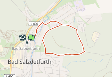
27 km | 37 km-effort
8h 20min
![](https://static1.geolcdn.com/siteimages/upload/files/16400158638029165_repeat_loop_refresh_sync_direction_icon.png)
No
![Excursión A pie Bad Salzdetfurth - R2 Rundwanderweg Ziegenberg - Photo](https://media.geolcdn.com/t/375/260/ext.jpg?maxdim=2&url=https%3A%2F%2Fmedia.geolcdn.com%2Ff%2F05f0189d-c0b9-4fc4-ad87-c395a8c87244.jpeg)
![A pie A pie](https://static1.geolcdn.com/sitytour/trail-icons/100.png)
R2 Rundwanderweg Ziegenberg
A pie
Fácil
Bad Salzdetfurth,
Baja Sajonia,
Landkreis Hildesheim,
Germany
![](/images/other/stat-length.png)
8,8 km | 12,2 km-effort
2h 46min
![](https://static1.geolcdn.com/siteimages/upload/files/16400158638029165_repeat_loop_refresh_sync_direction_icon.png)
Sí
![Excursión A pie Bad Salzdetfurth - Die Planetenstraße Bad Salzdetfurth - Photo](https://media.geolcdn.com/t/375/260/ext.jpg?maxdim=2&url=https%3A%2F%2Fmedia.geolcdn.com%2Ff%2Ff23f4797-32a7-4541-8a56-bae75521ea06.jpeg)
![A pie A pie](https://static1.geolcdn.com/sitytour/trail-icons/100.png)
Die Planetenstraße Bad Salzdetfurth
A pie
Fácil
Bad Salzdetfurth,
Baja Sajonia,
Landkreis Hildesheim,
Germany
![](/images/other/stat-length.png)
4,1 km | 4,5 km-effort
1h 1min
![](https://static1.geolcdn.com/siteimages/upload/files/16400158638029165_repeat_loop_refresh_sync_direction_icon.png)
No