![](/images/other/stat-length.png)
![Excursión A pie Villeneuve-en-Retz - Bourgneuf, les étangs , la campagne - Photo](https://media.geolcdn.com/t/1900/400/ext.pjpeg?maxdim=2&url=https%3A%2F%2Fstatic1.geolcdn.com%2Fsiteimages%2Fupload%2Ffiles%2F1545311037marcheuse_200dpi.jpg)
Bourgneuf, les étangs , la campagne
JCYOL44
Usuario
![Longitud](/images/other/stat-length.png)
![Altitud máxima](https://static1.geolcdn.com/siteimages/upload/files/1508320355ic_sort_altitude_max_24dp.png)
![Desnivel positivo](https://static1.geolcdn.com/siteimages/upload/files/1508320355ic_sort_den_pos_24dp.png)
![Km-Effort](/images/other/stat-length.png)
![Altitud mínima](https://static1.geolcdn.com/siteimages/upload/files/1508320355ic_sort_altitude_min_24dp.png)
![Desnivel negativo](https://static1.geolcdn.com/siteimages/upload/files/1508320355ic_sort_den_neg_24dp.png)
![Boucle](https://static1.geolcdn.com/siteimages/upload/files/16400158638029165_repeat_loop_refresh_sync_direction_icon.png)
![A pie](https://static1.geolcdn.com/sitytour/trail-icons/100.png)
2h28
Dificultad : Fácil
![Senderismo](https://static1.geolcdn.com/sitytour/trail-icons/101.png)
2h28
Dificultad : Medio
![Escanee este código QR para abrir la excursión en la aplicación SityTrail](https://capi.geolives.com/qq0zvz2zws4bq2lad0pu/sitytour/trails/3099233/qr.png?size=200)
Aplicación GPS de excursión GRATIS
A propósito
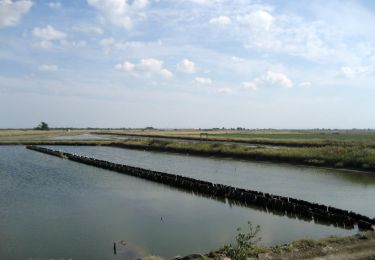
Ruta A pie de 10,2 km a descubrir en Países del Loira, Loira-Atlántico, Villeneuve-en-Retz. Esta ruta ha sido propuesta por JCYOL44.
Descripción
Départ / Arrivée au parking proche de l'étang et du cimetière. Longer les étangs puis par un petit tunnel passer la voie de chemin de fer pour continuer vers NOMBREUIL. Attention en traversant la D5 pour prendre le chemin qui mène à LA DAVIERE. Marcher jusqu'à une intersection .Prendre à gauche un chemin herbeux, voir gras humide en fonction de la météo. Continuer tout droit jusqu'à la D13 très passagère. Traverser le passage à niveau puis tourner à gauche sur une rue principale qui vous amène à un grand rond point. Revenir par la rue de la Taillée, le Musée du Pays de Retz, traverser le lotissement, face au mur du cimetière prendre à gauche. Traverser avec attention la D758, vous arrivez au parking
Localización
Comentarios
Excursiones cerca
![Excursión A pie Villeneuve-en-Retz - PDIPR:1224 - Photo](https://media.geolcdn.com/t/375/260/ext.jpg?maxdim=2&url=https%3A%2F%2Fmedia.geolcdn.com%2Ff%2F1a57d417-9132-4bf4-870f-21ad0636d79e.jpeg)
![A pie A pie](https://static1.geolcdn.com/sitytour/trail-icons/100.png)
A pie
![](/images/other/stat-length.png)
![](https://static1.geolcdn.com/siteimages/upload/files/16400158638029165_repeat_loop_refresh_sync_direction_icon.png)
![Excursión A pie Les Moutiers-en-Retz - Le Collet - Photo](https://media.geolcdn.com/t/375/260/ext.jpg?maxdim=2&url=https%3A%2F%2Fmedia.geolcdn.com%2Ff%2F1a57d417-9132-4bf4-870f-21ad0636d79e.jpeg)
![A pie A pie](https://static1.geolcdn.com/sitytour/trail-icons/100.png)
A pie
![](/images/other/stat-length.png)
![](https://static1.geolcdn.com/siteimages/upload/files/16400158638029165_repeat_loop_refresh_sync_direction_icon.png)
![Excursión Senderismo Villeneuve-en-Retz - Bourgneuf - Photo](https://media.geolcdn.com/t/375/260/ext.jpg?maxdim=2&url=https%3A%2F%2Fservices.sitytrail.com%2FGeolivesWS%2FDownloadMedia.ashx%3FTrailID%3D242333%26Media%3D004523e4-4d0d-4608-bfa3-e711e62ed1cc.jpg)
![Senderismo Senderismo](https://static1.geolcdn.com/sitytour/trail-icons/101.png)
Senderismo
![](/images/other/stat-length.png)
![](https://static1.geolcdn.com/siteimages/upload/files/16400158638029165_repeat_loop_refresh_sync_direction_icon.png)
![Excursión Bici de carretera Les Moutiers-en-Retz - 2023-06-25 port du collet -port des champs - port du bec A.R - Photo](https://media.geolcdn.com/t/375/260/ext.jpg?maxdim=2&url=https%3A%2F%2Fmedia.geolcdn.com%2Ff%2F239f987b-fb5d-4c97-a07a-46e1d6ee0353.jpg)
![Bici de carretera Bici de carretera](https://static1.geolcdn.com/sitytour/trail-icons/201.png)
Bici de carretera
![](/images/other/stat-length.png)
![](https://static1.geolcdn.com/siteimages/upload/files/16400158638029165_repeat_loop_refresh_sync_direction_icon.png)
![Excursión Senderismo Villeneuve-en-Retz - 2023-05-14 circuit des migrateurs - Bourgneuf en Retz - Villeneuve en Retz - Photo](https://media.geolcdn.com/t/375/260/ext.jpg?maxdim=2&url=https%3A%2F%2Fmedia.geolcdn.com%2Ff%2F1be5e16d-e40a-4440-a96a-f4180087ba32.jpg)
![Senderismo Senderismo](https://static1.geolcdn.com/sitytour/trail-icons/101.png)
Senderismo
![](/images/other/stat-length.png)
![](https://static1.geolcdn.com/siteimages/upload/files/16400158638029165_repeat_loop_refresh_sync_direction_icon.png)
![Excursión Senderismo Villeneuve-en-Retz - Bourgneuf - Pornic - Photo](https://media.geolcdn.com/t/375/260/ext.jpg?maxdim=2&url=https%3A%2F%2Fmedia.geolcdn.com%2Ff%2F990b9ccf-eba1-4846-b79b-2e31a5fdc003.jpg)
![Senderismo Senderismo](https://static1.geolcdn.com/sitytour/trail-icons/101.png)
Senderismo
![](/images/other/stat-length.png)
![](https://static1.geolcdn.com/siteimages/upload/files/16400158638029165_repeat_loop_refresh_sync_direction_icon.png)
![Excursión A pie Villeneuve-en-Retz - Les Ajoncs - Photo](https://media.geolcdn.com/t/375/260/ext.jpg?maxdim=2&url=https%3A%2F%2Fmedia.geolcdn.com%2Ff%2Fa75d8add-319e-469f-abc7-7f7c6664ec76.jpeg)
![A pie A pie](https://static1.geolcdn.com/sitytour/trail-icons/100.png)
A pie
![](/images/other/stat-length.png)
![](https://static1.geolcdn.com/siteimages/upload/files/16400158638029165_repeat_loop_refresh_sync_direction_icon.png)
![Excursión Senderismo Les Moutiers-en-Retz - De Prigny à la Guérivière - Photo](https://media.geolcdn.com/t/375/260/ext.jpg?maxdim=2&url=https%3A%2F%2Fmedia.geolcdn.com%2Ff%2F732414e1-0d73-4bb4-8cbc-0e2adbd9a7b9.jpg)
![Senderismo Senderismo](https://static1.geolcdn.com/sitytour/trail-icons/101.png)
Senderismo
![](/images/other/stat-length.png)
![](https://static1.geolcdn.com/siteimages/upload/files/16400158638029165_repeat_loop_refresh_sync_direction_icon.png)
![Excursión Bicicleta Les Moutiers-en-Retz - Prigny vélo - Photo](https://media.geolcdn.com/t/375/260/ext.jpg?maxdim=2&url=https%3A%2F%2Fmedia.geolcdn.com%2Ff%2F5d7bd996-9430-4362-855e-5cd32cea415b.jpg)
![Bicicleta Bicicleta](https://static1.geolcdn.com/sitytour/trail-icons/200.png)
Bicicleta
![](/images/other/stat-length.png)
![](https://static1.geolcdn.com/siteimages/upload/files/16400158638029165_repeat_loop_refresh_sync_direction_icon.png)