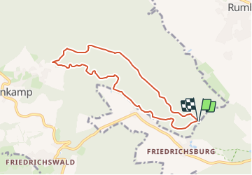
![](/images/other/stat-length.png)
![Excursión A pie Rinteln - RI15 Schullandheim Route - Photo](https://media.geolcdn.com/t/1900/400/920c7d2e-1cd1-473a-8245-034e1bafe258.jpeg&format=pjpeg&maxdim=2)
RI15 Schullandheim Route
SityTrail - itinéraires balisés pédestres
Tous les sentiers balisés d’Europe GUIDE+
![Longitud](/images/other/stat-length.png)
![Altitud máxima](https://static1.geolcdn.com/siteimages/upload/files/1508320355ic_sort_altitude_max_24dp.png)
![Desnivel positivo](https://static1.geolcdn.com/siteimages/upload/files/1508320355ic_sort_den_pos_24dp.png)
![Km-Effort](/images/other/stat-length.png)
![Altitud mínima](https://static1.geolcdn.com/siteimages/upload/files/1508320355ic_sort_altitude_min_24dp.png)
![Desnivel negativo](https://static1.geolcdn.com/siteimages/upload/files/1508320355ic_sort_den_neg_24dp.png)
![Boucle](https://static1.geolcdn.com/siteimages/upload/files/16400158638029165_repeat_loop_refresh_sync_direction_icon.png)
![A pie](https://static1.geolcdn.com/sitytour/trail-icons/100.png)
2h04
Dificultad : Fácil
![Escanee este código QR para abrir la excursión en la aplicación SityTrail](https://capi.geolives.com/qq0zvz2zws4bq2lad0pu/sitytour/trails/3099213/qr.png?size=200)
Aplicación GPS de excursión GRATIS
A propósito
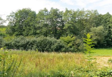
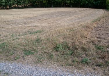
Ruta A pie de 6,8 km a descubrir en Baja Sajonia, Landkreis Schaumburg, Rinteln. Esta ruta ha sido propuesta por SityTrail - itinéraires balisés pédestres.
Descripción
Symbol: Blaue 15 auf gelbem Grund
Sitio web: https://pages.et4.de/de/westliches-weserbergland_neu/default/detail/Tour/A1F7C17AF0465B552A271169E7AA2673/ri15-schullandheim-route
Localización
Comentarios
Excursiones cerca
![Excursión A pie Rinteln - RI18 Friedrichsburg-Route - Photo](https://media.geolcdn.com/t/375/260/920c7d2e-1cd1-473a-8245-034e1bafe258.jpeg&format=jpg&maxdim=2)
![A pie A pie](https://static1.geolcdn.com/sitytour/trail-icons/100.png)
A pie
![](/images/other/stat-length.png)
![](https://static1.geolcdn.com/siteimages/upload/files/16400158638029165_repeat_loop_refresh_sync_direction_icon.png)
![Excursión A pie Rinteln - RI19 Rundwanderweg Goldbeck - Photo](https://media.geolcdn.com/t/375/260/e1fdec07-7e8b-426c-9552-25534ae24956.jpeg&format=jpg&maxdim=2)
![A pie A pie](https://static1.geolcdn.com/sitytour/trail-icons/100.png)
A pie
![](/images/other/stat-length.png)
![](https://static1.geolcdn.com/siteimages/upload/files/16400158638029165_repeat_loop_refresh_sync_direction_icon.png)
![Excursión A pie Rinteln - RI12 Schlingborn-Route - Photo](https://media.geolcdn.com/t/375/260/dec5a7fd-92ec-4454-b0d0-59b71b39ea43.jpeg&format=jpg&maxdim=2)
![A pie A pie](https://static1.geolcdn.com/sitytour/trail-icons/100.png)
A pie
![](/images/other/stat-length.png)
![](https://static1.geolcdn.com/siteimages/upload/files/16400158638029165_repeat_loop_refresh_sync_direction_icon.png)
![Excursión A pie Hessisch Oldendorf - HO13 - Friedrichshagen-Route - Photo](https://media.geolcdn.com/t/375/260/fadbacb7-844f-4cdb-9125-789c662789ff.jpeg&format=jpg&maxdim=2)
![A pie A pie](https://static1.geolcdn.com/sitytour/trail-icons/100.png)
A pie
![](/images/other/stat-length.png)
![](https://static1.geolcdn.com/siteimages/upload/files/16400158638029165_repeat_loop_refresh_sync_direction_icon.png)
![Excursión A pie Extertal - Uffopfad, Extertal - Photo](https://media.geolcdn.com/t/375/260/59f02047-bade-4a2b-b51d-46857522fbcf.jpeg&format=jpg&maxdim=2)
![A pie A pie](https://static1.geolcdn.com/sitytour/trail-icons/100.png)
A pie
![](/images/other/stat-length.png)
![](https://static1.geolcdn.com/siteimages/upload/files/16400158638029165_repeat_loop_refresh_sync_direction_icon.png)
![Excursión A pie Extertal - A4, Extertal/ Wanderparkplatz Hagendorf-Hellerberg-Uffoburg-Hagenberg - Photo](https://media.geolcdn.com/t/375/260/59f02047-bade-4a2b-b51d-46857522fbcf.jpeg&format=jpg&maxdim=2)
![A pie A pie](https://static1.geolcdn.com/sitytour/trail-icons/100.png)
A pie
![](/images/other/stat-length.png)
![](https://static1.geolcdn.com/siteimages/upload/files/16400158638029165_repeat_loop_refresh_sync_direction_icon.png)
![Excursión A pie Extertal - A1, Extertal/ Rott - Photo](https://media.geolcdn.com/t/375/260/59f02047-bade-4a2b-b51d-46857522fbcf.jpeg&format=jpg&maxdim=2)
![A pie A pie](https://static1.geolcdn.com/sitytour/trail-icons/100.png)
A pie
![](/images/other/stat-length.png)
![](https://static1.geolcdn.com/siteimages/upload/files/16400158638029165_repeat_loop_refresh_sync_direction_icon.png)
![Excursión A pie Rinteln - A2, Extertal/ Rott - Photo](https://media.geolcdn.com/t/375/260/e1d24005-d96c-443d-a07a-b6893db4feae.jpeg&format=jpg&maxdim=2)
![A pie A pie](https://static1.geolcdn.com/sitytour/trail-icons/100.png)
A pie
![](/images/other/stat-length.png)
![](https://static1.geolcdn.com/siteimages/upload/files/16400158638029165_repeat_loop_refresh_sync_direction_icon.png)
![Excursión A pie Rinteln - RI21Rundwanderweg Ludwigsturm - Photo](https://media.geolcdn.com/t/375/260/dec5a7fd-92ec-4454-b0d0-59b71b39ea43.jpeg&format=jpg&maxdim=2)
![A pie A pie](https://static1.geolcdn.com/sitytour/trail-icons/100.png)
A pie
![](/images/other/stat-length.png)
![](https://static1.geolcdn.com/siteimages/upload/files/16400158638029165_repeat_loop_refresh_sync_direction_icon.png)