![](/images/other/stat-length.png)
![Excursión A pie Bad Lippspringe - Leopoldstal - Photo](https://media.geolcdn.com/t/1900/400/602c2ead-73bf-434c-bd75-7d6891902759.jpeg&format=pjpeg&maxdim=2)
Leopoldstal
SityTrail - itinéraires balisés pédestres
Tous les sentiers balisés d’Europe GUIDE+
![Longitud](/images/other/stat-length.png)
Longitud
9,5 km
![Altitud máxima](https://static1.geolcdn.com/siteimages/upload/files/1508320355ic_sort_altitude_max_24dp.png)
Altitud máxima
434 m
![Desnivel positivo](https://static1.geolcdn.com/siteimages/upload/files/1508320355ic_sort_den_pos_24dp.png)
Desnivel positivo
59 m
![Km-Effort](/images/other/stat-length.png)
Km-Effort
11,2 km
![Altitud mínima](https://static1.geolcdn.com/siteimages/upload/files/1508320355ic_sort_altitude_min_24dp.png)
Altitud mínima
154 m
![Desnivel negativo](https://static1.geolcdn.com/siteimages/upload/files/1508320355ic_sort_den_neg_24dp.png)
Desnivel negativo
337 m
![Boucle](https://static1.geolcdn.com/siteimages/upload/files/16400158638029165_repeat_loop_refresh_sync_direction_icon.png)
Boucle
No
Baliza
Fecha de creación :
2022-02-11 18:02:31.737
Última modificación :
2022-02-11 18:02:31.737
![A pie](https://static1.geolcdn.com/sitytour/trail-icons/100.png)
2h32
Dificultad : Fácil
![Escanee este código QR para abrir la excursión en la aplicación SityTrail](https://capi.geolives.com/qq0zvz2zws4bq2lad0pu/sitytour/trails/3098959/qr.png?size=200)
Aplicación GPS de excursión GRATIS
A propósito
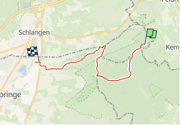
Ruta A pie de 9,5 km a descubrir en Renania del Norte-Westfalia, Kreis Paderborn, Bad Lippspringe. Esta ruta ha sido propuesta por SityTrail - itinéraires balisés pédestres.
Descripción
Trail created by Eggegebirgsverein.
Symbol: white vertical bar on black background
Localización
País:
Germany
Región :
Renania del Norte-Westfalia
Departamento/provincia :
Kreis Paderborn
Municipio :
Bad Lippspringe
Localidad:
Unknown
Salida:(Dec)
Salida:(UTM)
494535 ; 5739290 (32U) N.
Comentarios
Excursiones cerca
![Excursión A pie Horn-Bad Meinberg - Pilgerweg](https://media.geolcdn.com/t/375/260/82208e22-56ad-4715-9507-28234728434e.jpeg&format=jpg&maxdim=2)
![A pie A pie](https://static1.geolcdn.com/sitytour/trail-icons/100.png)
Pilgerweg "Besinn DICH… SEHEN, HÖREN, FÜHLEN - Besinnungsweg Kempen-Feldrom-V...
A pie
Fácil
Horn-Bad Meinberg,
Renania del Norte-Westfalia,
Kreis Lippe,
Germany
![](/images/other/stat-length.png)
3,1 km | 4,3 km-effort
58min
![](https://static1.geolcdn.com/siteimages/upload/files/16400158638029165_repeat_loop_refresh_sync_direction_icon.png)
Sí
![Excursión A pie Horn-Bad Meinberg - Besinnungsweg (Kempen-Feldrom-Veldrom) - Photo](https://media.geolcdn.com/t/375/260/82208e22-56ad-4715-9507-28234728434e.jpeg&format=jpg&maxdim=2)
![A pie A pie](https://static1.geolcdn.com/sitytour/trail-icons/100.png)
Besinnungsweg (Kempen-Feldrom-Veldrom)
A pie
Fácil
Horn-Bad Meinberg,
Renania del Norte-Westfalia,
Kreis Lippe,
Germany
![](/images/other/stat-length.png)
4,5 km | 5,9 km-effort
1h 20min
![](https://static1.geolcdn.com/siteimages/upload/files/16400158638029165_repeat_loop_refresh_sync_direction_icon.png)
No
![Excursión A pie Bad Lippspringe - Buchen-Wildnis-Pfad (Naturerbe Wanderwelt Altenbeken) - Photo](https://media.geolcdn.com/t/375/260/092b50ca-0a38-4367-9c3b-580ce26d07c4.jpeg&format=jpg&maxdim=2)
![A pie A pie](https://static1.geolcdn.com/sitytour/trail-icons/100.png)
Buchen-Wildnis-Pfad (Naturerbe Wanderwelt Altenbeken)
A pie
Fácil
Bad Lippspringe,
Renania del Norte-Westfalia,
Kreis Paderborn,
Germany
![](/images/other/stat-length.png)
4,7 km | 6,3 km-effort
1h 25min
![](https://static1.geolcdn.com/siteimages/upload/files/16400158638029165_repeat_loop_refresh_sync_direction_icon.png)
Sí
![Excursión A pie Bad Lippspringe - = (Bad Lippspringe) - Photo](https://media.geolcdn.com/t/375/260/3373c4ee-ec63-4287-93d3-4012117969b2.jpeg&format=jpg&maxdim=2)
![A pie A pie](https://static1.geolcdn.com/sitytour/trail-icons/100.png)
= (Bad Lippspringe)
A pie
Fácil
Bad Lippspringe,
Renania del Norte-Westfalia,
Kreis Paderborn,
Germany
![](/images/other/stat-length.png)
5 km | 7,5 km-effort
1h 42min
![](https://static1.geolcdn.com/siteimages/upload/files/16400158638029165_repeat_loop_refresh_sync_direction_icon.png)
No
![Excursión A pie Bad Lippspringe - Delta (Bad Lippspringe) - Photo](https://media.geolcdn.com/t/375/260/092b50ca-0a38-4367-9c3b-580ce26d07c4.jpeg&format=jpg&maxdim=2)
![A pie A pie](https://static1.geolcdn.com/sitytour/trail-icons/100.png)
Delta (Bad Lippspringe)
A pie
Fácil
Bad Lippspringe,
Renania del Norte-Westfalia,
Kreis Paderborn,
Germany
![](/images/other/stat-length.png)
4,9 km | 6,5 km-effort
1h 28min
![](https://static1.geolcdn.com/siteimages/upload/files/16400158638029165_repeat_loop_refresh_sync_direction_icon.png)
No
![Excursión A pie Horn-Bad Meinberg - Rundwanderweg A4 [Feldrom] - Photo](https://media.geolcdn.com/t/375/260/c3e2fda2-4a4b-4515-b251-ad31aeb36002.jpeg&format=jpg&maxdim=2)
![A pie A pie](https://static1.geolcdn.com/sitytour/trail-icons/100.png)
Rundwanderweg A4 [Feldrom]
A pie
Fácil
Horn-Bad Meinberg,
Renania del Norte-Westfalia,
Kreis Lippe,
Germany
![](/images/other/stat-length.png)
3,3 km | 4,7 km-effort
1h 4min
![](https://static1.geolcdn.com/siteimages/upload/files/16400158638029165_repeat_loop_refresh_sync_direction_icon.png)
Sí
![Excursión A pie Horn-Bad Meinberg - Rundwanderweg A2 [Feldrom] - Photo](https://media.geolcdn.com/t/375/260/82208e22-56ad-4715-9507-28234728434e.jpeg&format=jpg&maxdim=2)
![A pie A pie](https://static1.geolcdn.com/sitytour/trail-icons/100.png)
Rundwanderweg A2 [Feldrom]
A pie
Fácil
Horn-Bad Meinberg,
Renania del Norte-Westfalia,
Kreis Lippe,
Germany
![](/images/other/stat-length.png)
3,4 km | 5,1 km-effort
1h 8min
![](https://static1.geolcdn.com/siteimages/upload/files/16400158638029165_repeat_loop_refresh_sync_direction_icon.png)
Sí
![Excursión A pie Steinheim - Rundwanderweg A1 [Grevenhagen] - Photo](https://media.geolcdn.com/t/375/260/202ac17e-dbff-44d1-b3d9-93eb341f466c.jpeg&format=jpg&maxdim=2)
![A pie A pie](https://static1.geolcdn.com/sitytour/trail-icons/100.png)
Rundwanderweg A1 [Grevenhagen]
A pie
Fácil
Steinheim,
Renania del Norte-Westfalia,
Kreis Höxter,
Germany
![](/images/other/stat-length.png)
8,3 km | 11 km-effort
2h 30min
![](https://static1.geolcdn.com/siteimages/upload/files/16400158638029165_repeat_loop_refresh_sync_direction_icon.png)
Sí
![Excursión A pie Altenbeken - Durbeke-Steig (Naturerbe Wanderwelt Altenbeken) - Photo](https://media.geolcdn.com/t/375/260/01d02757-c856-4cdc-aee4-abafe2ca25b9.jpeg&format=jpg&maxdim=2)
![A pie A pie](https://static1.geolcdn.com/sitytour/trail-icons/100.png)
Durbeke-Steig (Naturerbe Wanderwelt Altenbeken)
A pie
Fácil
Altenbeken,
Renania del Norte-Westfalia,
Kreis Paderborn,
Germany
![](/images/other/stat-length.png)
7,5 km | 9,8 km-effort
2h 13min
![](https://static1.geolcdn.com/siteimages/upload/files/16400158638029165_repeat_loop_refresh_sync_direction_icon.png)
No