![](/images/other/stat-length.png)
![Excursión A pie Neu-Bamberg - Küstenweg 1: Rundweg Siefersheim - Wöllstein - Neubamberg - Photo](https://media.geolcdn.com/t/1900/400/ext.pjpeg?maxdim=2&url=https%3A%2F%2Fmedia.geolcdn.com%2Ff%2F65411264-3fd6-45c8-83af-03425fe7346d.jpeg)
Küstenweg 1: Rundweg Siefersheim - Wöllstein - Neubamberg
SityTrail - itinéraires balisés pédestres
Tous les sentiers balisés d’Europe PRO
![Longitud](/images/other/stat-length.png)
Longitud
11,8 km
![Altitud máxima](https://static1.geolcdn.com/siteimages/upload/files/1508320355ic_sort_altitude_max_24dp.png)
Altitud máxima
229 m
![Desnivel positivo](https://static1.geolcdn.com/siteimages/upload/files/1508320355ic_sort_den_pos_24dp.png)
Desnivel positivo
265 m
![Km-Effort](/images/other/stat-length.png)
Km-Effort
15,3 km
![Altitud mínima](https://static1.geolcdn.com/siteimages/upload/files/1508320355ic_sort_altitude_min_24dp.png)
Altitud mínima
137 m
![Desnivel negativo](https://static1.geolcdn.com/siteimages/upload/files/1508320355ic_sort_den_neg_24dp.png)
Desnivel negativo
270 m
![Boucle](https://static1.geolcdn.com/siteimages/upload/files/16400158638029165_repeat_loop_refresh_sync_direction_icon.png)
Boucle
Sí
Baliza
Fecha de creación :
2022-02-11 17:46:57.592
Última modificación :
2022-02-11 17:46:57.592
![A pie](https://static1.geolcdn.com/sitytour/trail-icons/100.png)
3h29
Dificultad : Fácil
![Escanee este código QR para abrir la excursión en la aplicación SityTrail](https://capi.geolives.com/qq0zvz2zws4bq2lad0pu/sitytour/trails/3098519/qr.png?size=200)
Aplicación GPS de excursión GRATIS
A propósito
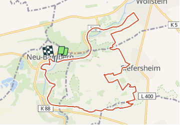
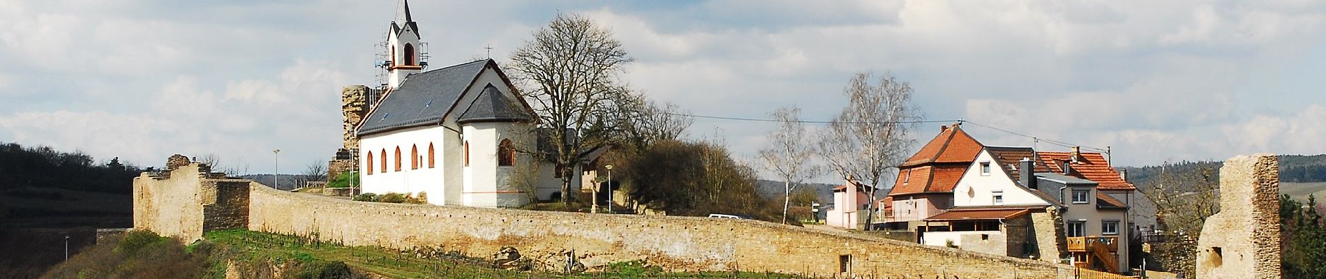
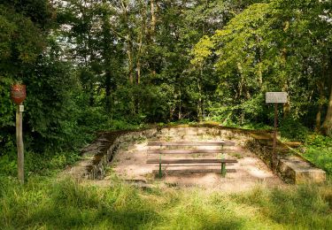
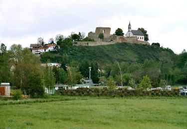
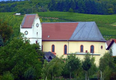
Ruta A pie de 11,8 km a descubrir en Renania-Palatinado, Landkreis Bad Kreuznach, Neu-Bamberg. Esta ruta ha sido propuesta por SityTrail - itinéraires balisés pédestres.
Descripción
Trail created by Zweckverband Erholungsgebiet "Rheinhessische Schweiz".
Symbol: gelbes K vor Strandsymbol
Localización
País:
Germany
Región :
Renania-Palatinado
Departamento/provincia :
Landkreis Bad Kreuznach
Municipio :
Neu-Bamberg
Localidad:
Unknown
Salida:(Dec)
Salida:(UTM)
422853 ; 5516798 (32U) N.
Comentarios
Excursiones cerca
![Excursión A pie Bad Kreuznach - Bäderhöhenweg 5km - Photo](https://media.geolcdn.com/t/375/260/ext.jpg?maxdim=2&url=https%3A%2F%2Fmedia.geolcdn.com%2Ff%2F9ee6532b-8b87-4b5a-bf29-6ac4fa517dd6.jpeg)
![A pie A pie](https://static1.geolcdn.com/sitytour/trail-icons/100.png)
Bäderhöhenweg 5km
A pie
Fácil
Bad Kreuznach,
Renania-Palatinado,
Landkreis Bad Kreuznach,
Germany
![](/images/other/stat-length.png)
5 km | 6,3 km-effort
1h 25min
![](https://static1.geolcdn.com/siteimages/upload/files/16400158638029165_repeat_loop_refresh_sync_direction_icon.png)
Sí
![Excursión A pie Altenbamberg - VITALtour Rheingrafenstein - Photo](https://media.geolcdn.com/t/375/260/ext.jpg?maxdim=2&url=https%3A%2F%2Fmedia.geolcdn.com%2Ff%2F690c3691-3353-4205-bd12-5609d191005f.jpeg)
![A pie A pie](https://static1.geolcdn.com/sitytour/trail-icons/100.png)
VITALtour Rheingrafenstein
A pie
Fácil
Altenbamberg,
Renania-Palatinado,
Landkreis Bad Kreuznach,
Germany
![](/images/other/stat-length.png)
6,5 km | 8,2 km-effort
1h 51min
![](https://static1.geolcdn.com/siteimages/upload/files/16400158638029165_repeat_loop_refresh_sync_direction_icon.png)
No
![Excursión A pie Bad Kreuznach - CLASSICtour Rheingrafenstein - Photo](https://media.geolcdn.com/t/375/260/ext.jpg?maxdim=2&url=https%3A%2F%2Fmedia.geolcdn.com%2Ff%2F690c3691-3353-4205-bd12-5609d191005f.jpeg)
![A pie A pie](https://static1.geolcdn.com/sitytour/trail-icons/100.png)
CLASSICtour Rheingrafenstein
A pie
Fácil
Bad Kreuznach,
Renania-Palatinado,
Landkreis Bad Kreuznach,
Germany
![](/images/other/stat-length.png)
9,2 km | 12,7 km-effort
2h 53min
![](https://static1.geolcdn.com/siteimages/upload/files/16400158638029165_repeat_loop_refresh_sync_direction_icon.png)
Sí
![Excursión A pie Bad Kreuznach - INTROtour Rheingrafenstein - Photo](https://media.geolcdn.com/t/375/260/ext.jpg?maxdim=2&url=https%3A%2F%2Fmedia.geolcdn.com%2Ff%2F690c3691-3353-4205-bd12-5609d191005f.jpeg)
![A pie A pie](https://static1.geolcdn.com/sitytour/trail-icons/100.png)
INTROtour Rheingrafenstein
A pie
Fácil
Bad Kreuznach,
Renania-Palatinado,
Landkreis Bad Kreuznach,
Germany
![](/images/other/stat-length.png)
3,2 km | 4,3 km-effort
57min
![](https://static1.geolcdn.com/siteimages/upload/files/16400158638029165_repeat_loop_refresh_sync_direction_icon.png)
Sí
![Excursión A pie Frei-Laubersheim - Rundwanderweg Frei-Laubersheim 20 - Photo](https://media.geolcdn.com/t/375/260/ext.jpg?maxdim=2&url=https%3A%2F%2Fmedia.geolcdn.com%2Ff%2F3d4782e9-21ff-4a3b-92f1-a704acc563fb.jpeg)
![A pie A pie](https://static1.geolcdn.com/sitytour/trail-icons/100.png)
Rundwanderweg Frei-Laubersheim 20
A pie
Fácil
Frei-Laubersheim,
Renania-Palatinado,
Landkreis Bad Kreuznach,
Germany
![](/images/other/stat-length.png)
4,3 km | 5,7 km-effort
1h 17min
![](https://static1.geolcdn.com/siteimages/upload/files/16400158638029165_repeat_loop_refresh_sync_direction_icon.png)
Sí
![Excursión A pie Frei-Laubersheim - Hiwweltour Eichelberg - Photo](https://media.geolcdn.com/t/375/260/ext.jpg?maxdim=2&url=https%3A%2F%2Fmedia.geolcdn.com%2Ff%2F6453f7c0-1b57-468f-b2b0-ac897a4db66c.jpeg)
![A pie A pie](https://static1.geolcdn.com/sitytour/trail-icons/100.png)
Hiwweltour Eichelberg
A pie
Fácil
Frei-Laubersheim,
Renania-Palatinado,
Landkreis Bad Kreuznach,
Germany
![](/images/other/stat-length.png)
11,3 km | 15,4 km-effort
3h 30min
![](https://static1.geolcdn.com/siteimages/upload/files/16400158638029165_repeat_loop_refresh_sync_direction_icon.png)
Sí
![Excursión A pie Neu-Bamberg - Hiwweltour Heideblick - Photo](https://media.geolcdn.com/t/375/260/ext.jpg?maxdim=2&url=https%3A%2F%2Fmedia.geolcdn.com%2Ff%2F6453f7c0-1b57-468f-b2b0-ac897a4db66c.jpeg)
![A pie A pie](https://static1.geolcdn.com/sitytour/trail-icons/100.png)
Hiwweltour Heideblick
A pie
Fácil
Neu-Bamberg,
Renania-Palatinado,
Landkreis Bad Kreuznach,
Germany
![](/images/other/stat-length.png)
9,8 km | 13,1 km-effort
2h 58min
![](https://static1.geolcdn.com/siteimages/upload/files/16400158638029165_repeat_loop_refresh_sync_direction_icon.png)
Sí
![Excursión A pie Bad Kreuznach - Bäderhöhenweg 21km - Photo](https://media.geolcdn.com/t/375/260/ext.jpg?maxdim=2&url=https%3A%2F%2Fmedia.geolcdn.com%2Ff%2F9ee6532b-8b87-4b5a-bf29-6ac4fa517dd6.jpeg)
![A pie A pie](https://static1.geolcdn.com/sitytour/trail-icons/100.png)
Bäderhöhenweg 21km
A pie
Fácil
Bad Kreuznach,
Renania-Palatinado,
Landkreis Bad Kreuznach,
Germany
![](/images/other/stat-length.png)
7,5 km | 9,9 km-effort
2h 15min
![](https://static1.geolcdn.com/siteimages/upload/files/16400158638029165_repeat_loop_refresh_sync_direction_icon.png)
No
![Excursión A pie Frei-Laubersheim - Rundwanderweg Frei-Laubersheim 22 - Photo](https://media.geolcdn.com/t/375/260/ext.jpg?maxdim=2&url=https%3A%2F%2Fmedia.geolcdn.com%2Ff%2Fb482b1bc-1c82-42dc-97e9-ce78cb8b29c6.jpeg)
![A pie A pie](https://static1.geolcdn.com/sitytour/trail-icons/100.png)
Rundwanderweg Frei-Laubersheim 22
A pie
Fácil
Frei-Laubersheim,
Renania-Palatinado,
Landkreis Bad Kreuznach,
Germany
![](/images/other/stat-length.png)
6,5 km | 8,4 km-effort
1h 54min
![](https://static1.geolcdn.com/siteimages/upload/files/16400158638029165_repeat_loop_refresh_sync_direction_icon.png)
Sí